| Hurricane Basics |
| 1997 Names | 1998 Names | ||
|---|---|---|---|
| Ana | Larry | Alex | Lisa |
| Bill | Mindy | Bonnie | Mitch |
| Claudette | Nicholas | Charley | Nicole |
| Danny | Odette | Danielle | Otto |
| Erika | Peter | Earl | Paula |
| Fabian | Rose | Frances | Richard |
| Grace | Sam | Georges | Shary |
| Henri | Teresa | Hermine | Tomas |
| Isabel | Victor | Ivan | Virginie |
| Juan | Wanda | Jeanne | Walter |
| Kate | Karl | ||
The Saffir-Simpson Damage-Potential Scale
| Category | Central Pressure | Winds | Surge |
|---|---|---|---|
| 1 - Minimal | greater than 980 mb or 28.94 in | 74-95 mph or 64-83 kts | 4-5 ft. |
| 2 - Moderate | 965-979 mb or 28.50-28.91 in | 96-110 mph or 65-96 kts | 6-8 ft. |
| 3 - Extensive | 945-964 mb or 27.91-28.47 in | 111-130 mph or 97-113 kts | 9-12ft. |
| 4 - Extreme | 920-944 mb or 27.17-27.88 in | 131-155 mph or 114-135 kts | 13-18 ft. |
| 5 - Catastrophic | less than 920 mb or 27.17 in | greater than 155 mph or 135 kts | greater than 18 ft. |
Category 1 [Minimal]
Catetgory 2 [Moderate]
Category 3 [Extensive]
Category 4 [Extreme]
Category 5 [Catastrophic]
Ā
Structure of a Hurricane...
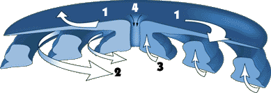 1. Outflow. The high level clouds moving clockwise out away from the hurricane at
heights of over 35,000 feet. These clouds are indicative of air spreading
out over the top of the storm, which is essential to its development.
1. Outflow. The high level clouds moving clockwise out away from the hurricane at
heights of over 35,000 feet. These clouds are indicative of air spreading
out over the top of the storm, which is essential to its development.
2. Feeder Bands. These are squally bands of showers characterized by strong
gusty winds and heavy rains. These bands become more pronounced as the storm
intensifies, and are fed by the warm ocean.
3. The Eyewall. A band of clouds, strong winds and heavy rains
surrounding the eye of the storm. At the eyewall, there is rapid movement of
air toward the center and upward into the cloud.
4. The Eye. What goes up must come down, so with the violent rising air
converging toward the storm center at the eye, sinking air develops within.
This air dries out, creating the clear, calm eye. Winds are very light here
since the focus of convergence and hence strong winds are in the eyewall.

Low pressure in the hurricane acts as a plunger, pulling up
the water level. Higher water level allows waves to strike
farther inland, causing massive property damage.
The strongest surge comes ashore just to the right of the eye,
where the fierce hurricane winds are blowing toward land. Winds on
the left side of the storm might actually cause the water level to
run slightly lower than normal.
1. Outflow. The high level clouds moving clockwise out away from the hurricane at
heights of over 35,000 feet. These clouds are indicative of air spreading
out over the top of the storm, which is essential to its development.2. Feeder Bands. These are squally bands of showers characterized by strong gusty winds and heavy rains. These bands become more pronounced as the storm intensifies, and are fed by the warm ocean.
3. The Eyewall. A band of clouds, strong winds and heavy rains surrounding the eye of the storm. At the eyewall, there is rapid movement of air toward the center and upward into the cloud.
4. The Eye. What goes up must come down, so with the violent rising air
converging toward the storm center at the eye, sinking air develops within.
This air dries out, creating the clear, calm eye. Winds are very light here
since the focus of convergence and hence strong winds are in the eyewall.
Low pressure in the hurricane acts as a plunger, pulling up
the water level. Higher water level allows waves to strike
farther inland, causing massive property damage.
The strongest surge comes ashore just to the right of the eye,
where the fierce hurricane winds are blowing toward land. Winds on
the left side of the storm might actually cause the water level to
run slightly lower than normal.