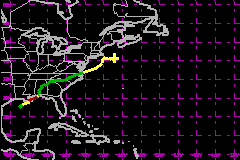
Hurricane Danny:
Maximum Winds-80mph....Minimum Pressure-984mbs....July 16th-26th


Track Coordinates
On July 16th tropical depression four formed in the North Central Gulf from the remnants of a thunderstorm
complex. It meandered a slowly moved NE and the winds reached 50mph, a tropical storm. It continued to gain
strength and move NE. Tropcial Storm and Hurricane warnings where issued. It then strengthened to a
hurricane(75mph) while or just before crossing Grand Isle, LA. Hurricane Danny then drifted NE over open Gulf
waters into Mobile Bay where it stregthened to a 80mph hurricane. It churned up waters there and then after
several hours it moved inland near Mobile Bay. Danny weakened to a depression, and then to a land low. It moved
through the Southeast while maintaining a great circulation. Then, something uncommon happened; Danny began
gaining strength while still over North Carolina soil. By the time it reached the Atlantic it was renamed Tropcial
Storm Danny off the coast of Norfolk, Virginia. Danny moved radily to the NE and its winds strengthened to
60mph. Tropical Storm warnings were issued for areas around Cape Cod, but luckily Danny passed east of Cape
Cod and weakened, becoming extratropical.
This page hosted by
 Get your own Free Home Page

|
 
|
Track Coordinates
On July 16th tropical depression four formed in the North Central Gulf from the remnants of a thunderstorm
complex. It meandered a slowly moved NE and the winds reached 50mph, a tropical storm. It continued to gain
strength and move NE. Tropcial Storm and Hurricane warnings where issued. It then strengthened to a
hurricane(75mph) while or just before crossing Grand Isle, LA. Hurricane Danny then drifted NE over open Gulf
waters into Mobile Bay where it stregthened to a 80mph hurricane. It churned up waters there and then after
several hours it moved inland near Mobile Bay. Danny weakened to a depression, and then to a land low. It moved
through the Southeast while maintaining a great circulation. Then, something uncommon happened; Danny began
gaining strength while still over North Carolina soil. By the time it reached the Atlantic it was renamed Tropcial
Storm Danny off the coast of Norfolk, Virginia. Danny moved radily to the NE and its winds strengthened to
60mph. Tropical Storm warnings were issued for areas around Cape Cod, but luckily Danny passed east of Cape
Cod and weakened, becoming extratropical.
This page hosted by
 Get your own Free Home Page
 Get your own Free Home Page