
|
Cley Hill |
More pictures here |
|
|
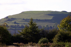
Cley Hill is a very prominent landmark, situated to the west of Warminster..
It is a bi-
There are at least two Bronze Age barrows on top of the hill. The round barrow is the most prominent of the two and is visible in the top right of the photograph. |
|
Just to the south of the hill is the old hollow way that once linked Warminster with Corsley before it was replaced by the Frome Turnpike (A362) sometime after 1757. A public footpath still follows much of its length from Bugley to Witbourne Springs near Corsley. It is well worth a walk.
Cley Hill is owned by the National Trust and is open to the public free of charge, 365 days a year. A small car park is accessible from the A362. | |
|
|
|
|
Scratchbury Hill |
More pictures here |
|
|
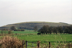
To the east of Warminster, near Heytesbury is Scratchbury Hill or Camp. Apparently Scratch is an old name for the Devil.
This hill fort is uni-
|
|
Ordnance Survey maps show several tumuli within the ramparts, but only one is prominent today. This is a typical Bronze age round barrow situated on the south west of the hill just within the ramparts, not on the crown of the hill. This makes it a prominent landmark from the Wylye valley floor and suggests that this position was carefully chosen.
Although this hill fort is private property, the Wessex Ridgeway passes along the northern ramparts. There are no car parking facilities. | |
|
|
|
|
Battlesbury Hill |
More pictures here |
|
|
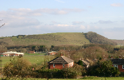
Just a mile or so to the west of Scratchbury is the hill fort of Battlesbury. It is a more impressive monument than either Cley or Scratchbury.
This is a bi-
|
|
Recent excavations by Wessex Archaeology have revealed an Iron age settlement on the ridge joining Battlesbury to the rest of Salisbury Plain. This settlement appears to have gone out of use at the time the hill fort was built. More information is available from the Wessex Archaeology website: http://www.wessexarch.co.uk/projects/wiltshire/battlesbury/index.html
Battlesbury also contains a Bronze Age round barrow. This is sited close to the southern ramparts and, although a coppice of trees now blocks the view, it would once have been a significant landmark when viewed from the Wylye valley floor.
As at Scratchbury, the Wessex Ridgeway passes along the ramparts (the southern ones this time), but car parking is still sadly lacking. | |
|
|
|
|
Further reading |
|
|
"Iron Age Communities in Britain"
'"Wessex to A.D.1000"
"Ancient Britain"
"Hill forts of England and Wales"
"Maiden Castle" |
by Barry Cunliffe, Book Club Associates, 1975.
by Barry Cunliffe, Longman, 1993.
by James Dyer, B.T.Batsford Ltd, 1990.
by James Dyer, Shire Archaeology, 1981, 1992.
by Niall M Sharples, English Heritage, 1991. |

of page