
|

 Towards Hybrid Analysis -
Specification of High Level Analytical GIS Operators
Towards Hybrid Analysis -
Specification of High Level Analytical GIS Operators 
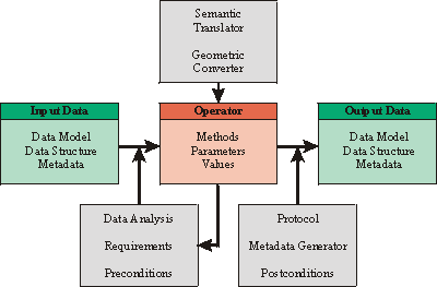
| Input Data | The input data are described through a data catalogue including its metadata and lineage information. The link to their digital representation in the related and implemented data schema has to be known. |
| Operator |
The operator is defined by a generic method. This is specified by its characteristic
parameters. The operation is described by the operators metadata. The operator
generates specific metadata as a protocol for the lineage.
The underlying control has to select the correct algorithm that fits the types and structures of the input data. Each algorithm has its own profile. The process control executes an analysis of the data as an inquiry for the right algorithm. The operator is designed in a polymorph way which includes hybrid operations. |
| Output Data |
The output data are mapped into a data catalogue which may already exist, or has to
be newly generated or extended. It includes metadata and lineage information. Its
representation is linked to the underlying data schema.
The output data catalogue may be derived from the operator, or the operator has to meet the conditions of the data model chosen by the user. |
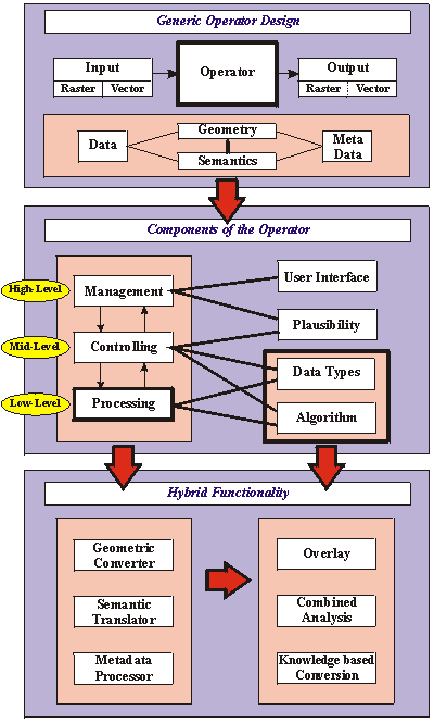
The functionality of a GIS-Analysis-Operator can be modelled by the following three categories: geometric converter, semantic translator and metadata processor. Each category concerns different kind of data.
| Geometric Converter | All geographic data have a geometric component. One of the main goals of spatial analysis is to solve geometric (metric and topological) questions. Generally a GIS analysis produces data with new geometric information. Consequently a GIS-Analysis-Operator converts the geometric input into the new geometry of the output data. |
| Semantic Translator | The semantics of the data is given by the Information Community, its conceptual model with all its attributes and descriptions. It is an overlay to the underlying geometry. The geometric process of the operator is linked to the thematic component of the data, a new theme is generated during the combination process with the geometric and semantic overlay. The result is a new semantics. |
| Metadata Processor | The Operator is controlled and prepared for the processing, based on the metadata of the input data. The metadata is translated to process control parameters. The process produces new metadata. The generation of the output metadata is controlled by the operations metadata. |
The controlling of the operator includes the preconditions that are derived from the input data and the chosen operation with its implemented algorithms. For the output, the postconditions include the requirements of the output data. The operation has to be protocolled including the lineage and other metadata.
 Different Abstraction Levels of Analytical GIS-Operators
The technical implementation of the described conceptual design of analysis operations asks for concrete solutions. Therefor the operator is divided into three levels of abstraction. The design is a top-down concept because of its user-oriented and user-friendly approach. At high level, concerning the management , the operator works with metadata only. It is this level which the user is faced with. At mid level, the control of the operations, including the handling of the data types and the metadata, is performed. At low level, the algorithms are processed and protocolled.
The universality of an operator is displayed at the highest level of abstraction because of its design which is independent of data structure and data schema. The interactions between the levels directly concern neighbour levels because of their hierarchy. The core of such a universal operator is at the control level. The performance of the operator is carried out at the processing level.
|
Management
(High Level ) |
At high level, the semantics of the operation is defined. The data to be analysed are
selected from the data catalogue with their associated metadata. The operator is
specified upon its parametrisation which is also metadata driven. This level manages
the whole operator. It is the constituent part of the analysis task. The user defines
the operation upon his cognitive experience.
The data description at this level is independent of any spatial data structure (e.g. raster or vector) or data schema. |
|
Controlling
(Mid Level) |
At mid level, the controlling of the operation is carried out. The input data, selected
at high level, are linked to their corresponding data representations in a geometric
and structural level. The operator analyses the metadata, given at the management
level, and chooses the algorithm that matches the data types and other
requirements. Here, the requirements for hybrid analysis functionality arise because
of the different data representations.
At this level, the cognitive semantics of the data and operation gets lost, the information is translated into syntactically structured information for the processing in which their cognitive context is unimportant. |
|
Processing
(Low Level) |
The low level is the processing level. The algorithm processes the data numerically, all operations characteristics are processed and sent back to mid level. |
Specification of Analytical GIS-Operators
Based upon the operator design described above, the specification of a generic high level spatial analysis operator is necessary to create instances of an operator class "high level-operators". An instance of that class could be any high level operator, e.g. buffer, overlay, shortest path. At the current state of development the specification introduced in this section does not claim to be complete or formal in mathematical terms. It rather serves as a more detailed description of components in order to approach to a formal specification. It is the attempt to outline the general conditions necessary to create high level operators. Therefore it has to be regarded as a step towards the realisation of operator design.
The variety of instances of high level operators, design and specification comprises different aspects. The data structure independence of the management level has to be implemented through a data type driven polymorphism at the control level. Due to the polymorphism a high level operator is able to execute different algorithms or sequences of algorithms at the processing level.
In addition, cognitive and semantic aspects can not be neglected in operator design. Yet the structure of data plays a central role in the building process of high level operators concerning different parts of the specification.
User Interface
The user interface specifies what kind of interaction can take place between the user and the operator. User interaction includes any form of communication between the user and the operator, such as:
| operator control |  Selecting data through a data catalogue
 Input or determination of parameters for the operator
 |
| user support, documentation |  Access to documentation and description (metadata) of operations and data
 Transparency of the operator by describing architecture and algorithms
 |
| process control, messages |  User comfort with messages and warnings
 Error-control
 |
Plausibility Control
Plausibility control of an operator should be able to determine whether an operation proves to be meaningful or not. Representation of this advanced form of semantics has to be one level above the creation of the correct data type management. It comprises several aspects.
| Semantics Control | Analysis and comparison of semantics in input and output data should enable the operator to distinguish between allowed and forbidden combinations. Predefined semantic results for given input/output combinations could also be attached to the operator ( semantic templates). |
| Property Control | A relation between geometric and semantic properties of data should be established. For example, geometric accuracy control should decide which combination of different resolutions is allowed. Tolerated ranges of accuracy for different semantics of spatial data can be supplied. |
| Lineage Control | Lineage information attached to output data could include plausibility control documentation and results. |
Types
Assumed that spatial data are organised in data types, it has to be exactly specified which data types can be processed by an operator and which data types will be produced by the operator after processing. Data types distinguish between different representations of geometry within spatial data.
| Catalogues |  Specification of allowed data types and its definitions
|
| Combinations |  List of input-output-couples (combinations of input and output data types related
to an operator)
List of input-output-couples (combinations of input and output data types related
to an operator) |
| Restrictions |  Restriction for operator use with regard to the allowed data couples
 |
 data model (topological vector model, task specific models, ...)
 structures (raster, vector, tin ...)
Polymorphism
Polymorphism stands for different algorithms related to different data types of the same high level operator. Program structures are created at the control level by decisions made according to data types, user parametrisation and semantic specifications. To include conditions have to be fulfilled:
| Uniqueness |  Non-ambiguous decision rules
 |
| Completeness |  A function must exist for every combination of allowed input data
 |
| Correctness |  A method to test consistency and correctness of decision rules
 |
| Extensibility |  Operations at control level must be extensible to new data types and new
algorithms
Operations at control level must be extensible to new data types and new
algorithms |
Algorithms
At processing level standard software development guidelines have to be regarded. It is planned to choose an object-oriented approach with certain advantages related to the described operator design.
| Transparency |  Transparency of algorithms by documentation
 |
| Uniqueness |  Avoiding identical processing and geometric results for different high level
operators using the same algorithm
Avoiding identical processing and geometric results for different high level
operators using the same algorithm |
| Redundancy Free |  Non-redundant implementation of algorithms (modules, function libraries, etc.)
 |
Application Specification
Optional is an extension of high level operators towards the restricted and/or expanded use in certain information communities. That would require:
| Limitations or Reductions |  Restriction in functionality according to a reduction of defined operations in
addition to the specifications mentioned so far
Restriction in functionality according to a reduction of defined operations in
addition to the specifications mentioned so far |
| Specialisation |  Specialisation of certain operators through the input of domain specific data and
functionality (e.g. integration of domain specific rules and algorithms)
Specialisation of certain operators through the input of domain specific data and
functionality (e.g. integration of domain specific rules and algorithms) |
Metadata
Metadata is used to manage all operators at the highest level of abstraction. At the interface or management level, only metadata control user interaction. Explicit and implicit metadata are analysed to control the operator at mid level. The metadata have different meanings at the three levels as described in chapter ??.
In the following, the processing of metadata for high level-GIS-operators is divided into two parts: metadata of spatial data and metadata of the operator.
Metadata of Data
The metadata describe the data at a high level of abstraction in a data catalogue with its related information. The information is the link to the database and to its data schema in which all other information is stored implicitly.
|
Management
(High Level) |
The metadata of the data describe the content and the conceptual organisation of the data. |
|
Controlling
(Mid Level) |
At mid level, the semantics of the metadata of high level has no meaning. The
information of the data types, in which the data are represented, mainly important for
the control of the respective polymorphism. The main aim at mid level is the control
of the structural information of input and output data. This includes the control of
the polymorphism of the operator.
The operator transforms the semantics of the metadata to parameters used for processing, whereas the semantics of the data is of no relevance for the parameters of a process. |
|
Processing
(Low Level) |
At low level, metadata focus on the values and categories of the parameters. The characteristic parameters of the operators and its values are instanciated and assigned to the data to be processed. |
Metadata of Operators
The operator metadata control their spatial analysis process. They map and process the metadata of input and output and protocol the operation and the lineage.
|
Management
(High Level) |
The metadata of the operators describe the task, the functional behaviour and the required information. The operators metadata include the semantics, which is related to the data. |
|
Controlling
(Mid Level) |
The operators metadata control the operation. At this level the mapping of the data types to the algorithm of the polymorph implementation takes place. |
|
Processing
(Low Level) |
This level generates the input data for the lineage of the operation which is related to the derived data. |
Hybrid Analysis
Hybrid analysis is part of polymorph implementation of GIS-analysis-operations. Hybrid analysis is needed for the integration of GIS and remote sensing, for terrain analysis (DTMs in raster format with overlay of vector data) etc.
As input data, we have raster and vector data which have to interact correctly. The result of a hybrid analysis are new raster data, vector data or both of them.
Some examples of hybrid analysis functionality
 Fencing off raster processes by the overlay of vector data
 Verification of geometry and attributes
 Transferring extracted geometry from raster to vector
 Transferring attributes from image interpretation to vector data
 Transferring attributes form vector databases to raster data
 Using raster information for determination of uncertainty of vector data
 Equalising Data
The complexity of the hybrid functionality may be shown by the following survey:
| Projecting Information |  geometric overlay
|
| Combined Analysis |  derivation by aggregation
|
| Knowledge-based Conversion |  knowledge-based conversion
|
 semantic overlay
 derivation by interaction
 accumulation by information transfer
 extraction of objects
The full range of spatial analysis may be reached with operations that interact with raster and vector data without the need of conversion. The requirements of hybrid analysis are divided in geometric interaction, semantic analysis and metadata processing.
| Geometric Analysis |  positional location: generating the relation of co-ordinates of
different data and identifying identical positions of geometric primitives
positional location: generating the relation of co-ordinates of
different data and identifying identical positions of geometric primitives
|
| Semantic Analysis |  geometric interpretation: giving new semantics to the data
|
| Metadata Processing |  analysis of metadata
|
 linking geometric features: identifying features covering the same
location
linking geometric features: identifying features covering the same
location extracting and transferring geometry: generating new geometry by
extraction, transfer and interpolation
extracting and transferring geometry: generating new geometry by
extraction, transfer and interpolation thematic analysis: linking, projecting and deriving integrates new
information
thematic analysis: linking, projecting and deriving integrates new
information Combination of geometric and thematic interpretation: combined
analysis of geometric and thematic information
Combination of geometric and thematic interpretation: combined
analysis of geometric and thematic information description of the geometric, semantic and combined analysis
 Description of the semantic analysis
 statistics about geometric overlay
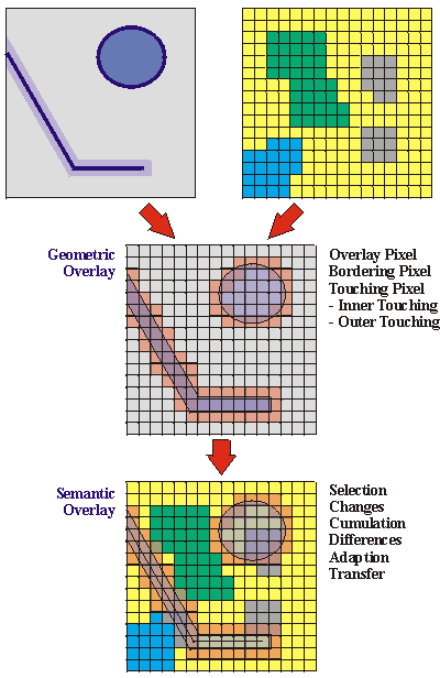
Conclusion
The concept of universal analytical GIS-Operators independent of Information Communities has been outlined and specified. Universality in this context includes a domain independence as well as the aim to work with data . This can only be achieved by metadata driven user interaction.
To generate the aspired data structure independence of universal operators, hybrid analysis techniques have to be integrated. Due to a currently increasing demand for the integration of remote sensing and GIS, hybrid analysis gains significance. Our future work will focus on a detailed specification of hybrid analysis operations and its prototypical implementation.
References
Literature
ALBRECHT J. (1996). Universal Analytical GIS Operations: a task-oriented systematisation of data structure-independent GIS functionality leading towards a geographic modelling language. PhD-Thesis, ISPA Mitteilungen 23, University of Vechta: Vechta, Germany.
FISCHER M., SCHOLTEN H. J. and UNWIN D. (ed.): Spatial Analytical Perspectives on GIS
FORTHERINGHAM S. and ROGERSON P. (ed.): Spatial Analysis and GIS
JUNG S., ALBRECHT J. and EHLERS M., (1997): Multi-Level Comparative Analysis of Spatial Operators in GIS and Remote Sensing as a Foundation for an Integrated GIS, In: FÖRSTNER W. and PLÜMER L. (ed.) Semantic Modelling for the Acquisition of Topographic Information from Images and Maps, SMATI ´97, Birkhäuser Verlag, Basel Boston Berlin, pp. 72-88.
LONGLEY P. and BATTY M. (ed.): Spatial Analysis: Modelling in a GIS Environment. GeoInformation International, Cambridge 1996.
MEYER, B. (1997). Object-Oriented Software Construction. Second Edition. Prentice Hall PTR, New Jersey 07458.
OGC (1996). The OpenGIS Guide: Introduction to Interoperable Geoprocessing, OpenGIS TC Document Number 96-001. Open GIS Consortium: Wayland, MA.
RUMBAUGH, J., BLAHA, M., PREMERLANI, W., EDDY, F. and W. LORENSEN (1991). Object-Oriented Modelling and Design. Englewood Cliffs, NJ: Prentice-Hall.
MapRef - © by Stefan A. Voser; Last Update: 28. October 2001