  |
| Home |Introduction | Books & Papers | Animations | Expansion Sites | Science Links | Download |
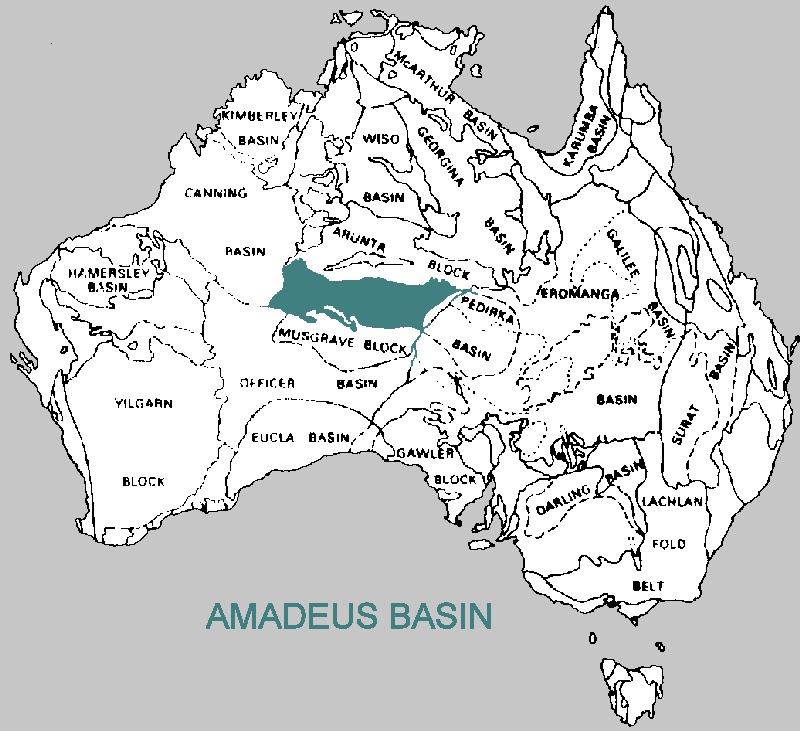
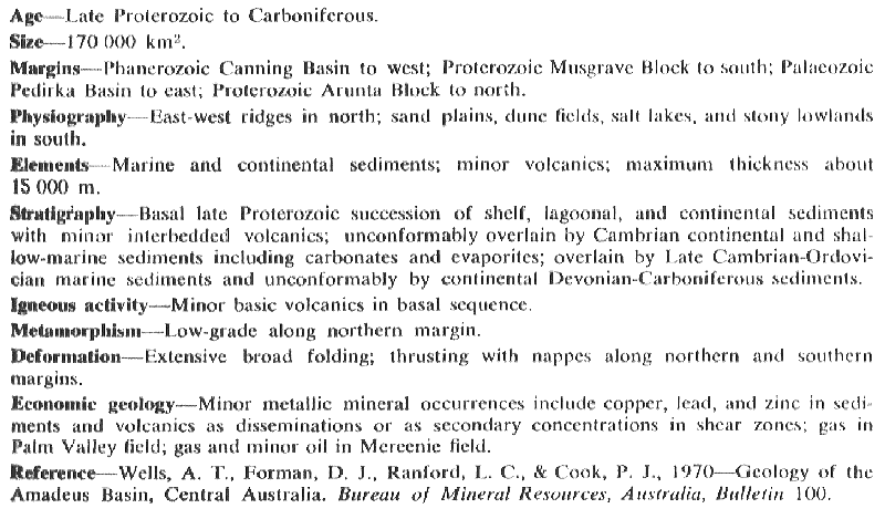
The Amadeus Basin
Maximum sediment thickness
of 15 kilometers containing unconformities of
the Peterman orogeny and
the Alice Springs orogeny.
|
|
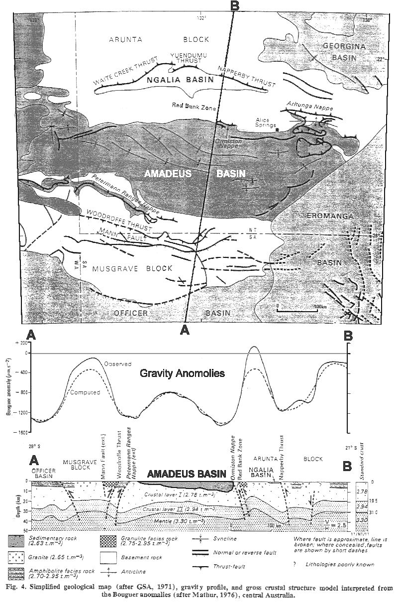 |
The Amadeus basin has come to be viewed as a failed orogenic rift zone and failed to rift on two occasions - the Peterman orogeny and overprinted Alice Springs orogeny. The expansion model predicts that all orogenisis occurs as the Earth's crust stretches apart so a rifting interpretation naturally emerges for the Amadeus basin and other Intra-cratonic orogenic events. Many plate tectonic adherents have unsuccessfully tried to find a compressional explanation for this type of isolated orogenesis. Such Intra-cratonic orogenesis could not be explained by a distant continental collision or subduction event, yet abundant evidence of upper crustal thrust and nappe generation is pervasive within these anomalous orogenic zones.
Nappes and Thrusts - crustal
compression or crustal extension?
If rifts extend the crust, how can large numbers of supposedly compressional thrusts and nappes be generated? Intra-cratonic orogenesis provides unambiguous evidence that the mere presence of thrusts and nappes should never be assumed to indicate full crustal compression.
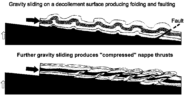
On the contrary, nappe thrust generation never requires or implies whole crustal compression. Thrusts and nappes can be generated by gravity sliding away from an uplifted orogenic core within a gross crustal extensional context. Nappes are generated due to the massive squeezing weight of the sediment pile above them and gravity induced movements, downslope. As uplift proceeds, sediments laid down in deep subsiding basins during the onset of orogenesis (crustal thinning), become tilted and slide downslope on a decollement interface. Decollements usually (but not always) occur within less competent layers of rock which may be lubricated by pore space fluids or hydrated minerals.
Nappes
develop their deformed and compressed features due to their massive
weight and progressive downhill movement which can be for many tens of
kilometers. The simple 2-D diagrams illustrated here have been idealized
to display this concept.
 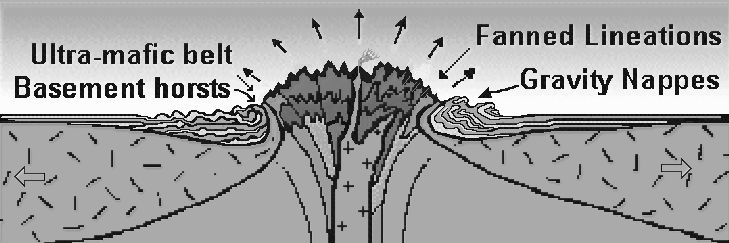 |
The above extrusion diagram
is an idealized symmetrical orogenic model but real-world orogenic symmetry
is almost never observed. Asymmetric extrusive gravity spreading is the
normal mode of orogenesis as demonstrated in the more complex figure below.
This displays a typical pattern of multiple extrusive nappe generation
and overprinting.
Take particular note of the vertical "root zone" of
the nappes. Nappes typically display evidence of extrusion from a
vertical source or orogenic core zone.
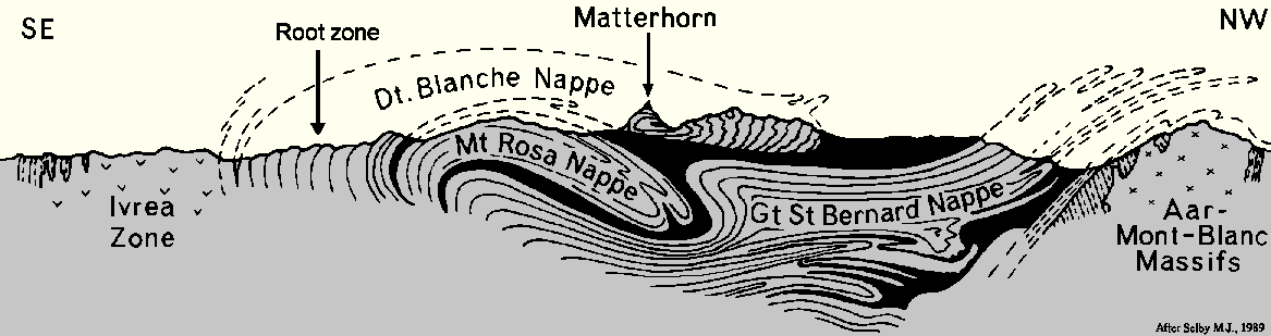 |
When nappes reach a flat stable surface or when friction inhibits further movement they become immobile but may be "re-activated" by further uplift or by being pushed from behind and overridden by successive extrusive nappes. Nappes often run into the back of each other and what results is a stack of intensely compressed large-scale folds and thrust faults, but there has not been any full crustal compression or crustal "shortening" during their formation. Nappes and thrusts can be indicators of gross crustal extension.
Only the upper portion of the crust is crumpled and "compressed" by the downhill pull of gravity (to around 10-15 kms depth - often less) but the rest of the crust extends below the decollement surface. The only thing nappes and thrusts indicate for certain is that intense regional uplift has occurred. All orogenic deformation features can be potenially explained by gross crustal extension. Crustal compression is not required to generate folds, thrust faults or compressional rock deformation textures. Rock deformation textures do not indicate whole crustal compression irrespective of deformation or pressure/temperature plot. Deformation textures only indicate that deformation has occurred. They never prove nor even indicate that whole crustal compression has occurred during their development. Crustal extensional diapiric orogenesis combined with surface curvature adjustments easily account for all observed deformation features and metamorphic petrologic parameters.
Extensional Tectonics
Standard plate tectonic interpretations of the Pacific "rim of fire" orogenesis can be completely re-interpreted within an extending crustal and mantle context and still account for all of the compressed deformation features found within circum-Pacific orogens. This model also explains the Himalayan orogen with out continental plate collision.
Orogenic uplift and deformation implies an increase in the crust's gross tension field. Indeed, how could enormous volumes of intrusive magmas intrude the crust if the crust was being greatly compressed? Are not regional dyke swarms extensional crustal features? Plutonic intrusions can not intrude the crust if room is not available for them to do so. Crustal compressional stress would of course rapidly seal magma conduits and seal up magma chambers.
These igneous features (intrusive and extrusive) indicate that "room" has to be made for them during orogenesis and strongly implies that all orogenesis grossly extends the crust. No whole crustal compression occurs during orogenesis--only uplift and further local extension on an asymmetrically expanding globe.Excess crustal tension is initially relieved during orogenesis, firstly by stretching, thinning and heating the crust which produces a slowly subsiding sedimentary basin that often forms a relatively shallow sea, depending on the level of crustal tension. Very thick sediment piles are deposited within these basins. This stage of the orogenic cycle is then followed by tectonically violent vertical through crust diapiric uplift and associated whole crustal heating and faulting. The basin sediments are lifted vertically and may be metamorphosed by rapidly ascending hot lower crust and mantle melts and fluids. The top of Mount Everest is capped with limestone that was uplifted by more than ten kilometers.
The
idealized basic orogenic model displayed below (after Carey, 1996) accounts
for virtually all orogenesis and rift formation.
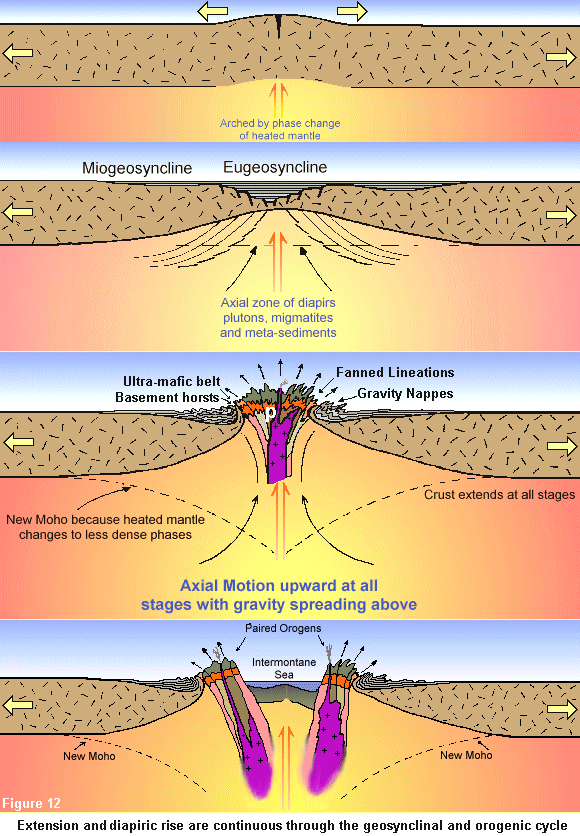 |
Subduction has not occurred and is not required to explain the tectonic features of active margins. Compressional orogenic theory is an unnecessary barnacle of subduction theory.The Amadeus basin's rift events "failed" because the Earth had not yet entered its' current rapid growth stage on the exponential inflation "J-curve", when they occurred. Large ocean basins did not exist during the late Proterozoic and did not start to develop large area until Mesozoic times. What did develop prior to these ocean basins, were large slowly subsiding sedimentary epi-continental basin seas. This was the tectonic environment of deposition for global occurrence of Carboniferous to Permian coal measures. Crustal tension was highest in areas of mantle injection, causing orogenic rift belts to develop and narrow intermontane seas within the central rift zone.
This is what occurred within central Australian orogeny as it did also on other continents. Rifting of this type caused the eventual dispersal of continents which never were part of an actual super-continent surrounded by a vast ocean. The Earth's crust was originally a single contiguous plate that covered a planet around one half its' present radius. The continents formed as a rifted mosaic of crustal plates. These proto-continents were divided by narrow rift seas (proto oceans) which formed interconnected networks of narrow sea lanes after the style of the current, but smaller Mediterranean sea. In time, the rifts widened as Earth's exponential expansion rate rapidly increased during the Mesozoic. The once contiguous global "continental" crust dispersed into separate continental plates and smaller fragments at this time. As these continental fragments dispersed, they were separated by a new lithospheric feature--basaltic oceanic crust and the ocean water and atmosphere which out-gassed from the mantle in proportion to the formation of new continental and oceanic crust. Most of Earth's rifting now occurs far away from land in deep oceanic basins. This occurs because of the greatly speed up rate of exponential expansion which causes the generation of denser mafic oceanic crust from the top of the mantle due to deep mantle rise and upper-most mantle melting.
The geochemical evolution of the atmosphere, and a rapidly growing hydrosphere in shallow epicontinental seas and rift basin, greatly ameliorated and stabilized environmental conditions on Earth. This sponsored the beginning of the on-going phanerozoic era of complex vertebrate land based life and increasing biological complexity through time and the geological responses to this explosion of life.
The model described here also offers a framework to explain several other significant geological issues such as the incremental formation of cratonic crust throughout geological history and the geochemical changes to rock forming minerals through time and sedimentary facies distributions.
When mid ocean rift centers
are analysed within the plate tectonic theory, the resulting tectonic interpretation
implies that mid-ocean-ridges are migrating across the ocean basins.
This is a major problem for the plate tectonics model because no one can
adequately explain why or how these global rift zones could move and yet
still produce a symmetrical production of new ocean crust and transform
fault off-sets as they move. But again the inferred movement is a
theoretical artefact of the subduction assumption because when these mid-ocean-ridges
are viewed within the expansion context they are not migrating across
the mantle and all of their features become explainable.
Continental Lineaments
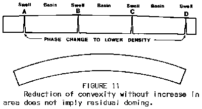
Another outstanding geotectonic paradox which is solved by global expansion tectonics, is the observation of dozens of continental-scale lineaments throughout the Australian craton--and within other cratons.
These lineaments have eluded plate tectonic explanation, but are wholly
expected and predicted within the Global Expansion Tectonics paradigm.
They are caused by lithospheric curvature convexity reduction as Earth's
radius increases (see figures below). This process explains how continental-scale
lineaments can simultaneously cross-cut some of Australia's most ancient
and also, most recent terranes--all within the same 'lineation' but with
no other observable or implied structural linkage.
|
Compilation and Review of Australian Lineaments Project Leader: Dr Simon Cox, CSIRO
Summary It has been suggested that a number of large scale linear features can be recognised in remotely sensed visual and geophysical images, and in some compilations of geological data, within the Australian continent. Some of the lineaments are stated to have a fundamental tectonic significance. It has been further claimed that these lineaments, and their crossing points, coincide with the occurrence of mineralisation sites, particularly major mineral deposits. Objective or statistical methods for consistently identifying these features have proved difficult to develop. It appears that much reliance has been placed on pattern recognition by humans. Evidence of a consistent physical expression for these lineaments in the rocks within the crust has not been forthcoming. Furthermore, there has been no explanation of the role they may have played in processes associated with the building of the continent which is consistent with modern tectonic concepts. This leaves important questions outstanding: Are these lineaments real? Do they have a consistent correspondence to structures in the crustal rocks? What role do they play in the geodynamic makeup of Australia? What relationship do they have with the location and development of mineral deposits? |
 |
The above figure shows the effects of convexity adjustments upon the
lithosphere (particularly continental lithosphere) Note the
greater extension in the lower crust and that intrusion pathways are opened
up for a plethora of potential geological phenomena to be generated without
any substantial horizontal motion. This is also a source of permanent weakening
of the crust for later 're-activation' events. Figure from:
Carey, S.W., 1983: The necessity for Earth expansion. pp.375-393 in Carey,
S.W. (ed): Expanding Earth Symposium, Sydney, 1981, University of Tasmania.
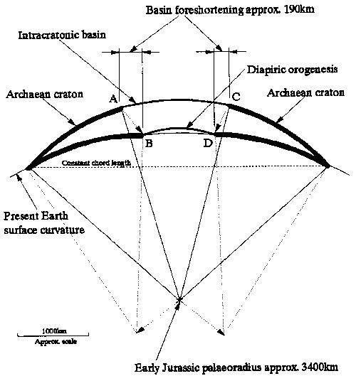 |
This figure shows the mechanisms of intra-cratonic basin 'foreshortening'
during asymmetric expansion of the Earth. In this example, basin
foreshortening amounts to approximately 190 kilometres, giving rise to
('apparently'
compressional) diapiric orogenesis. (In: Maxlow
1999)
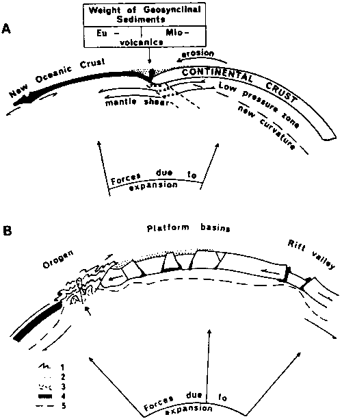 |
The above shows the effects of curvature changes: Rickard's (1969) model for development of a "geosynclinal trough" prior to orogenesis. Figure A represents a "critical stage" of development where tangential shear is balanced by the strength of the crust and downward acting weight of the sediments and; Figure B represents orogenesis, where terminal tectogenesis is induced by rising geotherms and granitic magmas. (From Rickard, 1969) (In: Maxlow 1999)
Study the animations, particularly the North, South and East Pacific basin. You will notice the growth of ocean basins is asymmetric and there is no mid ocean ridge currently within the central pacific basin. You will also notice that the quantitative magnetic isochron dataset clearly shows that that the locus of crustal growth is active in one area for a time, then the area of spreading relocates to an area where the global tension field is greater.
In the north Pacific, new mafic crust is currently forming at the Eastern and Western margins. A similar pattern has also developed in the South pacific as well. The pacific ocean is rapidly growing at it's margins and also in the southern ocean. It is not rapidly shrinking as should if the plate tectonic model were valid, These animations conclusively illustrate the incompatibility of subduction fairy-tales with real-world quantitative magnetic isochron data.
Collisional and convergent accretionary orogenic theories, which all imply large global horizontal plate drift motions and mantle convective overturn, are never required to account for the observed geotectonics of the entire Earth.
