 |
| Home |Introduction | Books & Papers | Animations | Expansion Sites | Science Links | Download |
The Earth
A dominant meme a century ago was the Principle of Uniformitarianism - that the present is the key to the past, that geologic history proceeds from understanding existing processes and phenomena. Dogma taught the permanence of continents and oceans, endless cycles of volcanism, mountain-building, erosion, and sedimentation, extending far into the unknowable past.
Such uniformitarian ideas go back to Xenophanes, 604-540 B.C. of the Ionian school, who had correctly interpreted sea shells and fish fossils far from the sea as the remains of extinct creatures. Herodotus, also in the fifth century B.C., understood the formation of deltas by current processes and estimated that it would take some ten thousand years to fill up the Red Sea if the Nile opened into it.
Nevertheless, Archbishop James Ussher in the early seventeenth century, believing absolutely the truth of the Bible, taught that the marine fossils, dug up from time to time high in the mountains, had been inserted by the devil to test the faith of believers, or deposited by Noah's flood, or perhaps left by itinerant travellers partial to a shellfish diet, and that the Earth itself was created in the year 4004 B.C.
He was generally believed by the contemporary establishment. But half a century later Robert Hooke, concerned with the winning of coal, built up sound concepts on the origin of sedimentary rocks and the fossils in them, based on his observations of currently observable processes.
In the mid-eighteenth century, Compte de Buffon wrote:
Astronomic cycles, such as Earth's daily rotation, annual orbit, Chandler's 13-month wobble, 11-year sunspot cycle, 19-year nutation, 26,500 year precession of the equinoxes, the 661-year oscillation of the Sun's position resulting from the sum of the attractions of the planets, and probably a 300-million-year cycle of the Sun's orbit around the galaxy, are all essentially uniformitarian processes.
If Sun became a nova or a cepheid variable, that would be the end of Earth, and that certainly has not happened during the past four billion years; but I will suggest in Chapter 6 that a solar nova did give birth to the solar system, and that in the remote future Sun may become a cepheid. But we do know that Sun is a variable star in a minor way, and we should be alert for evidence of any solar variation in the geologic record. So far we have not detected any, although some authors have suggested that solar variation may be involved in the glaciations every 300 million years or so, or in the recurrent evaporites and red beds.
Gross unique events affecting us would have to be astronomic. We must ever be alert to detect or suspect a major astronomic event in our reading of the geologic record, perhaps the acquisition of the Moon, impact of a major asteroid or comet, disintegration of the postulated asteroidal planet, explosion of a "nearby" supernova, or whatever.
Many geologists believe that a large meteorite hit Earth nearly 70 million years ago, left iridium traces around the globe, extinguished the dinosaurs, and caused major changes in living things generally. Others have postulated similar events to account for other abrupt steps in the fossil record. "Abrupt", however, needs definition. Wezel showed that there was not one but several iridium peaks. Apparent abruptness may only be due to telescoping of time, viewed from 70 million years later. The Tollmanns (1993, 1994) have argued that the Noah flood was a real event some 10,000 years ago, recorded in the strewn fields of tectites and oceanic spherules, and in legends of many peoples around the world.
Certainly several asteroids of considerable size regularly cross the Earth's orbit, and in the long run catastrophic collisions are inevitable. The 46 asteroids of the Apollo family, the seven Atens and at least some of the 47 Amors (Chapter 6), intersect the Earth's orbit twice each time round. But the mere fact of repeated intersections of the Earth's orbit, does not necessarily imply ultimate collision. Asteroid Toro crosses our orbit in January and August, and of course the Moon crosses our orbit twice a month (Figures 119 and 120).
De Buffon and other advocates of uniformitarianism had in mind the observable day to day and season to season processes. But this is anthropomorphic. More profound effects come from the great Krakatoa explosion of 1884, the great Aleutian tsunami of the first of April 1946, the violent hurricanes of the Gulf of Mexico, the Lisbon earthquake of 1755, the prehistoric deluge from the collapse of Montana's Lake Missoula, the massive volcanic outburst of Vesuvius which destroyed Pompeii in A.D. 79, or the still greater Aegean eruption on which Plato created his Atlantis. But there have been thousands of Krakatoas and other "unique catastrophes" since the end of the Tertiary. Ongoing repetitive processes caused them all. On a geologic scale they are uniformitarian.
Although uniformitarianism remains true in respect to the permanence of physical laws, particularly the dominance of gravity, we must now recognize persistent trends, and also unique events. Cretaceous is not a replay of Cambrian, or Ediacaran, or Hadean. Each period, each Eon, has its own flavour.
The angular momentum axis of the Earth remains fixed in space, except in so far as it may be changed by some external torque, but momentum redistribution may have been possible within the solar system.
Redistribution of mass within the Earth, which displaces the axis of the moment of inertia, first causes axial wobble then a migration of the pole over the surface (distinct from a precession which is only caused by an external torque and does not alter the position of the polhode). But after internal mass redistribution - for example the opening of a new ocean, or a global phenomenon like the Mesozoic dolerites - the pole migrates by slow internal flow until the Earth rotates about the new maximum moment of inertia.
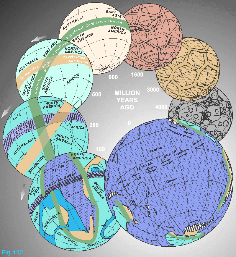
Polar wander over the surface of the lithosphere is probably the most important geologic variable. During the lower Paleozoic, the Caledonian-Appalachian-Tasmanide zone was equatorial (Figure 112). After a 50o shift the Mesozoic Tethyan zone was equatorial; another 50o shift moved the equator to its present position. At each of these times seasonal oscillation [present was] caused by the obliquity of Earth's orbital plane to those of Sun and Moon .
If the spin axis were normal to the Sun's orbital plane there would be no seasons, the poles would enjoy permanent daylight, because the tangential rays of the Sun would be refracted in by the atmosphere. The humid "tropics" would extend to fifty or sixty degrees from the equator. Geology can tell us the position of the paleopole with respect to the lithosphere, but differential motion may occur between lithosphere and mantle and core.
The Early Devonian regression and climatic aridity of the Old Red Sandstone and wide-spread evaporites may have been linked to the Appalachian shift of the equator; the Permo-Triassic regression and the aridity of the evaporites and the New Red Sandstone may have been linked with the equatorial shift to the shift from the Appalachian to the Tethyan equator and the equatorial shift from its Tethyan position to its present position may have been linked with the Late Eocene to Oligocene regression and widespread laterite, bauxite and evaporites.
During the Late Devonian and Early Carboniferous, the obliquity of the lithosphere seems to have been small - there was no glaciation, the zone of steamy tropics extended well away from the equator, and the Lepidodendron and Rhacopteris floras spread across both northern and southern hemispheres to high latitudes.
During the later Carboniferous and early Permian with large obliquity, the tropical zone became very narrow; extensive glaciation occurred, the Glossopteris flora developed in the southern lands bounded by the tropics, while the Gigantopteris flora developed in the north.
By the later Permian, the glaciation had disappeared, more plants began to intermingle, and red, chocolate, and purple shales of warm climate were found everywhere in the early Triassic. In Tasmania at 60oS (as indicated by paleomagnetic data) reptiles lived which could not survive a frost. By the Jurassic, cycad floras and their associates spread throughout to high latitudes. Similarly, in the late Cretaceous, dinosaurs flourished in northern Alaska near the contemporary north pole, and Clemens and Nelms (1993) suggested that they may have been warm-blooded but still could not account for their survival through the months of total darkness, especially without plant food. Perhaps they seasonally migrated long distances. At the same time Vickers-Rich and Rich (1993) described southern dinosaurs well within the then Antarctic circle and raised the same questions.
It seems that polar Australia supported conifers, ginkgoes, ferns, cycads, bryophytes, and horsetails, and a sprinkling of angiosperm pollen has been detected. But was there any annual winter of darkness then? At zero obliquity of the lithosphere, the dinosaurs and the plants they fed on would never face winter darkness, for even at the poles the sunlight would be refracted in throughout the year! George Williams invoked high obliquity to get equatorial glaciation in the Precambrian.
The Eocene also seems to have been a time of low obliquity, but from the Oligocene on, obliquity increased, glaciers appeared in Antarctica and Tasmania (Macphail et al., 1992), laterite and bauxite retreated before the cold climate, and tropical rain forests retreated from latitudes 50o to 25oS.
The starting assumption has been that the present status of Earth, the solar system, the stars, and the Universe, is the normal status. Hence as more than half the present Earth is ocean, major oceans are assumed to have always dominated the Earth. But, on the contrary, I have argued (1958-1988) that no great oceans existed before the Mesozoic, that exponential radius expansion has occurred through-out geological time, and that continental crust of Pangea encompassed the whole globe.
The eons of Earth history are not uniform. We can only speculate about the pre-biotic Hadean Eon, because no known record has been preserved. A solid crust, presumably basaltic (the light differentiate of ultramafic magma), had ended the molten stage, volcanic resurfacing was rife; but the water and other out-gassed volatiles escaped, because the mass then (about 1023 kg ?) would not have been sufficient to retain it, although it was adequate to command a spherical shape. The present surface of Moon (oldest dated rocks 4.56 Gy) might be a starting analogue.
Archean Eon: From nearly 4000 million years ago, I imagine a small Mars-like Earth probably already with a differentiated core. Precambrian shields, now the cores of all continents, were the whole surface before their dispersion, far into the future. The first atmosphere to be retained lacked oxygen (later to be produced by plants) or argon (later to be produced by radioactive potassium); water accumulated in shallow basins. Stratigraphers call these subsiding areas, but perhaps lower areas recorded not subsidence but regions of cooler and hence denser rock, that lagged behind the hotter, less dense, diapiric plutons during general Earth expansion.
Basalt, now "greenstone", derived directly from partial melting of the mantle, resemble in their chemistry modern oceanic basalt. Gravity drove the basalt to the surface because its magmatic density is about 2.6, whereas the density of solidified basalt is 3.0, so the isostatic weight of the crust supports a column of basalt magma several kilometers above the surface. Such diapirism implies a tensional environment (Tanner and Williams, 1968)
Mafic lavas formed pillows when they flowed into water. Komatite (greater than 20% Magnesium), unknown from post-Archean rocks, came from deep in the mantle, melting at 1650o C. A dominant igneous rock was bimodal low-K Na-dacite, andesite was rare, and there were scarcely any alkaline igneous rocks: Diapiric granite, richer in sodium and poorer in potassium than later granite, rose like a field of 50 km salt domes through fields of greenstone lavas.
Greywacke shale and sand of igneous provenance accumulated in the basins, immature in that they had not suffered much abrasion or chemical weathering in the thin oxygen-free atmosphere, or in "soil" devoid of humic acids. Figtree Group clay minerals of the Barbeton greenstones of South Africa have been dated at 3.4 Gy (Toulkeridis et al., 1994).
Silica was represented by chert rather than quartz, and as the cherts are usually slightly carbonaceous, with 13C depleted with respect to 12C, early bacterial activity is suggested; that would still leave 1,000 million years before that for random evolution of hydrocarbons to chance on a self-replicating compound. Dolomite was extensively precipitated in some areas, consistent with weathering of a magnesium-rich mafic landscape.
Although Archean rocks are now restricted to small inliers, significant differences against later terranes do seem to be real. There is no suggestion of linear orogenic belts, no typical ophiolites, no blue schists. Fields of circular granitic diapirs seem to be restricted to the Archean.
Mantle-derived simple ores of gold, platinum, chromium, nickel, and cobalt dominated the Archean. Since the beginning of human history, some 92,000 tons of gold have been produced, but 55% of this has come from the limited exposures of Archean rocks (but not from the gneisses) which was redeposited in Lower Proterozoic placers. With the gold are uranium and thorium minerals, and the other "noble" elements, platinum, osmium, and iridium.
Yield of gold from rocks of the next 2,000 million years has been trivial, then it increases slowly again to 35% from the last 100 million years (Woodall, 1988). Clastic-hosted stratiform gold ores, especially conglomerates, in broad epeirogenic basins peak about 1.5 Gy. By contrast, porphyry-copper deposits are scarcely known in old rocks, but rise through the last 200 million years to peak now! (Barley and Groves, 1992). Is depth of erosion a factor?
Nickel ores are strongly era-dependent. Nickel and chromium ores are particularly associated with Komatite, which are confined to the Archean (Hutchison, 1976). Hence, Archean nickel ores are ultramafic-volcanogenic massive sulfides in older greenstone belts, with nickel strongly dominant over copper and with some gold. Proterozoic nickel deposits tend to be mafic magmatic disseminated sulfides with nickel and copper more equal, and no gold. Phanerozoic nickel ores tend to be lower grade ophiolitic nickel silicate deposits, or the nickel is concentrated in derivative garnierite laterite.
Contrary to the expectations of dogma, there is no evidence of horizontal crustal compression in Archean rocks. The granite-greenstone terrains are dominated by vertical tectonics-cylindrical granite diapirs between residual sagging sediments.
Gneisses are common, but gneissic foliation is indicative of flow, not of compression (Figures 15-18); the flow lineation is normally steep, resulting from gravity-driven upward flow. Diapirism only occurs in a tensional environment. Prominent dike swarms also indicate tension. The Archean Eon lasted for half of geologic time, so there is scope for considerable progression of geologic processes within the Archean.
Proterozoic Eon, like the Archean, occupied nearly half of the age of the Earth, but surface area was less than 40% of the present. The Proterozoic was markedly different from the Archean, although the change was transitional rather than abruptly episodic. The atmosphere was now thicker, but still lacking oxygen, so that wind-borne sedimentation led to the great iron formations which occur in all Lower Proterozoic regions, of which more later.
No oceans existed, only lagging, perhaps subsiding, basins which accumulated as much as 30 km of sediment. Volcanic products exceeded secondary sediment by a factor of 3:2, perhaps more. Such deep basins are difficult to conceive except on an expanding Earth; but a rate of radius increase of 1mm/year could easily accumulate such a thickness as a lagging still-stand basin, at all times in isostatic equilibrium, especially when volcanics contribute a large proportion of the thickness. The very broad sedimentary basins characteristic of the Proterozoic indicate pervasive epeirogeny, a gravity-balancing process, not orogeny. Quartz sandstone, derived from the weathering of granite, became increasingly abundant.
All igneous rocks of course originated from the mantle, but in the Archean they were less differentiated, whereas in the Proterozoic they underwent more complete differentiation and hence were much richer in LIL (Large Ion Lithophile) elements such as potassium, rubidium, thorium, lead, and uranium, which do not fit easily into the lattices of mafic minerals, but are more easily accommodated in potassic feldspars and some other silicate minerals.
Granitic diapirs were abundant, but now potassic instead of sodic. The sharpness of the increase in the K to Na ratio has been called by Larin (1993) the "K explosion". The granites were also richer in the rare earth elements (except europium, which went against the trend). The lithosphere received some ten times more radioactive elements and heat generators than the mantle, and the mantle had some ten times the content of chondritic meteorites. Proterozoic sediment was more silicic than in the Archean with abundant quartz, more mature with recycled minerals, and more shales.
Widespread normal faulting and mafic dike swarms, indicators of crustal tension, were particularly notable during the Proterozoic Eon.
Iron ore is very sensitive to oxygen concentration. It occurs in the Archean in volcanic rocks as fine-grained sulfides and oxides (magnetite exceeding hematite), in association with copper, zinc, gold, and nickel. But it dominates in the Lower Proterozoic (see below) as fine-grained sedimentary beds, perhaps originally deposited as carbonates, but now as oxide with hematite dominating magnetite, with total absence of soluble minerals such as copper, zinc, and nickel, but very minor fine gold. Iron ore is quite limited in the Paleozoic as oolitic hematite or siderite sediment, and still less common in the post-Paleozoic, as oolitic siderite or goethite.
Large strata-bound massive sulfide copper-zinc-lead bodies with silver and gold are prominent in the Middle Proterozoic, as at Broken Hill, Mt Isa, and Olympic Dam in Australia, and in Rhodesia, but occur at other times. Pyritic copper ores recur in mafic sheets of various ages.
Phanerozoic Eon: This last 13% of geologic time, differed markedly again. Equatorial orogenesis dominated tectonics, with broad epeiric seas in higher latitudes. But a main difference was the rapid evolution of life, first marine algae, then marine animals with defensive skeletons, then emergence to the land, then the explosive evolution of land plants, the grazers to exploit them, and the carnivores to eat the grazers. Oxygen was the product of the plants; humic acids vastly altered weathering processes; vegetation grossly changed the relative roles of wind and water in surface transport.
Some coal is found in each period since the rise of plants in the Devonian but pan-global coal measures of the Upper Carboniferous and the Lower Permian are unique, not matched in any period before or since. Why? Less decay, or fewer predators?
The Lower Proterozoic age of banded-iron formations and the Permo-carbonifeous age of coal measures contrast diametrically in the total absence of vegetation in the former and the extreme abundance of vegetation in the latter, but they match tectonically in their wide epeiric basins of quiet deposition with a symphony of climatic cycles.
The Upper Cretaceous is quite individual, perhaps caused by the rapid increase in oceans and their widespread transgression over the continents, populated by myriads of chalk-producing coccoliths and globigerinids, which seem to have outrun their predators. Chalk itself is an unusual sediment, quite rare in the stratigraphic column. Chalk is characteristic throughout Europe, the Mediterranean, the Tethys, including North America, also at Gin Gin in Western Australia, although not co-eval because the great inundation was Upper Cretaceous in the northern hemisphere but Lower Cretaceous in the south. With the chalk are flint and also glauconite, and characteristic sea urchins and rudistids.
Another Cretaceous peculiarity is the 30 million years of magnetic peace from the Aptian to the Santonian. During the preceding 30 million years and the following 80 million years, the magnetic poles reversed scores of times, but during that Cretaceous peace, nothing happened! Why? The Cretaceous, from the Aptian to the Santonian, is special.
Lower Proterozoic banded-iron formations, upper Paleozoic coal formations, the upper Mesozoic dinosaurs, Lower Cretaceous chalk, and the great oceans of the last 100 million years are global and unique phenomena, each integrating the specific environment of the Earth at that specific time. Background to them are logarithmic trends - the Earth radius, the ascent of life, and perhaps some astronomic phenomena.
Derek Ager's 1973 book The Nature of the Stratigraphic Record cites other examples of the persistence of individual facies, characteristic of specific times in Earth history, which recur around the world.
[Summary]
At an early
stage [in Earths history], linear tension fractures allowed rise of heat,
thereby reducing the local [mantle and crust] density so that isostasy
produced a mosaic pattern of linear ridges framing broad basins over cooler
denser rock in which water collected, then sediment, and lava. Orogenic
activity - the regurgitation of geosynclines to become mountain systems,
has not been uniformly distributed in time. Statistical plots of isotopic
age against time indicate that orogenesis and volcanism have been markedly
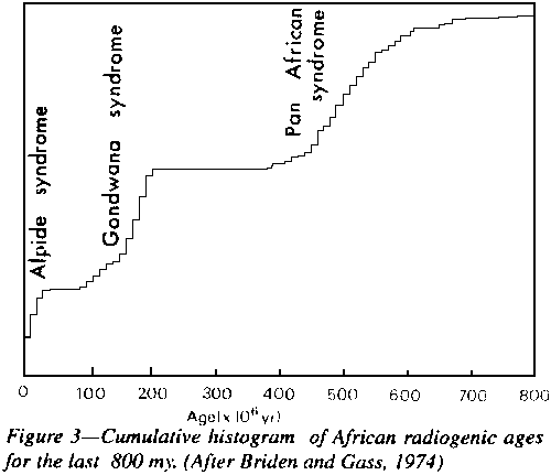
episodic (Dearnley, 1966; Stockwell, l973; and Figure 3).
|
Ratios of 129Xenon (derived from short-lived 129Iodine) to other Xenon isotopes indicate that more than 80% of Earth's atmosphere was out-gassed during the first million years (Allegre and Schneider, 1994), presumably during the early molten Earth when the core and mantle were differentiating.
For the first three-quarters of Earth's life, the atmosphere of nitrogen and carbon dioxide lacked oxygen. The earliest bacterial activity could have been anaerobic photo-synthesis, which produces no oxygen. Weathering and chemical precipitation processes must have been very different throughout the Precambrian. The earliest recorded cyanobacteria which release 02 comes from Western Australian Warrawoona stromatolites (3.52 by.).
Iron freely entered Precambrian water in the ferrous state. In the Phanerozoic, iron tended to remain on land as laterite or lateritic soil. Even in the Cambrian, oxygen was minor, perhaps only 0.2%, compared to today's 20%. The action of living matter, particularly algae, with the photosynthetic absorption of CO2 and release of oxygen, progressively built up our stocks. Cope and Chaloner (1980) concluded that Devonian charcoal implied at least 7% atmospheric O2
Earth is the only body in the solar system with an atmosphere with substantial oxygen-because it is the only body in the solar system with our kind of photosynthetic life. Its effect has been profound, particularly the role of humic acids in the weathering of igneous and metamorphic rocks. Phanerozoic sedimentary rocks were born in water rich in oxygen.
Earthling astronomers tended to assume that oxygen was a normal constituent of planetary atmospheres, instead of only listing gases which demonstrated their presence by spectroscopy.
On Earth, organisms have had to evolve protection against oxygen. Stromatolite colonies probably were important in this. We ourselves spend our prenatal life (where we recapitulate our evolution from a single cell to a complete human) in an aqueous fluid, and in free life oxygen only enters our bodies from the oxygenated wet lining of our lungs. In searching for Earth-type life on possible planets around other stars, the spectroscopic detection of oxygen is crucial.
Before this decade, the general belief was that study of other planets would lead to a deeper understanding of the Earth, particularly our twin, Venus, next to us in orbit, and similar in size, mass, and density. How different Venus turned out to be! Temperature 450oC higher, water 10-5 lower as a fraction of the mass of the planet, atmospheric CO2 102 greater, no atmospheric oxygen, no oceans, no atmospheric weathering or erosion, global fields of tensional faults and graben, universal diapiric volcanism, no "plate tectonics", no compressional tectonics (although interpreters strove to see it). Lacking a freeze-thaw alternation, and without life to yield oxygen, or water to produce rain, rivers and seas, weathering, erosion and sedimentation on Venus must have been very different from on Earth.
Actually, that description of Venus is a fair description of Archean Earth at 80% of her present age! Life had not yet appeared to produce our free oxygen, CO2 had not yet been absorbed by massive limestones and dolomites and by organisms, oceans did not appear on Earth until the Mesozoic (Chapter 6), diapirism, not crustal compression, governs our tectonics (Chapter 3), crustal extension is universal. Perhaps the lack of Venusian water may be caused by her higher temperature and lesser distance from the Sun and hence the easier escape of hydrogen. So Venus does give us a deeper understanding of the Earth, if we take off our blinkers!
Earth is unique in relation to surface water. Mercury and Moon have none. [suspected surface ice was detected recently in a deep crater at the moons south pole] Venus has little total water and no surface water, and no sign of sedimentary strata in the past, but some water may have been locked up in hydrous minerals. Mars has no surface water now, but has evidence interpreted as products of former glaciation and past torrential floods. Elsewhere, I question the validity of this interpretation (pp. 145-146).
The outer planets presumably have abundant water ice. Earth must have lost all primitive surface water and volatiles, but has accumulated water at an exponential rate through volcanic exhalations ever since. Comets are believed to be "dirty snowballs", i.e. mainly water, but water has yet to be found spectroscopically.
Water was already present in Archean rift troughs and broad basin depressions. Many have assumed that the volume of seawater has been essentially constant since early time. On the contrary, Rubey (1951) concluded that the whole of the waters of the oceans had been exhaled, not as a primordial process, but slowly, progressively, continuously throughout geologic time. This makes sense if the volume of the Earth has increased with time. Certainly the rate of emission of water in the present spreading ridges is vast, too rapid to have been maintained at the current rate throughout geologic time.
As the generation of the ocean floors depends fundamentally on the same process as the out-gassing of juvenile water, it would be expected that the volume of seawater and the capacity of the ocean basins both increased in a related way. But not necessarily in phase. There have been times when the capacity of the ocean basins increased more rapidly than the total volume of seawater, with general emergence and widespread regression, on the gross scale of whole geologic periods, or on smaller scales even down to single years, producing diastems in the stratigraphic record.
The Triassic Period, between the widespread seas of the Carboniferous and Jurassic, when oceans flooded the continents, recorded universal regression. Marine sediment was rare except in narrow troughs, and epi-continental seas were shallow with terrestrial or lacustrine sediment, such as the "New Red Sandstone". The Triassic was a period when the total capacity of the ocean basins exceeded the volume of seawater. The "Old Red Sandstone" marks an earlier regression straddling the Silurian-Devonian between the broad transgressions of the mid-Silurian and the Late Devonian.
The great oceans only developed during the later Mesozoic, when they began functioning as major heat sinks, producing cooler atmospheres. The broad epeiric seas of earlier times would have been much warmer than later equivalent areas of ocean. The Triassic reptiles of Tasmania, then at latitude 80oS enjoyed a warmer climate, and may also imply general cloud cover to prevent night freeze after sunset.
Lower Proterozoic banded iron formation (BIF) occurs in epeirogenic basins on all continents - Dharwars and others of India, Hammersley and Middleback regions of Australia, the classical Labrador and Lake Superior provinces of North America, Cerro Bolivar of Venezuela, on the Brazilian shield, Krivoi Rog in the Ukraine, Sveccofennides-Karelides of the Baltic Shield, and extensive deposits in Rhodesia and the Transvaal of Africa.
The BIF is a very special kind of sediment, which was formed in vast quantity, at only one specific time interval in the history of the Earth. BIF is not consistently associated with volcanism, nor with other metalliferous ores. The BIF, with 1014 perhaps 1015 tonnes of iron ore, is one of the most important mineral resources in the world. Banded manganese formations and extensive banded cherts occur with them.
Time distribution of BIF is Gaussian - beginning in a minor way about 3.5 Gya rising to a broad peak at 2.5 Gya, and petering out at 1.5 Gya. Clearly the BIF expresses special characteristics of the Lower Proterozoic environment, which may be accepted as the marker division between older and younger and Proterozoic. Precisely what characteristics caused the BIF to peak during that time interval?
The BIF expresses a specific stage in the development of the Earth's atmosphere, or more specifically, in the development of the Earth's free oxygen. The BIF is preceded by Archean sediments with thorium-rich uraninite and pyrite, so readily oxidized that there could not have been any free oxygen in the atmosphere, or dissolved in the water The BIF epoch is followed by other types of oxidized and hydrated iron ores.
We must differentiate between BIF (sensu stricto), which Gross (1965) called the Superior type, and other less important iron formations, which he called the Algoma type. Redbeds, 2 to 1.9 billion-year-old, with oxidized iron, follow the BIF period. The Silurian Clinton iron deposit, between upstate New York and Alabama (with cross bedding, mud cracks, animal tracks, conglomerate lenses, and 0.9% phosphorus), is quite different from the BIF. Euxinitic pyritic carbonaceous shale without interbedded chert, even when containing enough iron to be ore, is an entirely different facies.
Chemically, the BIF is laminated, alternating iron and silica strata. Aluminum is usually less than 1 %, and phosphorus and alkalis are commonly zero. The iron minerals in BIF as we now find them may be hematite, magnetite, iron silicates, siderite (more rarely ankerite, dolomite, and calcite), and of course hydroxyl derivatives when hydrolysed.
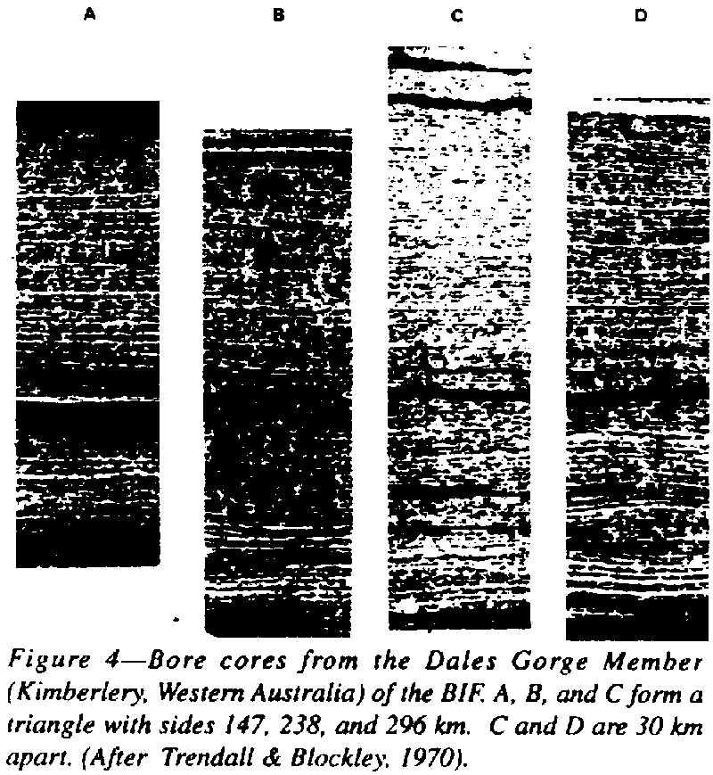
Characteristic
of the BIF is their cyclic stratification on a hierarchy of scales - megacycles
on a scale of hundreds of meters, enclosing macro-bands on a scale of meters,
meso-bands on a scale of centimeters, and circadian micro-bands on a millimeter
scale - all of which may be correlated between drill holes hundreds of
kilometers apart (Figure 4), and hopefully eventually between continents
(see Trendall, 1965, 1966, 1968; Trendall and Blockley, 1970; Huebschmann,
1972).
 |
The source of this silica-iron oxide micro-banding has not been adequately explained. Garrels (1987) said that the origin of the banded iron formation has remained enigmatic. The silica bands were colloidal precipitates, not clastic sediments - there is never the accessory heavy minerals normally expected.
Over a century, dozens of geologists have endeavoured to explain the BIF, with hypotheses including magnetic, volcanic, replacement, and cosmic phenomena. Since James' 1954 paper, BIF is usually explained in terms of chemical and bio-chemical precipitation from seawater, a quaint survival to this day of Wernerian Neptunist dogma.
Seawater is quite incapable quantitatively of transporting in solution such large quantities of iron and silica from local sub-aerial sources to deposition sites (Kaplan, Emery, and Rittenberg, 1963). Some geochemists have cited [Fe3+ H Si 04]2+ as a stable ligand with an overall composition not unlike jaspilite in the Precambrian sea, saturated with silica owing to the absence of consuming organisms. Theoretically perhaps on a local scale, but the abrupt silica-iron lamination repeated thousands of times correlated over whole provinces is surely absurd.
To switch on and off the hierarchy of cycles synchronously over continental areas, perhaps even globally, is incompatible with the Wernerian explanation. Even Maxwell's demon would be unable to achieve such a circadian result!
Overlooking the five orders of magnitude difference in scale, liesegang banding has been suggested as the cause of micro-banding. But imagine such liesegang lines creating the meso-bands and macro-bands, as well as the micro-bands, faithfully over hundreds of kilometers!
Successive reviewers of the voluminous literature have all agreed that no viable solution has yet been offered. The sticking points have been:
(1) Universal alternation of two so-different precipitates, one silica, the other dominated by iron.
(2) The precise correlation of this banding through long distances.
(3) The impossibility of impulsively concentrating such vast tonnages of iron over such vast areas.
(4) Repetition of this special BIF facies on every continent in a narrow Early Proterozic time slot.
(5) the specific chemical constraints: Al less than 1 %, alkalis near zero; P, V, and As all very low.
Nobody before me has suggested pan-global wind storms, which automatically satisfy all those constraints. Not repeated impulsive substitution of contrasted precipitations, but steady colloidal silica sedimentation, abruptly interrupted by recurrent staccato wind storms.
The dilemma arises solely from failure to realize the nature of the environment at the end of the Archean. The BIF has no modern analogues, but faithfully expresses its own specific environment - no vegetation, olivine-orthopyroxene landscape, pan-global winds, no free oxygen, no oceans, global broad basins.
Before the advent of land plants in the middle Paleozoic, the land surface was as bare as that of Mars, and wind was the dominant carrier of fragmental material.
During the Early Proterozoic such dust storms several kilometers deep, would have become pan-global, like the dust storm which obscured the whole of Mars at the time of the arrival there of Mariner 9, which even totally obscured the great volcanoes such as Olympus Mons. The whole planet resembled Venus!
A modern less extreme analogy is the Great Stony Desert of central Australia, where everything finer than grit has been blown away by the wind, leaving behind a vast bedrock desert strewn with wind-blasted stones ("gibbers" in the vernacular). Beyond these ablated "gibber plains", longitudinal sand dunes extend for hundreds of kilometers downwind, composed of .sand grade particles only, which skip before the wind. The pebbles have been left behind, and the silt and clay grades have gone on farther with the wind. For hundreds of kilometers downwind from the sand-ridges is the "bull-dust" country - really a tropical loess consisting only of silt-grade particles, which wind turbulence lifts high in the atmosphere, advancing as a dust-storm front, occluding the Sun, until the atmospheric turbulence subsides, where a loess-like silt deposit accumulates. The clay-grade particles remain in the atmosphere until washed out by rain, perhaps thousands of kilometers farther on-central Australian dust reaches New Zealand!
Over land, such loessic silt would be picked up again and again by the next turbulence, and never settle permanently. But over water, silt would be continuously lost from the base of the dust cloud, and spread throughout the basin, and any other basins downwind, as a single thin time-marker lamina, punctuating the normal steady pervasive colloidal silica sediment.
Hence individual laminae correlate precisely over hundreds, perhaps thousands, of kilometers with the same reliability as the correlation of the wind-borne montmorillionite laminae throughout the Cretaceous of Wyoming. The staccato razor sharp change from the ambient sediment to a dust-storm iron-rich lamina, and back again, iterated endlessly, is the automatic result. Paper thin micro-bands may be a daily repetition.
In the oxygen-deficient Late Archean atmosphere, moist, and rich in carbon dioxide, carbonates such as siderite, ankerite, dolomite, calcite, and rhodochrosite, would have been normal weathering products from mafic rocks, which dominated the surface.
In the "gibber" sand-blasting stage and the dune-transport stage, such carbonate would be subject to repeated fracture to small silt-size cleavage grains, and would form a large proportion of the dust-storm load, notwithstanding its 3.89 density. The more-perfect cleavage of calcite as compared to siderite might tend to partition off calcite toward the clay-sized fraction.
The voluminous BIF literature avoids the origin of the manganese, although many geologists have puzzled why some BIF has little, whereas other BIF has manganese distributed throughout. Varying amounts of rhodochrosite dust is a logical feature of the carbonate dust-storm paradigm.
Water soluble metals, copper, zinc, and nickel, which were present in the Archean rocks, are quite absent from the BIF 'The non-iron layers between the iron-rich laminae represent the normal colloidal sedimentation proceeding continuously throughout the broad basins.
The deficiency of aluminum, characteristic of the BIF, indicates that any clay fraction has gone with the wind. The dust storms were all silt. Thus the BIF starts as wind-borne carbonate silt interlayered with pervasive silica-colloid precipitates. Some associated formations contain richly aluminous shales - waterborne alumina, not transported by the wind.
Interplay of cycles dominate the BIF. The micro-bands could be daily, as the Sun heats the atmosphere and triggers a daily windstorm. We should certainly expect annual seasonal wind cycles, and probably larger ones, governed perhaps by lunar tides (if Earth already had a moon) sunspots, nutations, precession, tectonism, and longer astronomic controls. A high obliquity would intensify them.
We can reconstruct the Early Proterozoic environment during the time of the BIF. Strong pan-global winds, sweeping bare landscapes with no vegetation whatever; stony deserts with residual rock and dreikanter pebbles not moveable by the gales; no oceans-they did not appear until the Mesozoic - but epeiric seas in wide basins, hundreds, perhaps thousands of kilometers across, between granitic, volcanic, and mafic rock ridges; stream torrents loaded with pebbles and boulders everything below gravel size having been swept away by the wind - vast lee regions of longitudinal dunes, some reaching the sea shores and suffering wave erosion there producing clean mature sandstone (greywacke is unknown in the Proterozoic), while the streams supplied the material for well-rounded conglomerate with little sand content, and far out across the wide lakes laminated iron carbonate silt formed the BIF A drying basin could yield interbedded dolomite, anhydrite, gypsum, or halite, without any implication of ocean.
What happened in the diagenesis of BIF? The background sediment was amorphous silica. Elliston in many papers has elaborated the colloidal behavior of such silica sediment and the several phenomena that may follow. Modern BIF studies suggest that the iron-rich layers may also behave colloidally, but the chemical form of the iron depends on interpretation.
Modern glaciers certainly flow on very gentle gradients, so there can be no doubt that a BIF sedimentary pile could have suffered similar flow; for whereas the viscosity of ice is some 1013 poise, the viscosity of some colloidal layers must have been orders of magnitude less, with a substantial difference between the viscosity of adjacent layers.
Hence, some disharmonious folding and brecciation would have been inevitable. Moreover, the progressive subsidence of the basins would not have been continuously smooth, and resulting microquake shocks would have compounded the colloidal flow phenomena.
The extreme example of slumping and reworking of BIF is the huge Sokoman iron deposit (some 1014 tonnes) in the Canadian Labrador Trough. Although apparently deposited as typical laminated BIF of the same general age as BIF throughout the world, its sedimentary environment became unstable so that it has been reworked by slumping and wave and current churning to form pellet conglomerate, slump breccia, and reworked hematite sand. Much later, in the Mesozoic, iron redistribution and enrichment yielded extensive high grade ores.
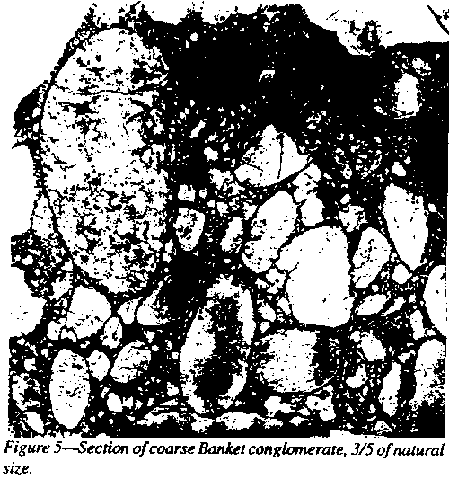
1 Blanket was a local term, now widely adopted, for this gold-rich, brown, oxidized conglomerate, because of its resemblance to almond rock.
The narrow time-slot of the Blanket has already yielded from a small region of South Africa more than half the world's gold since the beginning of civilization.. It is difficult to understand why such a vast tonnage of gold has been produced from a few thin conglomerate beds. Sharp argument has raged for a century between placer and metasomatic advocates. Rand geologists, who believe they know the reality, mainly believe the placer model. Visiting specialists mainly advocate later epigenetic fluids.
Each side has marshalled facts convincing to them, but agreement is no closer now than it was 50 years ago. Each camp argues in terms of present processes of erosion, sedimentation, chemistry, and metallo-genesis. "The present is the key to the past" is the ruling creed.
The problem is to distinguish processes at the time of the blanket sedimentation from events that may have occurred during the eons of subsequent time. Certainly there were later cross-cutting veins and stringers carrying minor sulfides such as pyrhotite, sphalerite, arsenopyrite and galena (normally absent from the reefs) and gold, but their gold values are greatest next to though less than within the reefs, implying that they derived their gold from the reefs.
Could it be
that, like the BIF, the special environment of this time-slot was crucial?
Wind erosion transport and deposition could be significant, but apply equally
throughout the Proterozoic and early Paleozoic. But not the lack of free
oxygen.
 |
The ultimate source of the associated sediments must have been siliceous granitic terrain to the northwest--extensive areas of it. Wind deflation could reduce the landscape, leaving behind the high density gold to enrich the surface. Streams - at least sometimes - were vigorous because they transported pebbles, very well rounded, hence very long distances (Figure 5). Such streams would transport dense minerals such as osmiridium, uraninite, rutile, ilmenite, chromite, cobaltite, pentlandite, diamonds, and any others present, and should also transport gold, even of nugget size, if the gold survived transport.
But without free oxygen in the atmosphere, the solubility of gold in water would have been significantly increased. Yes, after long transport from a wide source region, the gold would perennially reach the site of sedimentation, not as free particles, but in solution, from which it might be precipitated by organic matter or iron minerals, which only occurred in the few favorable beds. The placer and diagenetic disputants could have been both right! The gold was transported thither by surface streams (in solution), and the gold was deposited in the blanket (from solution).
A problem for the metasomatism advocates has been the source, in this narrow time slot, of very large volumes of gold-enriched solutions.
This sedimentary basin was steadily sinking 10 km relative to neighbouring regions, so the underlying mantle must have been colder and hence denser, without temperature changes to less dense minerals - eclogite to gabbro, stishovite to coesite to quartz, spinel and garnet to feldspar, and so on. Partial melting came later. But the gold-enriched solution was already there, waiting passively for appropriate detrital minerals to precipitate the gold. None were in the prevailing quartz sands. They came with the blanket pebbles, and less frequently with the wind-borne pyritic sands in the East Rand - in places very rich in gold, as much as an-ounce to the ton.
The reefs, four or five of them, usually less than 3 m thick, persistent over wide areas, graded (with biggest pebbles at the bottom, smallest at the top) with well rounded pebbles of vein quartz - glassy white, mottled grey, and black, opalescent blue - also some pebbles of quartzite, banded chert and jasper (some flatish bun-shaped), quartz porphyry, and rocks from thermal metamorphic aureoles. Largest pebbles may be up to 20 cm but usually less than 5 cm. The perfection of pebble rounding is inconsistent with a single flood, but indicates a long period of travel and intermediate deposition.
The matrix ranges from microscopic particles to "buckshot pyrite", rarely with tiny crystal faces, but more commonly showing abrasion. But some of the "pyrite pebbles" are replacements (the metasomatists believe they all are). Other sulfides occur, more commonly near mafic intrusions. Pyrite and carbon, and perhaps bacteria, precipitated the gold.
Pyrite occurs as veinlets and partial replacement of pebbles, so pyrite is certainly not all detrital. In the oxygen-free atmosphere, magnetite may have been the detrital mineral to be reduced by algae and converted to pyrite by H2S. Magnetite, hematite, and ilmenite, which are normally abundant among detrital heavy minerals, are conspicuously missing from the blanket.
The gold is always accompanied 9:1 by silver, the proportion varying between stopes. Carbon (thucolite) is a universal companion of the gold. Throughout, gold is richest in "pay-streaks" of coarser blanket, clearly "current channels", continuous through several mines.
The Witwatersrand gold fields would thus owe their unique richness to the fact that oxygen-free streams, after dissolving gold from quartz veins and impregnations of the Barbeton beds and other extensive contemporary auriferous formations, flowed into a lake basin subject to evaporative water reduction, retaining the gold and increasing its concentration, whereas similar streams elsewhere were diluted in larger bodies of water.
The 10-km subsidence of the center of the basin with tilting up of the rim meant that by the time of the gold reefs the basin had been considerably restricted. Continued subsidence eventually produced partial melting of the basin floor producing the Ventersdorp lavas (a few gold-bearing placers here were derived from erosion of the blankets), followed by the thick dolomite of the Transvaal System. Further melting of the deeply depressed floor yielded the great Vredefort granitic diapir in the center of the basin, surrounded by its ring of steeply dipping sediment. Cover by the Karoo System and subsequent erosion has exposed the Witwatersrand Basin rim, now divided into twin basins by the 80-km Vredefort Dome.
Assuming this model to be valid, what are the chances of finding another Rand?
Second, to a limited basin, subject to evaporation, in which the gold could accumulate in solution to much higher titre than normal.
Third, precipitating minerals must be confined to very limited horizons, for otherwise gold would be diluted uneconomically through a thick sedimentary column.
If we set aside theories of divine creation, or the assumption that life spores are universal through infinite time so that any suitable environment in the Universe would eventually be seeded, the progression of life on Earth is an obvious one-way trend, from primitive prokaryotes of bacteria and viruses of 3 eons ago, through stages to eukaryote nuclei in multicelled organisms, to fish, to dinosaurs, to man.
But how did it start? Whence, in the primitive oxygen-free CO2 nitrogen atmosphere, come the enzymes necessary to produce proteins? It has been suggested that volcanic H2S could reduce iron to release electron energy to begin the fixation of nitrogen. This is not necessary as solar radiation would have been sufficient energy source.
Wald has pointed out that an atmosphere was necessary to shield energetic solar rays, which would have destroyed macromolecules, but thin enough to allow energizing radiation, but without free oxygen, which would have oxidized likely precursor compounds, and a temperature to allow liquid water. Such conditions are reasonable postulates on the early Earth and could allow the spontaneous formation of likely pre-biological complexes such as poly-saccharides, polypeptides, proteins, polynucleotides and even nucleic acids, which might, with suitable catalysts, condense and dehydrate to bacteria, which might self propagate.
All terrestrial life shows the same kind of genetic code, the same twenty protein-building amino acids, the same energy-transferring molecules, all of which suggests a single event, a single ancestor for all life on Earth. As this has only happened once in four billion years, it must have been a very improbable event. Alternatively, a suitable environment (for example total absence of free oxygen) may have only been available for limited time.
Experiments with analogues of primitive "soups" reasonably expected to have been present, have produced adenine triphosphate (ATP), the energy source of life, and several other suggestive compounds. Under reducing conditions, amino acids form early but oxidation destroys them. Under plausible pre-biotic conditions in the absence of oxygen, essential constituents of proteins, ribosomes, and nucleic acids could have been present on the early Earth. The first crucial crisis developed when the oxygen life itself produced threatened to exterminate it. Accumulating evidence suggests that RNA preceded DNA in the most primitive self replicating compounds-an RNA world (Oigel, 1994).
But there are still bridges to be crossed. Alice's mirror on the wall still taunts the experimenters. Template copying has only succeeded with right-handed nucleotides, whereas Nature seems to be a left-handed world! Dextro-rotary amino acids can be found in some bacterial cell walls and in some naturally occurring antibiotics, but such exceptions to the left-handed world are rare.
Sexual regeneration dates from the beginning. If an organism, which possessed gene n but lacked gene m fused with an organism which lacked n but had m, the progeny could have both m and n, to great advantage in the environment.
Symbiosis began early when primitive cells profited by mutual cohabitation, the functions of one complementing the functions of the other, such as in lichens and stromatolites. When some prokaryotes began to ingest other prokaryotes, a crucial step occurred about 1.4 billion years ago, when victim tolerated the ingester and even profited by using its waste. So began intra-cell symbiosis, and the first eukaryote. Thus, the mitochondria, plastids, and chloroplasts of living cells originated as symbiont-ingested bacteria.
Eukaryotes have ten thousand times the volume of prokaryote bacteria and phagocytically ingest them as food in a fold of the cell membrane which might pinch off to become an internal lysosome. Less commonly an ingested bacterium might survive in the cytoplasm with its own primitive DNA, and become a plastid, mitochondrian or peroxisome.
The specific origin of the cell wall and cell nucleus are crucial steps still to be found.
Early stromatolites, structures of various minerals, but principally carbonates, held together by bacteria or cyanophytes (later, sometimes eukaryotic chlorophytes), are found in all continents from 3 to even 3.6 billion years ago. Shielding in such stromatolite colonies may have been vital to the survival of primitive eukaryotes during the oxygen crisis.
But this does not imply a marine connection - the "phantom global sea" of Preston Cloud. M.R. Walter, a leading authority on stromatolites, has reported that the cyanophytes that form stromatolites can survive total desiccation for decades and recommence multiplication immediately on wetting. An 80-years-old thin section of a stromatolite for microscopic examination revived in water and began to regrow.
Hence from a drying basin, spores could be blown many times around the Earth, and still start new colonies wherever the environment was favorable. Identical species could appear in a basin on the other side of the Earth without any interconnecting ocean; They could be ideal for time correlation, if a valid taxonomy can be established.
Sir Edgeworth David, after establishing the presence of radiolaria in lower Paleozoic rocks devoted the last years of his life (to 1934) to what he believed to be arthropod fossils in Proterozoic strata from Teatree Gully of South Australia. He made many trips to the field, and laboriously napped several tons of quarried rock transported to his Sydney home. Tillyard, leading contemporary arthropod paleontologist, was convinced that the selected specimens were indeed arthropod fossils (David and Tillyard, 1936). But sceptical geologists and biologists denied them.
I myself looked at the prime specimens as my former classmate Dorothy York prepared drawings for publication, but I lacked the expertise to hold an opinion on the controversy. The argument died with David. It was sacrilege to impugn the aura of the great man. So to this day the matter is never mentioned. Could David have been right? This was an enormous step beyond contemporary wisdom and creed. Pythagoras, Copernicus, Harvey, Darwin, right as they were, were all disbelieved. Perhaps now, after 60 years, it is time to review the case. I think not.
Ediacaran fossils, later discovered by Sprigg also in the Flinders Ranges of South Australia, in rocks quite substantially later than David's source, and now known from this epoch throughout the world, ended the debate.
The Ediacaran fauna may have been wind-borne as encysted spores. G.J. Retallack (1994) has suggested that the Ediacaran fossils are probably remains of lichens--cohabiting photosynthetic algae and fungi - which could form tougher colonies more resistant to fossilization than jellyfish consisting of 99% water.
Retallack's suggestion looks good for some of the Ediacaran fossils, but some were certainly not jellyfish. A variety of impressions up to several cm in diameter have been interpreted as metazoan Porifera. Spriggina and Dickinsonia, which are beautifully preserved, had bilateral symmetry, were non-symmetrical longitudinally, or front and back. They could be the ancestors of a trilobite, or of several of the Burgess Shale arthropods.
Perhaps the Ediacaran contains an endemic association as well as a wind-borne group. In the lists that I have seen only the the so-called coelenterates are widespread, whereas those classified as annelids or arthropods are only recorded from Ediacara and the White Sea area of Russia, which could have been in the same lake at that time (Figure 40 and p. 61). The Burgess Shale fauna, Cambrian archeocyathids, and the Olenellus and Redlichia trilobites were not transported by wind. The Cambrian seems to be a watershed, perhaps because the waxing oxygen content of the atmosphere halted free-loading on the wind. These differentiated Cambrian faunas, presumably all descended from common Eo-cambrian ancestors, that in turn had descended from a common ancestor some 3 billion years previously.
Each period had its characteristic index genera: Stromatolites recorded by Hoffmann and Masson (1994) from 2.7 Gya. Abitibi Greenstones of Quebec, the Eo-cambrian Ediacaran suite, Early Cambrian archeocyathids, later Cambrian trilobites, Ordovician graptolites, Silurian corals and sea scorpions, Devonian brachiopods, Carboniferous forests with reptiles and insects, Mesozoic dinosaurs, and Tertiary flowering plants, to name only some. Paleozoic corals precipitated CaCO3 as calcite, whereas Mesozoic corals precipitated it as aragonite.
Stratigraphy was born with recognition of faunal succession. Baron Cuvier, greatest paleontologist of his time, believed each assembly to be a specific creation following the catastrophic destruction of the preceding assembly, as God, master creator, advanced his models-like the "evolutionary" succession of Fords, from model T to the latest dream car.
Cuvier's contemporary, Lamarck, thought that environment modified the race, but Darwin argued that the environment merely selected from small random variations, those which succeeded in the pre-vailing environment. In contrast, Hoyle and his co-authors argue that organisms did not begin in Archean ponds, but that the Earth is continually seeded with organic molecules from cosmic dust, possibly as complex as viruses. The single descent net of terrestrial life argues against this; random seeding by cosmic rain would surely involve random genealogies.
A crucial step was the migration to the land from shallow sea or lakes. Primitive plants were first. Animals experienced weight for the first time. Their skins dried. Daily temperature extremes replaced almost constant water temperature. Waste heat from metabolism and muscular activity had to be dissipated. Oxygen was now taken from the atmosphere via water-lined lungs instead of from aqueous solution. From fertilized ovum to human adult, oxygen is sequestered from body fluids, whose macromolecules it would destroy. This has been true throughout evolution from eukaryotes.
The evolutionary vertebrate line is thought to be fish to amphibians to tetrapods. This may be correct, but the Silurian vertebrates seem to have been preceded by Ordovician centipede-like arthropods.
The fossil record contains "bursts" of evolution. After nearly 3 billion years of painfully slow evolution of the most primitive prokaryote life, an early Cambrian parent led to archaeocyathid algae, small-shelled animals, arthropods, and acritarchs, thence to all modern phyla within only 5 million years. No new phylum has appeared since - only diversification of Cambrian phyla. (The Bryozoa are not known before the Ordovician but this could be an artefact of failure to find them).
The Cambrian Period has traditionally been estimated to have lasted at least 50 million years. But this has recently been curtailed to no more than 20 million years, although debate is still hot on the precise correlation of east Siberian and Avalon (Newfoundland) sections. The Cambrian burst of evolution was indeed an explosion!
At the end of the Permian a primitive thecodont reptile sired eight new orders (pterosaurs, ornithischians, saurischians, sauropods, crocodilians, birds, snakes, and lizards) that remained separate thereafter. All known flowering plant families suddenly appeared in the Cretaceous.
Nevertheless, most biologists believe that life only evolved by minuscule mutations of minor changes in individual genes, that "missing links" are only fortuitous gaps in the fossil record, which a lucky find could fill. As Darwin said, Natura saltum non facit (Nature does not jump).
Creationists make much of the crucial gaps in the continuity of the fossil record. They emphasize the missing link between prokaryotes and eukaryotes, primitive and modern plants, between single cells and invertebrates, invertebrates and fish, fish and amphibians, amphibians and reptiles, reptiles and birds, reptiles and mammals, land mammals and sea mammals, terrestrial mammals and bats, and of course, apes and hominids. Even granting the incompleteness of the fossil record, why does it fail at significant jumps?
Far from a problem, such explosive bursts with giant steps should be anticipated. A definite, very small fraction, of the carbon incorporated in food is radioactive carbon, 14C, which is continually produced by solar radiation of atmospheric nitrogen, and ultimately incorporated into living cells.
A miniscule but real fraction of the carbon in genes must therefore be radioactive carbon, the spontaneous reversion of which to nitrogen, stable 14N, must alter that gene, usually lethally, but rarely, exceedingly rarely, yielding a new and different viable gene, as a spontaneous mutation.
The effect of most such mutations would be trivial, but very rarely, depending on which particular carbon atom, in which gene, was changed to nitrogen, the effect could be crucial, triggering a burst of evolution by making viable many of the more frequent mutations, which could not have been effective without that ultra rare key. This may not be the only mechanism for a significant but extremely improbable mutation.
Nature does jump - rarely, very rarely indeed, but sometimes! Of course, even a potentially successful jump, and certainly a lesser leap, could fail if the environment, be it climate, predators, or competition for food, stifles its start. The awe and wonder of creationists, that the natural environment is so perfectly adjusted to the crucial needs of new life, could not be otherwise. Potential new life, which pops up continually in every conceivable form, can only survive where the environment happens to fit it perfectly.
Related to bursts of evolution are mass extinctions. The sharpness of the extinctions has been over emphasized, especially when applied to several families. The extinctions at the end of the Ordovician, Devonian, Permian, and Triassic could be steps in the 50o shift of the equator from its Caledonian-Appalachian position to its Tethyan position. The Cretaceous-Tertiary extinction could be caused by the 50o shift of the equator from its Tethyan position to its present position. Certainly these shifts must have produced vast global environment changes with many extinctions, followed by bursts of opportunist evolution. The axial shifts were spread over substantial time, but they may have been in impulsive steps rather than smooth.
The chance development of the first self-replicating compound in the late Archean began the ladder of evolution. Of the thousands of variant replications that followed, most failed in the contemporary environment, a lethal filtration which has been repeated millions of times. Could such a chance compound have appeared on Venus, or Mars? Yes, but the odds against are astronomic, almost infinite. But so is time! And the odds against such a Venusian self-replicating compound bearing the slightest resemblance to ours is even more astronomic.
Any that did survive the pervasive environment would not resemble earthly life, because the environments are so different. Eons later, a Venusian or Martian "biologist" could marvel at the nearly impossible precision to which their environment had been planned to fit so exactly the needs of life forms, so that only a divine creator could have planned it!
Some have suggested silicon and ammonia instead of carbon and water as source for a biogenic replicating system. While very improbable on Earth, such could be the viable route in a very different environment somewhere in the Universe.
The elucidation by Crick and Watson of the male-female double helix of chromosomes made a quantum leap to the biochemistry of heredity. Soon, genes coding for specific proteins were identified in a permutative language of four amino-acids as geneticists raced ahead to a translation of the genome, only to be frustrated, as it emerged that only 3% of the DNA coded for proteins. Many thought that the remaining 97% was gibberish, just junk DNA - meaningless dilution. I do not think so.
The proteins are like the heaps of bricks, tiles, water pipes, and sanitary ceramics on a new building site. An architect and many skilled tradesmen convert it into a mansion. Passions, emotions, and mind make it into a home. The 97% junk DNA does have vague signs of order. Genes have poorly-understood adjectival introns (10% of the whole) which qualify them; long sequences of "alus", another 10%, jump about the genome, have yet to find a meaning, and another recurrent sequence type called "line-A", make up make another 5%. We need a new "rosetta stone" to enter a new world of understanding - and it will come where we least expect it.
Life on Earth now gathers speed to a unique climax. Homo sapiens is about to saturate the planet to exhaustion - water, food, energy, waste, lebensraum.
Pleistocene glaciation is mainly studied in continental landforms, Permo-Carboniferous glaciation in geosynclinal sediments with some striated pavements, and more ancient glaciations mainly in geosynclinal remnants; but this is only a matter of degree of preservation.
Glaciation is the main evidence of past cold climate, but of course small glaciers can occur anywhere if the altitude is high enough, so continental glaciation at sea level is necessary. Luxuriant forests may occur in maritime regions if rainfall is high.
Glaciation involves change in seal evel. Withdrawal of water from the oceans to lock it up in continental ice, causes sea-level to drop globally. Isostatic depression by the load of ice, causes rise of sea level only for the loaded region.
Polar glaciations may also be implied in tropical regions. Variations in the terrestrial dust content in Atlantic bore cores off West Africa correlate closely with advances and retreats of high latitude ice sheets. The mid-Pliocene advance of glaciation is closely recorded in the tropical marine bore cores and correlate with changes from rain forest to savannah and even desert (de Menocal, l995). The cyclothems of the American Pennsylvanian--cycles through non-marine sandstone, non-marine limestone, non- marine shale, underclay, coal, marine shale, marine limestone, brackish-water shale, then this cycle repeated again and again-is interpreted as the tropical equivalent of polar glacial cycles.
Most of the characters of tillite can be found in non-glacial diamictites - rarely even striations may be found in marine slumps - but glaciated pavements are final evidence.
The present world climate cannot be assumed to be the "normal". Major glaciations are not uniformly distributed through geologic time: The oldest claimed glaciation- (recorded at the base of the Animikie Supergroup) the Gowganda Formation of the Huronian Supergroup in Finland and adjacent Russia, the Baikal region of east Asia, central India, the Hammersley region of Western Australia, and equivalent formations of South Africa) - occurred some 2.3 billion years ago (before the global banded iron formation). This ancient glaciation does not differ significantly from the most recent glaciation commencing 2.8 million years ago, being global, with striated pavements, striated pebbles, dropped pebbles and boulders, and varvites.
The Late Proterozoic glaciation was the most prolonged and widespread of all, extending from at least 1000 million years ago to 600 my. The type sequence is in the Flinders Ranges of South Australia, but all continental shields except Mongolia, India, and Antarctica record it. However, the wide time span probably includes at least two glaciations.
Most paleomagnetic datings of associated rocks indicate low latitudes. Some argue that the paleo-magnetism has been reset, and that the glacial sediments themselves are a more reliable indicator of latitude; others that the continental shields were mobile, and were glaciated when they occupied polar regions (the correlations are somewhat vague); others invoke high obliquity because when the obliquity reaches 40o, equatorial regions are glaciated rather than the poles.
Upper Ordovician glaciation has been proven in the central Sahara, and a coeval Pakhuis Tillite occurs on Table Mountain of South Africa, the Caledonian- Appalachian-Tasmanide orogen being then equatorial. All Gondwana continents record extensive glaciation epochs through the Late Carboniferous and Early Permian - southern and central Africa, Arabia, Australia and Tasmania, peninsular India, southern South America, Falkland Islands, and Antarctica - with tillites, striated boulders, striated pavements, varvites, and dropped-pebble marine strata. They extend north into China, but only sporadically on Laurasia, and most of these records have been reinterpreted as non-glacial (e.g. the Kancherovskije breccias in the southern Urals). The Sakmarian Kygyltas suite in the Verkhoyansk Range, which is antipodal to the Gondwana glaciation (Figure 6), does contain boulders with glacial striations.
Gondwana glaciation
started in Late Carboniferous. David first recorded Rhacopteris flora in
tillite interbeds, and several thick tillites rest on peneplaned striated
pavements and are overlain by Early Permian marine fossils. An indefinite
time elapsed from the beginning of glaciation to these fossils. Glaciation
is repeated in many places. David reported 11 distinct tillites in a Victorian
section and Du Toit recorded five separate tillite horizons near Laingsburg
in South Africa, and numerous tillite pulses are a common phenomenon. In
Tasmania glacial episodes continued intermittently much later in the Ferntree
Mudstone, regarded as Kazanian; it contains marine dropstone horizons but
no tillite or varvite.
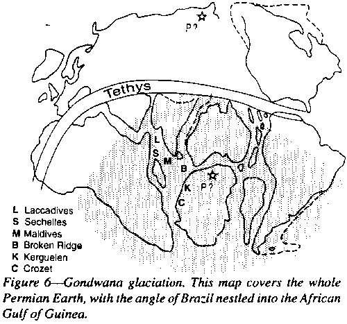 |
On reconstructed Pangea the Gondwana glaciation forms a tight cluster (Figure 6) and when it is remembered that this diagram of the whole globe has been flattened out and that the angle of Brazil wraps back into the Guinea Gulf of Africa, the Gondwana glaciation was circumpolar with the pole somewhere in Antarctica. Note that in several places striated pavements indicate that the glaciers flowed on to continents from what is now deep ocean: westward flow from the Indian Ocean on to Natal, northward flow from the Southern Ocean on to Australia, from the Atlantic Ocean on to Brazil, and on to southern Arabia from the Red Sea.
The marked asymmetry between Gondwana and Laurasian glaciations is one of the reasons for suggesting hemispheric alternation of glaciations, but such proposals are still speculative. An axial tilt with a girdle of Permian red beds through Europe to Texas is a more likely explanation.
However, the reconstruction of the Permo-carboniferous glaciation of Gondwanaland as suggested in Figure 6 involves apparently fatal problems. The stark asymmetry of the two hemi-spheres defies explanation. Even more intractable is the suggested glaciation of so large a continent. Glaciers have to be fed by continuous snowfall, but the interior of such a continent could be frigid-but arid. Introduction of extensive epeiric seas would freeze to their floors, and thereafter, no more moisture.
Was Earth temporarily tilted with the north pole facing the Sun? Uranus is now like this, why not Earth? But the glacial sediments are interbedded with fossil Rhacopteris leaves Dadoxylon wood with perfectly preserved growth rings.
Some northern hemisphere geologists doubted the validity of the great glaciations, and sought other explanations of the data, such as gross slumps which could account for the diamictite, and even the striated pebbles and pavements. But close study of glaciated pavements reveals other features - crescentric gouges, sickle-shaped grooves, etc. which are not replicated by landslides. Overbeek, Marshall, and Aggarwal (1993) and Rampino (1994) suggested that the diamictites were the product of large asteroidal impacts. Multiple impacts to the same region would be needed to explain the successive glacial horizons interlarded with other formations.
The Figure 6 reconstruction covers some 80 million years, so smaller more local centers of glaciation might move around, say earlier in Brazil, and latest in Tasmania, where large erratic blocks were dropped into marine late Permian Ferntree Mudstone.
The Gondwana glaciation remains enigmatic.
Glaciation could perhaps be cyclic, related to Earth's orbital cycles, variation of Sun's radiation, or a galactic cycle of some 300 million years-the Permo-Carboniferous glaciation about that interval before the Quaternary glaciation, the Late Proterozoic glaciation some 300 million years before that (the glaciation in the Ordovician does not fit) and still earlier glaciations. Williams (1975) has suggested an astronomic glacial cycle of about 155 million years, but this fails in the Jurassic. Periodicity of global glaciations has not been rigorously established.
For the cause of the glacial periods as opposed to glacial ages, a solar "galactic year", has been suggested. Variation in albedo through cloud cover, has been invoked. A 201% departure from the present mean could indeed account for Tertiary warm periods and Quaternary cold periods, but no explanation has been offered for such variation. Opik argues that the Sun's luminosity varies by as much as 20%.
Milankovitch argued that ice ages within a glacial period may be governed by astronomic cycles such as perturbations of the orbit, but Opik (1952) considered this insignificant. Others suggest causes within Earth, such as polar wandering, continental drift, times of high relief, the relative proportion of land and sea, magmatic cycles of volcanism filling the atmosphere with dust, variation of stratospheric ozone or CO2, changes to the ocean-atmosphere heat exchange, or to the ocean current circulation. Each of these is rejected by other critics. The problem is still unsolved.
The current glaciation began with a sharp temperature drop at the beginning of the Oligocene, followed by 20 million years of oscillation but overall warming, then another sharp drop in the middle Miocene. During the early Pliocene global climate was dominated by the precessional cycle, but a sharp fall in temperature occurred 2.8 million years ago (de Menocal, 1995). The present interglacial started about 10,000 years ago, and may suddenly revert to glaciation, but there is no obvious imminent threat of that (nor certainty that it could not suddenly happen). Renewed refrigeration would not necessarily mean a more extensive Antarctic ice sheet, because there may be an inverse relation with precipitation.
An ice-free globe would involve major disaster for present civilization. The melting of the polar icecaps would involve a sea-level rise of 50-100 m, which would drown not only many oceanic islands, but most of the densely populated regions of the world. London, Paris, Berlin, New York, Calcutta, Bombay, Tokyo, Hong Kong, Singapore, in fact most of the great cities of the world would become lairs for lobsters.
The reverse situation of a new ice age would be nearly as disastrous. Scandinavia, Canada, Germany, and Russia, and vast agricultural lands would be deeply buried under ice. Either scenario could happen relatively rapidly-hundreds, not thousands of years!
Antithetic to glaciations are the epochs of red beds. They depend on an oxygen-rich atmosphere, so would not be expected before the Late Proterozoic. Red beds were indeed abundant in the Late Proterozoic in many regions of the world. The early Devonian (Old Red Sandstone), and the Late Permian-Triassic New Red Sandstone, (evaporites, and chocolate shales are globally prominent) seem to have been arid times. Do we have here suggestion of a solar variation with glaciation and aridity at the extremes?
Granite is one of the commonest of rocks. Yet literature of granite genesis, which began with the earliest contemplation of rocks, has continued through many theories to this day. At each stage the ruling doctrine was thought to have settled the matter.
The "granite problem" began with A.G. Werner (1749-1817) of Saxony, who taught that all granite, the oldest of all rocks, was the primitive precipitate from a global ocean. James Hutton (1726-1796), of Edinburgh, demonstrated that his granite was the irregular floor of sedimentary strata, and terminated upward in irregular transgressive contacts, with tongues and dikes of the granite invading fractures in the overlying strata, and that these showed sign of having been cooked by the intruding granite.
So granite became accepted as an invading molten magma which had come up from the depths and crystallized. Potash feldspar, often present as phenocrysts, was one of granite's distinguishing characters.
The "room problem" followed. Many granitic batholiths of vast dimensions, seemed to simply cut across the strata. Remnants of the country rocks cropped out in their roofs. Where were the rocks, which were replaced by the granite beyond the contacts?
The room problem, which remains serious for magmatists, is really due to the universal meme that orogenesis is a compressional phenomenon; it does not arise in an expanding Earth scenario. Some committed compression geologists seek to escape the room problem by postulating slightly oblique transcurrent tectonics which may result in substantial tensional openings to be filled by magma. Such escape is quantitatively inadequate.
Stoping on a grand scale has 'been invoked, whereby huge blocks of roof rocks sank through the magma. But mafic dikes in such belts remained identifiable until difference from the host which they had intruded had faded. That these denser mafic rocks had not sunk, weakened the stoping concept. Stoping does not create space, nor does assimilation of the country rocks.
More recently, some geologists have avoided the room problem by claiming that batholiths do not persist in depth, but are mainly relatively thin sheets with much greater area than thickness, so that room is made by upward expansion. However, gravity surveys over granite batholiths, indicate that generally they do persist in depth.
Commonly a long outcrop of metamorphosed country rock, in structural continuity with the surrounding region, extends far into the granite, gradually losing its identity, but still traceable as a "ghost" in the granite. In places a band of limestone , first recrystallized, then silicified or silicated, extends meters into the granite.
Such structures should have been disrupted if the granite was an intrusive molten magma. Apparent "ghost stratification" on a large scale has been claimed in granites, implying gross transformation of sedimentary strata into granite.
Hence there was a rising belief that the granite had not just pushed the strata aside, but had absorbed them, melting them and incorporating them into the granitic magma. Geikie in his 1884 presidential address to the Geological Society of London, observed that "Granitization had again reared its head".
Granitizers found sedimentary relics in all stages of incorporation-little-altered metamorphosed relics, easily recognized as little different from the contact rocks, through to ghostly relics, feldspathized and little different from the absorbing granite. In metamorphic terrains, all stages could be seen from clearly sedimentary rocks metamorphosed to schist and gneiss, to migmatites with both sedimentary and granitic layers, to normal-looking granite.
The concept that an intruding molten granite magma had melted and absorbed the sediment, was replaced by the concept that geosynclinal sediments had simply been transformed into granite with little addition of abyssal fluids. Granitization dominated more and more.
"Dry" metamorphism, graded into "wet" granitization with varying contribution from abyssal fluid, either aqueous or in the gas phase (above the critical temperature). Granitization reached its peak in Read's presidential addresses to the Geological Society of London (1948, 1950). The "granite problem" was now solved. Field geologists and granitization became dominant.
N.L. Bowen (1928) led laboratory teams along a different path. Molten basalt allowed to cool slowly, first crystallized mafic minerals, such as olivine and pyroxenes, settled out, leaving a magma increasingly enriched in silica, alkalis, and water, so that a residual granitic liquid would result. They pointed out cases where early plutons were gabbroic, then pyroxene-mica-diorites, which were followed by tonalites and true granites. But no granites have been found in oceanic areas, although basalt is abundant.
S.R. Nockolds (1940), made a convincing case for Bowen-type fractional crystallization as the main cause of differentiation of magma to magma suites similar to those seen in lavas. Certainly, some granitic plutons, such as several bodies in the Scottish highlands, were differentiated by fractional crystallization.
Others applied this principle, not to basalt, but to siliceous melts coming from the roots of a geosyncline, because the relative proportion of felsic to mafic differentiates in batholiths did not quantitatively match a basaltic origin. Mesh filtration and assimilation were added to achieve better fit. Magmatic differentiation with chemical variation diagrams became the ruling fashion, and chemical petrologists dominated.
W R. Browne, saturated by years of study of the Cooma "gneiss" of eastern Australia, pioneered the role of orogenesis; recognized "synchronous" and "subsequent" granites. The former, being in the axial belts of folded zones, conformed in outlines, cleavage, and schistosity with the axial sediments, with lit-par-lit relation and migmatite stringers which could be either magma or partly digested sediment. Granite and intruded sediment were essentially at the same temperature and fluid saturation. Subsequent batholiths were injected at higher levels, had sharp boundaries between hot granite and cooler intruded sediment which showed only contact metamorphism. This distinction was later developed by many writers as S-and I-type granites.
Pneumatolitic fluids form tin, tungsten, and molybdenum veins around the crest of rising plutons, while the granite itself is enriched in boron, fluorine, and rare earth elements, so that the granite contains tourmaline, topaz and monazite. Other ore atoms, also in concentrations too low to crystallize from the magma, remain in the residual fluid, which eventually splits into two liquids, becoming more immiscible as temperature and pressure drops-one a siliceous liquid saturated with water, and the other an aqueous liquid, saturated with silica and siderophile atoms. The former has high viscosity, does not travel far, and forms pegmatites, whereas the latter, with much lower viscosity travels further and forms hydro-thermal sulfide veins, with copper, zinc, lead, arsenic, and silver.
Field geologists were now prominent, and some emphasized the associated joint patterns within and around the granite as indicators of movement. But the commonest joint pattern throughout batholiths and regional metamorphic rocks is "epeirogenic" jointing - that is two nearly vertical sets mutually nearly normal, which indicate regional extension (Figures 98 and 99).
Next, geochemists made intensive study of isotopes of the major and often of the very minor elements as indicators of deep igneous origin, contamination by melting of sediments, or derivation wholly from sediments. Many granites were found to have the same ratio of 87Sr to 86Sr as mantle rocks, which seemed to imply that the granite magma was derived from mantle melting.
A "red herring" was introduced by the birth of the spurious subduction hypothesis, whereby granites were derived from partial melting of the alleged down-going slab and sediments dragged down with it. Petrologists think of magma entirely as complex melts or solutions, ignoring the role of colloids. But John Elliston has emphasized that a one-meter cube of rock has a surface area of 6 square meters, but that the similar block of wet clayey sediment has a surface area of 60 million square meters, and that the several phenomena of surface chemistry wholly dominate.
If such sediment is made into a stiff cream consistency and beaten in a cake-mixer, clots form like those commonly seen in disturbed geosynclinal sediments, which may be seen to develop into feldspar and quartz phenocrysts, while the rock develops into "porphyroid", called by petrologists quartz-feldspar porphyry (Elliston 1963). The essential shear develops through bedding surface slip during concentric folding (probably more than most realize) and more so with the slatey cleavage when similar folding begins to replace concentric folding (Figures 13 and 18, pp. 42, 44).
Elliston (1984) after years of intensive world-wide study of porphyroids, orbicules, and rapakivi granites, demonstrated how these developed through colloidal processes in the water-saturated, but non-molten state; he believes that granites generally develop in this way. Wherever fully hydrolysed sedimentary materials are sheared by flow, as in the central belts of orogens, silica and feldspars separate from hydrous ferromagnesian minerals. Silica from the residual tetrahedral layers of clays reaggregate as the precursors of feldspars and quartz, and separate physically from the more mobile water-rich ferromagnesian hydrates and hydroxides, which form basic dikes and "basic fronts".
Elliston maintains that rapakivi granites and orbicular structures generally are quite impossible to derive from granite melts. Exothermic crystallization generates adequate heat for the observed ~600oC thermal metamorphism. Colloidal processes are the key to granite genesis. Physical chemists trained in surface chemistry of colloids find such processes normal and expected, but few petrologists delve beyond the phenomena of solution and melts. The next major contribution to the granite problem may be expected from this field.
But some granites and granophyres seem equally positively to be Bowen-type residual granite melts, such as Nockolds' Scottish plutons and the red granite of the Bushveldt lopolith. Are there then granites and granites?
My eclectic choice is to recognize two categories of granite genesis. The rapakivi-type granites and major granite batholiths in the axial zones of orogens are generated through solid-state colloidal metamorphism of sediments, including synchronous and subsequent S-and I-type granites. There may be some additional mantle-derived melt.
I also recognize major magma-melts from the mantle, including flood basalt, the vast volumes of new basaltic crust generated at the mid-ocean ridges, the large Jurassic diabase basalt and similar older occurrences, the great anorthosite which was so abundant about 1.5 billion years ago, the generally smaller plutons which have been intruded as liquids and cooled in a non-shear environment by crystal-settling differentiation, and the dike swarms through the ages.
Ophiolite (literally "snake-rock" : serpent-stone) is a suite of rocks derived directly from the mantle, which occurs in orogenic zones of various ages, but most studied in the Tethyan belt - Troodos, Oman (Semail), Papua, and New Caledonia. A Paleozoic example is the Great Serpentine Belt of New South Wales, studied in detail seventy years ago by W.N. Benson.
(2) Another is at the birth of a eugeosyncline where continental crust has been thinned to zero and still extending. The associated bathyal sediment is porcellanite and radiolarian chert, below the depth of complete solution of calcareous tests.
(3) A third category is along gross megashears accompanied by some transverse extension, where slices of mantle are dragged to the surface in a sheared melange a considerable horizontal distance from their source.
Typically, the Troodos-Oman-Papuan ophiolite category develops in a belt of rapidly stretching oceanic lithosphere. It consists of a thick lower mass of peridotite, then a zone of cumulate built up by the sinking of olivine and pyroxene crystals, then a zone of sheeted basaltic dikes where gabbroic magma splits in tension as it congeals, the opening being immediately filled with more magma, which then rifts again, and this process may continue until the zone consists almost entirely of near-vertical sheeted dikes. Magma continues to burst through the sheeted-dike zone to extrude as spilitic pillow lava. The whole complex is then intruded by late differentiate as small plutons such as trondhjemite. We must visualize a substantial volume of molten mantle in a zone of sea floor which is rapidly stretching, the magma chamber self sealing as the magma extrudes.
When the continued extrusion of mantle magma reaches its isostatic maximum and molten magma continues to be driven up, the ophiolite body has to spread laterally as nappe overthrust across the basal radiolarian cherts, contorting them and mixing them into melange, while the already solidified basal peridotite, under the heavy load of several km of ophiolite may be forced to flow, tectonized, even mylonitized by the lateral thrust.
The standard model has ophiolite as blocks of oceanic floor thrust over pelagic radiolarite of a new eugeosyncline. In contrast, I propose that ophiolite is not a block of ocean floor, but the sealing tissue which fills the rapidly widening rifts when ocean floor is stretching very rapidly.
It begins in a region of rapid crustal stretching where continental crust is stretched to zero and the deep ocean floor is receiving thin ribbon cherts deep below the level of carbonate solution. Isostacy demands that the widening wound is filled with diapiric mantle matter which continues to drive upward and spread laterally as the rift zone widens. The mantle matter crystallises as ultramafics with later differentiates continuing to rise as gabbros, repeatedly split as it solidifies by sheeted dikes, followed by pillow lavas and later differentiates.
Such ophiolites are not uniformly distributed through geologic time. They only occur at times of rapid extensional rifting of the lithosphere, usually along a great circle. One such epoch was the Middle Devonian. Another marked the beginning of the Tethys.
Let us now look at some of these ophiolites in more detail.
The Semail Ophiolite, which forms an arc of more than 500 km, came at the end of the long period of regional platform sedimentation which lasted from the Late Proterozic general unconformity through the Paleozoic and Triassic until the new epoch of extreme stretching of the lithosphere, which began the Tethyan geosyncline and the disintegration of Pangea.
lt began in deep rifts with Campanian radiolarite ooze (the Hawasina Formation) future porcellanite, and deep-sea variegated chert (the Colored Formation) below the depth of carbonate solution, then pillow lava, then a vast extrusion of mantle magma which solidified at the base and differentiated with crystal settling to ultramafic cumulates of magnesian olivine with some orthopyroxene and chromite. Upward, gabbros extruded and diabase sheeted dikes as the crustal extension continued, then late flows of pillow lava, and final minor intrusions of residual differentiate of quartz diorite, tonalite, and keratophyre. The final magmatic fluids cause extensive serpentinization, zeolitization, and deuteric alteration.
There are some
pyroclastics, because the lower density of molten rock causes the surface
to rise isostatically to sealevel temporarily. Coleman (1981) has reported
a lateritic surface on eroded peridotite below Maastrichtian beds in the
Ira area.
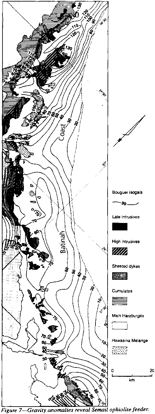 |
The main Oman fault runs along the Oman foothills just behind the Batinah coast (Figure 7), but at the time of extrusion it was continuous with the Zagros line, now just south of Jaz Murian (Figure 40, p.60). The feeder dike-sheet shows up as a line of Bouguer gravity maxima along the present coast south of Dibba, creeping inland to about 50 km nearer Muscat. The isogals decline seaward of the 40-100 mgal central axis at 2 mgal/km and mountain-ward at 10 mgal/km, so there is no possibility of the feeder being anywhere else.
This line was the deepest part of the Hawasina trough, and the line of the pre-ophiolite pillow lavas, the main belt of sheeted dikes, and the rooted post-ophiolite intrusions of gabbro. The final phase, overlying the sheeted-dike series, was late spilitic and keratophyric pillow lava (also some andesite, rhyolite and hyaloclastic matter), totalling up to 2,000 m, and only found within 10 km of the feeder rift. These are partly interbedded, partly overlain, by pelagic sediment with radiolaria, and cut by late intrusives of gabbro and diorite.
The ophiolite was later tilted 10o to 20o by the Miocene folding so the layered cumulates, which may be more than 4,000 m thick have produced pseudo-bedding, which dominates their topographic expression. This cumulate "bedding" was horizontal when the extruded magma solidified. The thick ophiolite and and the underlying Hawasina were stripped off the Jebel Akhdar and Sayh Hatat anticlines.
The ophiolite belt has been disrupted by several transverse faults, which parallel the opening of the Kavir and Oman sphenochasms, and are cognate with the Owen-Ornach-Nal-Chaman-Mogur and the Dibba-Musandam-Hormuz suites. Erosion of these faults break the gross Semail into blocks and form the wadis, e.g. Ham, Hatta, Jizi, and Ahin Wadis, and of course the Semail Gap.
The cumulate zone consists of olivine and two-pyroxene gabbro, and a variety of peridotites. Below the cumulates is the main body of harzburgite. The base clearly transgresses across the Hawasina, as the extruding magma, not being supported laterally, was forced to spread sideways.
The transition boundary from gabbro to sheeted dikes is cupola-shaped, indicating that the transition is an isotherm where the cooling gabbro was solid enough to crack. Near this transition less than 10% of the section is dike, but it increases upward until the dikes make up 100%, which implies total extension during their emplacement. The magma chamber accommodated this extension by flow. This kind of structure can only develop where the oceanic lithosphere is widening rapidly - the most rapid kind of lithospheric widening found anywhere, in this case the rapid opening of the Oman sphenochasm (Figure 40, p.61).
Contact relations confirm a series of sheeted-dike chambers along the feeder rift, a few tens of kilometers long and 5-10 km wide. The sheeted-dikes swarms consist of near-vertical, sub-parallel dikes without intervening host of other rock. As the ascent of magma accelerated, the rift opened more rapidly, admitting mantle melt into widening chambers with harzburgite crystallizing at depth and gabbro above, residual magma forming dikes through the gabbro as rapidly as it solidified, until in the upper levels newly solidified dikes separated by new dikes, so that the sheeted dikes took up nearly all the expansion. The vertical depth of the sheeted dike complex may be as much as 1,500 m.
Late dikes have chilled margins against earlier dikes, and systematic "one-way" chills indicate local direction of spreading (see Rothery, 1983). The sheeted-dike complexes crop out all the way above the feeder channels along the foothills behind the Batinah coast, approximately coinciding with the line of gravity maxima.
The dikes, originally basaltic, vertical, and 1-3 m wide, trending parallel to the Oman rift system, are hydrothermally altered by their late ascending cognate fluids to amphibolite facies near the base (quartz, epidote, actinolite ± chlorite), grading to zeolite facies (albitized plagioclase with variously actinolitized clinopyroxene ± chlorite) near the top.
In some places upper parts of the gabbro have suffered similar amphibolitic hydrothermal alteration. In places, late differentiates from the underlying magma chamber (quartz diorite or trondhjemite) cut a dike swarm, and as these may in turn be cut by a later dike, they are clearly part of the complex.
Some dikes are brecciated, which is not surprising as the continuous widening process was probably staccato. The distribution of cumulates implies that the whole body was still liquid for some time after extrusion. Although the main body was still molten, as indicated by the cumulates, the basal part had been quenched and brecciated forming a peridotite melange, which was bulldozed over the Hawasina melange by the heavy extruding mass above. The distance of travel from the source fissures was never more than 60 km. The spreading was simply gravitational, not tectonic.
The margins of the ophiolite complex are commonly sheared and serpentinized, but generally the main body shows little disturbance, except by the several transverse faults.
In the vicinity of Harim Maydan-Wuqbah block, 50 km southwest of Sahan, the normal vertical sequence from the Hawasina complex, harzburgite, cumulates, sheeted dikes and late intrusives have been mapped, so it appears that the feeder was not a single fracture but rifts en echelon, but the gravity data do not extend far enough to confirm a feeder there.
The Semail ophiolite was a single intrusive diapiric event in very late Campanian, or very early Maastrichtian, because the Hawasina below the cumulate sheet extended well into the Campanian, and the Juweiza Formation, which is probably late Campanian and certainly not later than Early Maastrichtian, contains fragments of harzburgite and dunite with chromite derived from the Semail mass, cherts from the Hawasina, and clasts from the Musandam carbonate. The Juweiza No.1 well penetrates 3,000 m of these sediments which accumulated in a deep basin which seems to have resulted from the loading by the igneous pile.
Nicolas et al. (1988) correctly recognized the diapiric intrusive character of the Semail ophiolite, but were still circumscribed by the obduction meme. The quaint notion, named by Oxburgh "flake tectonics" (Nature, 1972 (239): 202-204), of the Semail ophiolite being the top 10 km of subducting mantle split off midway and "obducted" upward to override the regional rocks, while its other half "subducted" downward below the continent, will become the extreme of absurdity to which blind faith can mislead the human mind, (recall Ptolemy's Earth-centered Universe, Ussher's Earth creation, Kelvin's Earth-age limit, Hall's compressional tectonics).
The Troodos
Ophiolite crops out over some 3,000 km2 as an oval dome 90 km
long and 30 km wide (Figure 8). It was horizontally stratified when formed
in the Campanian and covered by Maastrichtian sediment, but arched up nearly
3 km in the early Tertiary perhaps by extensive serpentinization of peridotite,
and more than 200 km of eastward shift in the Tethyan Torsion (Chapter
4) and some north-south tension during the opening of the Mediterranean.
Subsequent denudation has exposed the complete sequence from bottom harzburgite,
through ultramafic cumulate, gabbro, then sheeted dikes to pillow lava
and late intrusives. The central highest point is Mt Olympus, 1953 m. The
northern flanking 160 km arc of the Kyrenia Range which extends from Cape
Kormakiti to Cape St. Andreas seems to be quite independent of the ultramafic
body. A Bouguer anomaly in excess of 250 milligals indicates the mass of
the ultramafic rock.
 |
The lowest exposed rock type is tectonized harzburgite, which forms 80% of the rock, with sporadic lenses of dunite and irregular pods of gabbro. Greenbaum (1972) interpreted this as depleted plagioclase lherzolite from which gabbroic magma had been melted out The harzburgite consists mostly of xenoblastic folia of olivine (forsterite 90-92) and orthopyroxene (enstatite 90-91) with clinopyroxene exsolution lamellae. Minor chrome diopside and chrome spinel are also present. More elongated folia of dunite interweave with the harzburgite. They flowed together in the solid state.
The ascending melt formed the cumulate zone with olivine and chromite first settling out, then two pyroxenes together as cumulate peridotite, followed by gabbro. As the gabbro crystallized extension continued, doleritic magma broke through as dikes so that the lower boundary of the sheeted dikes was the cupola-shaped gabbro crystallization isotherm. There were probably several such cupolas, the largest centered on Mt Olympus, but others south of Pera and north of Kornos. The cupola on Akamas Peninsula was on a rift en echelon with the main Troodos arc. It has been estimated (Verhoogen, 1973, Allen, 1975) that 25 km of plagioclase Iherzolite from a depth of some 30 km melted by 25% to yield the peridotite cumulates, gabbros, sheeted dikes, and the residual harzburgite, all of which ascended diapirically.
The cumulate
peridotite zone with successive crystallization of olivine, chromite, orthopyroxene,
clinopyroxene and plagioclase, forms successions of dunite, wehrlite, pyroxenite
and troctolite with plagioclase increasing upward. The ascending flow of
magma was not uniform. As heat by conduction and convection brought
new melting, a new batch of fluid was forced upward, yielding cumulate
crystals, adding some to the crystallizing gabbro, and residual magma breaking
through as another vertical dolerite dike.
 |
The sheeted dikes constantly trend north-south which is the tensional direction of the Tethyan Torsion which dominates Cyprus (Figure 8, p. 29). The lower boundary of the sheeted dike zone was an isotherm of gabbro crystallization, occasionally ruptured by a dike, at first only a few percent of the body, but increasing within 100 m to 100% of the mass - essentially another isotherm. Only chilled margins, commonly with unilateral succession, reveal the contact of dike against dike. Individual dikes vary up to 5 m width, fine-grained with ophitic texture but not vesicular. Deuteric metamorphism to greenschist or amphibolite facies is common. The dikes fed overlying basaltic lava. The boundary is again an irregular isotherm. Greenschist facies is typical of the sheeted dikes, but zeolites occur in the pillow lava zone which forms the upper 2-3 km of the Troodos stack.
Several workers have divided the lavas into a lower division of olivine basalt with picrite and limburgite, and an upper division of oversaturated basalt with extensive silica metasomatism to zeolite and greenschist facies. Massive sulfides occur near the top of the lower division, overlain by the "ochre group", iron-rich sediment very low in manganese, similar to metal-rich muds near modern "smokers". Dikes are more numerous in the lower division. Analcite, natrolite, and gmelinite, occur in the upper division, contrasting with stilbite, heulandite, laumontite, smectite, and silicification in the lower division. Others have suggested that the differences are due rather to distance from the feeder upward or laterally.
Late intrusives, differentiates from the residual gabbroic magma, yielded trondhjemite, tonalite, plagiogranite, and pegmatitic gabbro, commonly as internal intrusions or underplating of the sheeted dike zone.
Cretaceous-Eocene ophiolite occurs along the east side of the Andaman Islands, particularly near Port Blair on the South Andaman Island. The outcrop is restricted by the coastline of the Andaman Sea. The sequence begins with Campanian radiolarian chert followed by peridotite (and serpentinite), pyroxenite, anothositic gabbro, basaltic dikes, plagiogranite (trondhjemite to tonalite), pillow basalt and other volcanics (Jafri et al., 1995). The plagiogranite intrudes the gabbro. Petrologically it is similar to late differentiates at Troodos, Semail, Antalya (Turkey) and Vourinos (Greece), all of which have similar age and tectonic setting at the southern margin of the Tethyan orogenic zone.
Like the Semail
Ophiolite the Papuan ophiolite belt (Figure 9) occurs along the margin
of the rapidly widening oceanic lithosphere of the Solomons Sphenochasm
(Figure 46, p. 67). It consists of four diapirs, 150 to 90 km long each
making an arc 10 km or more south-westward (away from the opening sphenochasm),
each with an ultramafic core, cumulate gabbro, basaltic lavas, and tonalite
etc. with that order of intrusion.
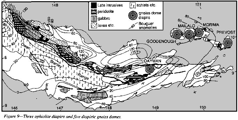 |
The Papuan ophiolite belt consists of four separate diapirs, 150 to 90 km long each making an arc ten kilometers or more south-westward, and the group makes a 600 km arc bowed to the southwest. The gravity maximum for each arc is on the chord of the arc 70 to 100 km back from the front. No ophiolite outcrops in Milne Bay but the 120 milligal Bouguer anomaly (the same as the other three ophiolites) suggests massive rock at shallow depth there.
The fault against the Owen Stanley metamorphics is steep, at least at the surface, and the gravity anomalies suggest that it continues to be steep in depth.
Cataclastic texture, high grade amphibolite, granulite tectonite, and mylonite occur near the Owen Stanley fault and its Timeno branch, but such features may be related to the emplacement of the ophiolite. or to the later global torsion system here.
The ophiolite diapirs were emplaced in the late Cretaceous (presumably Campanian, the same as the others) and each consists, in ascending order of tectonized peridotite, cumulate peridotite, gabbro, basaltic lavas, and late tonalite intrusions. The most abundant rock is harzburgite, which is mainly olivine (Fo 92) and 20% - 40% enstatite with some chromite. Intrusive veins of dunite and orthopyroxenite occur. The cumulates include chromitite, dunite, harzburgite, wehrlite, lhenolite, and ortho- and clino-pyroxenites. Next are several kilometers of gabbro, granular cumulate below and ophitic above, with augite, hypersthene, and hornblende and calcic plagioclase. The cumulate, basalt, and tonalite were certainly intrusive magmas, and occasionally intrude the ultramafics.
Sheeted dikes have not been observed. This may mean that the ophiolite ascended along the southern margin of the Solomons sphenochasm, and that the continued rapid extension there moved New Britain northward rather than repeatedly rift the ophiolite, and that the rising basaltic magma is now the floor of the Solomons Sea, not as sheeted dikes in the ophiolite.
Sodic feldspar appears in the highest zones below the submarine spilite, pillow lava, massive basalt, andesite, and dacitic pyroclastics. Pelagic sediments have not been reported. Last were numerous intrusions of quartz-hornblende diorite, monzonite, syenite, and tonalite (these may be feeders for the pyroclastics) and zones of deuteric alteration and silicification (Davies and Smith, 1971, Rodgers, 1975).
Estimates of the thickness of the Papuan ophiolite have been as high as eight km, but this may be four times too high.
The current dogma, that the Papuan ophiolite is obducted mantle, is simply a theoretical meme, and misfits the field geology and gravity field. It is amazing that this body [of evidence] was the paradigm on which the obduction concept was founded and followed by a flock of academic sheep who have never been to Papua!
The New Caledonia ophiolite is an extension of the Papuan ophiolite. All who have visited New Caledonia have been impressed with the identity, which extends to the sediments. Even the Eocene cherts of Noumea look as though they could well have been transported from Port Moresby. The reconstruction in Figure 44, p. 65 shows their direct tandem continuation.
The thrust contact between the ophiolites of Papua and New Caledonia with the ophiolites over the sediments is not disputed - only the dip of the contact-steep diapiric or flat obduction. Field data and gravity favor the former, only creed the latter because current dogma regards the Papuan ophiolite belt as a huge obducted sheet shallowly dipping to the northeast. Indeed the Papuan Ophiolite is the type area on which the obduction concept was founded.
An important fact emerges in review - time-incidence of ophiolites is not random. The last ophiolites occurred world-wide at the end of the Cretaceous when Earth expansion became rapid. Troughs below depths of carbonate solution yielded radiolarian cherts, then deep rifts whence vast volumes of ultrabasic magma gushed to the surface, sealing the rifts as it cooled. The Tethyan orogeny ensued, the equator migrated 30o from France to Kenya, and the climatic switch extinguished many biota.
Like ophiolites, Flood basalts are not random in time. They indicate more rapid crustal extension.
The term melange was first used by Greenly (1919) as a descriptive name without any genetic implication, and others have used it for both sedimentary formations (olistostromes and slump chaos) and in a tectonic sense for a chaotic mixture under the sole of a nappe, or in a megashear zone. To Raymond (1975) melange is simply a mappable body containing exotic blocks.
Without restricting its general definition, the category of melanges which concerns me here are megashear melanges - megabreccias in global torsions which cut through continent and mantle with large exotics, some as large as city blocks, ophiolitic slices, and usually with a serpentinite matrix, such as are typical of the several megashears of the Tethyan Torsion (Chapter 4). Such a melange is the normal outcrop pattern of a major megashear with transverse extension.
The Arakapas megashear melange, which strikes across southern Cyprus is up to 10 km wide containing serpentinite shear zones up to 500 m wide, and some mylonite. Windley et al., (1990), reported that the Tethyan shear zone near Turfan is a mylonitic melange up to 3 km wide. 160 km farther west the northern suture is represented by a 6-km-wide sub-vertical deformation zone, the center of which is a 500-km-wide belt of tectonic melange with mylonite juxtaposed with unmetamorphosed mudstones. Such melanges occur in many places along the Tethyan Torsion in the Himalayas and Tibet.
On Burma's Mt Victoria, steeply-dipping biotite and graphite-schists with greenstone and marble are sheared against broken recumbent Camian turbidite, then serpentized harzburgite, then pillow basalt with blocks of Triassic flysch, sheared against Albian carbonaceous limestone with a basal conglomerate on Carnian flysch, basalt, and ultramafics, then Maastrichtian conglomerate overlying Triassic with granite and dacite exotic blocks, then Lower Eocene limestone shale and sandstone, faulted against 100 m blocks of Triassic sandstone and Senonian necritic limestone, pillow basalt, conglomerate and chert; and so on. This steep section then repeats itself. House-size blocks, fault horses, and exotic boudins are typical of transcurrent movement in an expanding environment. The displacement of this megashear must he quite large, estimated by MitchelI (1993) to be 1100 km.
The Sorong shear zone (Figure 43) is a chaotic cataclastic jumble of many kinds of rock, varying from a 10-km granite block near Sorong to fine breccias of sundry igneous rocks, pelagic and reef limestone of several ages, slate, quartzite, schist, hornfels, mylonite, and tectonic breccia without sedimentary matrix. Many blocks can be identified to regional formations but some are quite exotic. Visser and Hermes (1962) described it as a chaotic pell-mell of many Mesozoic and Tertiary formations-a huge tectonic breccia with extensive mylonite.
The western side of Masirah Island (Moseley and Abbott, 1979) is a melange 5 km wide - a mega-breccia with blocks of various members of the ophiolite complex, up to two sq.km in area, along with scattered blocks of Valanginian-Cenomanian limestone in a sheared serpentinite matrix. The shearing trends parallel to the melange, which differs from Hawasina type melange (which is a chaotic melange below the advancing Semail extrusion) in that ophiolite blocks, which are not present in the Hawasina, are dominant. The contact zone of the melange and the normal ophiolite complex is sub- vertical and consists of sheared serpentinite and gabbro up to 100 km wide. The contact zone is jagged, with transverse steps as much as 1 km without break in a directly adjacent gabbro block in the melange. Near the melange many dikes are dragged to trend parallel to the megashear. The largest limestone block in the melange, Jebal Suwahr, 2 km long and rising 100 m above the surrounding breccia, is a pale-grey crystalline sparsely fossiliferous limestone. Other limestone blocks have interbedded marls, commonly strongly deformed by pre-melange minor folds. Chert blocks are abundant, commonly in contact with marly limestone and blocks of pillow lava.
In the heavy rainfall country of the tropics, melange zones tend to be deeply eroded and crop out simply as a straight river valley with an occasional large exotic block.
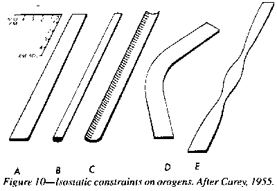 |
Orogenic belts,
in many places, are bent-often at a sharp angle. Forty years ago, I asked
whether these were impressed strains, or the belts were born bent. Folds
may die out at a decollement (Figure 15, p. 43), but oroclines involve
the whole lithosphere (Figure 10). The Earth's surface is governed
by gravity. Departures above or below the geoid rapidly conform. A in Figure
10 shows the size restraints of an orogen. Lithosphere compression or extension
is constrained within the bounds of B. C is impossible. But there are no
isostatic constraints on D or E. I found that most oroclines were
indeed impressed bends, and that unwinding them went far toward reproducing
Wegener's Pangea (Carey, 1954) (Figures 74, 78).
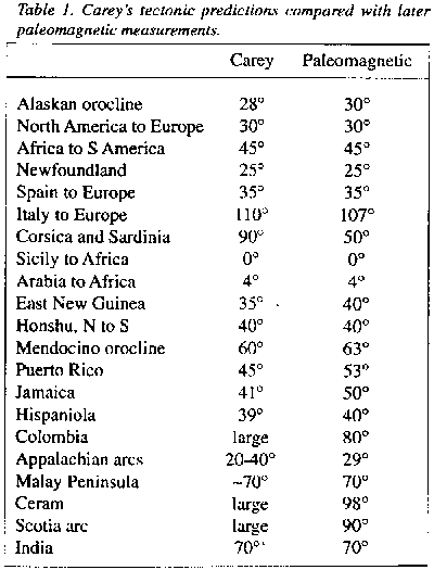 |
Many such rotations were subsequently tested by paleomagnetic measurements - various rocks, different ages, on several continents, by numerous independent workers. In every case my published predictions were confirmed. These oroclines, the gross melanges, and the major Campanian ophiolites, all correlate with the global Tethyan Torsion of Chapter 4.
Where an orogen becomes completely detached from its associated craton, it may be very substantially lengthened as well as bent. The Kurile arc and the lesser Antilles are examples of such orotaths. When reassembly of the cratons is made, such arcs must be appropriately reduced in length in the reconstruction.
Three kinds of structure may produce such bends in orogens:
(1) A rising diapir usually pushes aside the accompanying surface rim, a concentric arc, which increases in bowing as the diapir rises, usually asymmetrically to one side. Wezel's krikogens are of this kind; also the bending of the Appalachian and Honshu arcs, the East Asian arcs generally, and many others.
(2) When a craton splits and angles away from its counterpart, the same angle appears in the attached orogen; the Baluchistan orocline between India and Arabia, and Arabia to Africa are of this type.
(3) Where an orogenic belt becomes completely detached from its associated craton, it may bend around the mantle diapirs on one side of it as a krikogen; the Banda and Scotia oroclinotaths are typical.
The Benioff zone is commonly depicted as an inclined plane, generated by a decade of earthquake foci, dipping at some 60o from a trench to below an orogenic belt. down to depths of 700 km or less. The plane is developed by drawing a vertical plane transverse to the center of the orogenic arc, and projecting earthquake foci normally onto this plane.
When a decade or so of Japanese foci are plotted on twin diagrams so that they may be viewed stereoscopically, they generate, not a dipping plane, but a spoon-shaped surface which slopes down toward the center of the Sea of Japan, where the heat flux reaches a maximum. In plan, the trenches when the Benioff zone reaches the surface form a series of arcs which bow outwards to the Pacific - logical if the center of the arc is a rising diapir pushing outwards, but how can a subduction thrust of the Pacific toward Asia produce such a pattern?
The Benioff zone is the boundary between a hot rising diapir (represented by the Sea of Japan) and the cold stationary crust of the Pacific Ocean - a spoon-shaped fracture system which surfaces in an arc-trench and tapers conically toward the source diapir. Heat flux peaks over the diapir and diminishes toward the Benioff zone.
Shallow earthquakes diminish in frequency toward 300 km, then, after a zone of seismic quiet, increase again to nearly 600 km, beyond which they rapidly decline to 700 km. Deep earthquakes puzzle geophysicists because stresses there should relax by flow before brittle fracture.
But this can be false, if the rate of loading is rapid enough. Silliputty flows if left to deform under its weight, but, struck by a hammer, it is brittle. Water fractures when pits are dug out with a fast propeller (cavitation). Relaxation time is elasticity divided by viscosity. (1011 seconds for upper mantle,10-2 s for silliputty,10-12 s for water).
Lopevi Volcano had been dormant since 1939 but erupted violently on July 10,1939, which led to an invitation from the French and British Resident Commissioners of the Condominium of the New Hebrides to convene a meeting in Vila of Claude Blot (the Maitre Geeophysicien from Noumea) Ronald Priam (Vila's Chef du Service des Mines) Robin Curtis (New Hebrides Geological Survey) and John Grover (Director of the Solomon Islands Geological Department). The Resident Commissioners posed the question:
Vulcanologists and seismologists seek precursors that might give a few hours warning of impending calamity, such as from time to time kills hundreds, even thousands. Blot now offers hope of months of warning. He has studied hundreds of sequences, with considerable success and some false warnings.
Table 2, from
Grover 1994 (p.164 in the preprint) lists some of Blot's many forecasts
of volcanic eruptions in the southwest Pacific.
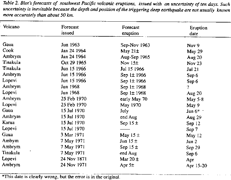 |
Even if only partly right, this work should be prosecuted with vigor. But instead of being financed to pursue this study, to sharpen the accuracy of prediction, Blot has been scorned by his French masters, ridiculed, and transferred to inactive central Africa from the Vanuatu Vulcanological Observatory, which he had directed. Shame on the self-confident establishment!
Concerning the November 1965 eruption of Tinakula, Blot warned the Eastern District Commissioner on October 29, who sent a ship which arrived on November 7, to evacuate the local people. At 9 pm on November 23 the volcano exploded, beginning another period of violent activity.
The great August earthquakes of Santo were even more dramatic. On August 12, the New Caledonian Director of Messageries Maritime telephoned Blot because of his concern for his ship Le Tahitien which had just tied up at Luganville on Santo, following Blot's earlier expectation of a great earthquake crisis on Santo. Blot replied that the risk was real and that a tsunami would almost certainly be generated. It could be dangerous for Le Tahitien to be in shallow water in the narrow channel between Luganville and the long narrow offshore island. The director said that the passengers were going ashore. Blot advised to have them recalled immediately and get the ship out to sea. Blasts on the siren brought the passengers running, the ship cast off and headed for the open sea just in time. The Richter 7.7 earthquake struck, and the docks cracked and subsided where the ship had been moored, and also the predicted tsunami came.
On December 30, 1977, Blot, from Wellington New Zealand, issued to French and Italian vulcanological authorities a formal forecast of a violent eruption of Mt. Etna due 340 ± 15 days later. It occurred 353 days later! - the response: No mention whatever of the prediction!
On December 6,1982, from his home in France, Blot issued to French and Italian authorities a formal forecast giving 115 ± 15 days warning of a violent eruption of Mt Etna, which would produce "a major lava flow" It occurred 112 days later, and will be remembered by the world-wide publicity of the efforts to stem the lava flow. This time the prediction was mentioned as "nothing but a stroke of luck"!
Etna's companion, Stromboli, had been quiescent for 8 years since erupting between December 1985 and April 1986, but following an earthquake (5.8 magnitude) on January 5 1994, Blot warned of an eruption to come in late April, probably commencing with explosive phases followed by lava--of course ignored. But on April 14, seismometers began recording very strong volcanic earthquakes, so climbing the volcano was forbidden and the approaches were protected by carabinieri. On April 20 an eruption sent ash plumes 250 m above the volcano, most of the ejectamenta falling back into the pit, but sometimes the entire NW rim of Crater 3 was covered with pyroclastics and bombs rolled down the Sciara del Fuoco. On April 23, Crater 3 erupted more strongly with larger ash plumes and in-candescent columns to 150 m depositing abundant incandescent matter into Sciara del Fuoco. Crater I, which had not been active, also erupted. Another stroke of luck?
Many (Walker and Dennis 1966, Mogi l973, Harry Green 1989 and 1990, Yoshioka et al. 1992) blinded by the subduction creed, latched on to the coincidence of the olivine-to-spinel transition with the 300-700 km depth of deep-focus earthquakes, and claimed that impulsive volume reduction at the transition caused them. But first-motion study of seismograms failed to produce any indication of implosion. The spurious subduction hypothesis had led them astray.
Not an olivine-to-spinel transition, but the reverse spinel-to-olivine transition, which must occur in rising diapirs, and could produce a hammer-blow in those regions where the rate of volume increase could not be absorbed by flow. Once the spinel-to-olivine process starts, the volume increase transition could accelerate and become impulsive.
The Benioff zone is the locus of potential shear where the upward drive of the heated diapir is resisted by the colder country rock. The addition there of an impulsive 5% expansion surpasses the strength of the rock triggering a deep focus earthquake, which propagates at seismic speed.
The severe overstress from the volume increase propagates outward as a stress-increment front. In uniform conditions the front would be a spherical surface. But conditions are not uniform. In addition to the lithostatic gradient from the weight of overburden, the diapiric side is hotter and therefore relaxes more rapidly (relaxation time decreases logarithmicly with absolute temperature). Also the Benioff locus marks the transition from the diapir tending to rise and the colder country rock resisting that rise.
For the first few hundred kilometers above the initial deep-focus shock, no further earthquakes occur, partly because propagation increases the surface area of the stress increment front, and partly because the temperature allows relaxation before shear strength of the rock is reached. Hence the non-seismic zone between deep and intermediate earthquakes.
But at some 300 km depth, the rate of stress build-up of the advancing front may exceed the rate of stress relaxation, triggering an earthquake on the Benioff locus of stress-difference, because of the country rock resistance to the rising diapir local conditions may also be important. Such failure will still be in shear, because tension failure cannot occur below the depth where the weight of overburden equals the shear strength of the rock.
In many diapiric regions, deep-focus earthquakes are not recorded, so the Benioff zone only appears down to some 300 km. Such could be regions of slower diapiric rise, so that the excess pressure from the spinel-to-olivine expansion proceeds sufficiently slowly for the over pressure to relax without reaching fracture, but failure does occur at shallower depths where temperature is lower and stress relaxation orders slower, triggering a shallow earthquake or volcanic eruption.
Immediately prior to a volcanic eruption, the ground does swell, and perhaps this also occurs before earthquakes, indicating the surface arrival of the expansion front from the impulsive spinel-to-olivine transition some seven hundred km below.
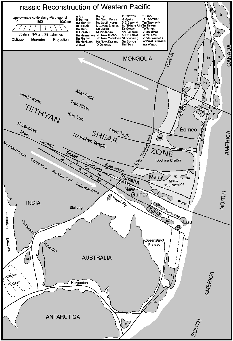
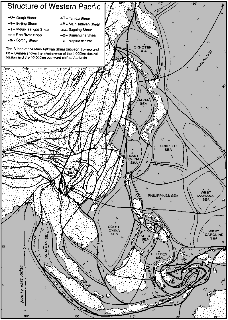