CHAPTER 4: BOUNDARIES AND ROUTES
INTRODUCTION
The major political boundaries of the East Midlands were established during the seventh century and during the Viking invasion. Some of the boundaries followed geographical divisions but most of them have been defined by political struggles. All of them come from the competition for land or the tribute of land. As early as the Tribal Hidage, areas were assessed in units of 12 which followed the Mercian duodecimal monetary system (Hart, 1977, 46). Before the seventh century, the boundaries were defined by administration and especially taxation.
BOUNDARIES
The northern boundary of Mercia was established during the wars with Northumbria but was primarily defined by geography. The boundary followed the River Humber and its tributary the River Idle into the Pennines. The boundaries of Lincolnshire and Nottinghamshire still follow the old course of the rivers (Revill, 1976, 48). The River Humber and the marshlands around it divided the people on its northern and southern banks. In the early eighth century, a Northumbrian writer like Bede wrote about his area as Northumbrian and the south as Sudanhymbra. This term was no longer used in the late eighth century and was replaced by Mercians, or "people of the border", which might mean the River Humber (Hunter-Blair, 1948, 105-113). The success of the Northumbrians in establishing control south of the River Humber rules out geographical determinism but their unsuccessful control of the region demonstrates the problems with communication which the River Humber posed. The battles during the seventh century were fought at Hatfield which was on the River Idle and on the River Trent, on a narrow strip of land that gave access to the north and south.
To the west, the northern boundary of Mercia ran from the River Humber to Dore which is the modern boundary of Derbyshire (Ingram, A.S.C. 829; Ingram, A.S.C. 943). Bakewell was close to the northern boundary (Ingram, A.S.C. 923) and Roman and earlier earthworks in this area suggest that the boundary followed earlier boundaries between the British tribes of the Coritani and Brigantes (Hunter-Blair, 1948, 121; Millward and Robinson, 1975, 118-120). The borders of the kingdom of Lindsey were also drawn by geography. The sea, the River Humber estuary and the marshes of the River Trent and River Witham made it an island-hence the name Lindesege or Lindes island. The natural barrier of the Fens also helped set the boundary of Lindsey.
Boundaries take on an important meaning in their use and recognition and because of the battles over their definition. As long as they were borders of hostile kingdoms, they could be fortified. Battles fought near these frontiers show them to be very important to the kingdoms involved. Boundaries were probably neutral ground where kings could meet since neither king would be far from his own territory and they were not expressing subordination to the other or taking risks in a long journey into the other's kingdom. In 702, the kings of Mercia and Northumbria met at Austerfield to settle a dispute (Giles, H.E., XXXXVI-XXXXVII). The boundaries also existed to separate different political attitudes and reactions.
Boundaries defined by hostilities became the peacetime boundaries for administration purposes and ceased to be lines on a map which kings fought over. They determined where and to whom you paid tribute, in which court your cases were heard and what links of patronage and alliance you sought. Administrative boundaries were important in defining communities and turning groups on either side towards different lords and centres.
The boundaries of the kingdoms were established by physical features like the rivers or old boundaries like Watling Street. But these features may represent older estate boundaries which maintained the central fortifications. On the boundary of Leicestershire are Mancetter, High Cross, Caves Inn, Medbourne and Willoughby-on-the-Wolds which were all strategic sites and established in the Roman period where the Roman roads crossed old estate boundaries (Phythian-Adams, 1977, 78). This will occur when, as in south Leicestershire, a major Roman road like Watling Street, would have been a permanent feature or in Rutland, where old estate patterns remained. Estate patterns have changed since the Roman period and other political factors have affected the modern shire boundaries. But these are a reminder that the frontiers are defined not only by the hostile actions of kings but also by local landownership.
GEOGRAPHY
The pattern of settlement in Roman Britain shows the division between the higher elevations and the lowland areas. The areas that were settled were mainly in the lowland areas and the settlements were spread out along the Roman roads. The river valleys such as the River Trent, the River Soar and the River Welland were all heavily settled. There appears to be some relationship between the Anglo-Saxon settlement pattern and the Romano-British settlement pattern. They both avoided the higher elevations and the heavily forested areas and both groups seemed to have preferred to be near communication routes. Most of the major Romano-British centres in Eastern and Central England have at least one Anglo-Saxon burial site nearby. The suggestion that the Anglo-Saxons avoided the settlements of the Romano British is not true because the evidence shows that the major centres must have been recognisable to the Anglo-Saxons and were inhabited during the settlement period. The villas are the only aspect of Roman Britain which could have decayed beyond recognition and repair.
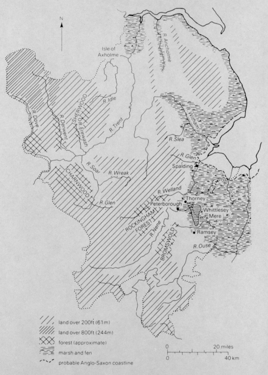
Figure 6 Topography of the East Midlands from P. Stafford, 1985.
GEOLOGY OF THE EAST MIDLANDS
The East Midlands, except for Derbyshire, is part of the lowland zone of England. The combination of the chalk, limestone, grits and sandstones with the alluvial soils and gravels from the river valleys and the lowland clays and areas of fen and marsh were important factors in determining the settlement patterns of the East Midlands.
To the south, the Chilterns were generally inhospitable to agriculture because they are poor chalklands and part of this chalkland is found in the Lincolnshire Wolds. Although the chalk was poor for farming, the edges of it were desirable areas for pasture, especially for sheep. The areas which were difficult to settle in were the gritstone plateau and limestone uplands of the Derbyshire Peak and west Nottinghamshire, where settlement was sparse except in the river valleys. The sandstones of Leicestershire were not very difficult to settle on and the river valleys were also favoured for settlement. The oolitic limestone ridge runs down the centre of the region and begins in Lincolnshire and runs south into Northamptonshire. It was a source of building stone which was quarried at Ancaster and Barnack and also a source of ironstone on its western edge at places like Scunthorpe. The limestone soils themselves might be poor for farming but the spring line within the soils supported many settlements. An example of this is on the western edge of the Lincolnshire ridge. These areas are not the same impassable barriers which exist in other areas of the British Isles and their impact on settlements and their densities is still seen in the Domesday Book.
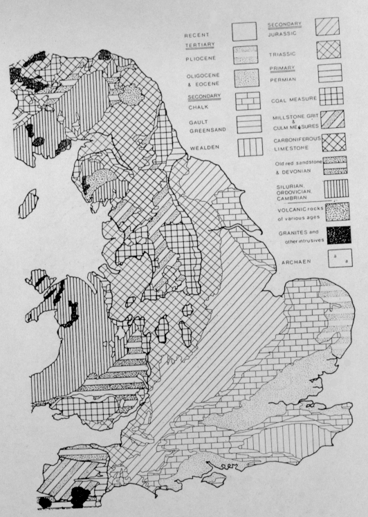
Figure 7 Geology of the East Midlands from D. Hill, 1981.
Descriptions of the landscape in eastern England during the Anglo-Saxon period are rare. They usually appear as a backdrop to miraculous occurrences or to the activities of saints. The earliest description of the Fens, which stretched around the Wash and cut off eastern England from East Anglia, is from an eighth century East Anglian monk:
"The great fen begins on the banks of the River Granta...swamps and bogs, an occasional black pool, exuding dark mists, sprinkled with islands of marshy heaths and crisscrossed by winding waterways" (Colgrave, 1956, XXIV).
The thick fenland fogs were also recorded in the eleventh century when they hid monks from Ramsey and Ely from each other when they were both on a quest for the relics of St. Felix. Guthlac lived on the island of Crowland because of its inaccessibility and Abbo of Fleury stated that the Fens in the tenth century were havens where hermits could find solitude (Migne, 1880, 139). These sources do not give historians and archaeologists a good description of the Fens around the River Witham, the River Welland and the River Nene when they describe them as desolate and inhospitable.
Guthlac's island in the marshes was a place of terror and his marshes are like those from the poem Beowulf. This picture is formed by a magical view of the world and the fens were a place where enemies lurked and was avoided by all but saintly or political exiles. They were not popular with the agricultural communities of eastern England and it is these communities which describe the fens as "the paths of exile...the unknown land...the dangerous fen path" (Gordon, 1926, 28-29).
c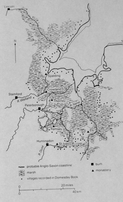
Figure 8 Marshes and Settlement around the Wash from D. Hill, 1981.
The marshes and fens were a barrier to settlement and were more extensive in eastern England during the Anglo-Saxon period than they are now. The Fens surrounding the Wash are a flooded alluvial plain. To the seaward side, the sedimentation produced a silt fen bordering the Wash and inland were the peat fens which were dotted with islands of boulder clay. The peat fens were unstable and prone to flooding and few Domesday villages are recorded on it. Settlements were confined to islands like Thorney and Ramsey. The silt fens were settled and a line of the Domesday villages seem to mark the original coastline, which was further inland than today. The post-Roman flooding which produced the fenlands around the Wash also affected the courses of rivers and changed the coastline. During the Anglo-Saxon period, villages such as Boston and Spalding were coastal settlements and the River Bain and the River Slea flowed to the sea. Marshes and fens stretched up rivers, like the River Witham almost as far as Lincoln. The Wash rivers were important for settlement and the Lincolnshire place-names on the high silts like Stenning and Spalding may be among the oldest of English names. Their position though, shows the limits that were placed by the marshes and fens.
The fens and marshes were also a feature of the lower River Humber tributaries. These extended the barrier to communication deeper inland. Small stretches of reed beds are all that remain of the Fens which stretched around the mouth of the River Trent. Before the seventeenth century drainage projects, the valleys of Ancholme and Axholme were marshy and heathland and sand joined the marsh to inhibit settlement, agriculture and movement in North Lindsey.
After the Roman period, flooding along the Lincolnshire coast increased because the protective shoals had eroded and before the end of the Anglo-Saxon period, the Lindsey coast was protected by a sea bank (Owen, 1974-75, 45-46). This bank is referred to after the eleventh century at places like Skegness, Mablethorpe, Friskney but it was in existence by 1066 since the Domesday Book records settlements on it. In southern Lincolnshire, a similar bank linked the estuary between Holbeach and Fleet and the Domesday Book records saltpans existing at Fleet outside the sea bank (Hallam, 1954, 15 and 17-18). Nothing is written about the construction of these banks but they, along with the other earthworks of the early Anglo-Saxon period, are proof of the engineering and the organizational skills of the settlers during this period.
Few features have played a bigger role in determining the settlement pattern of the East Midlands than rivers. To the north there is the River Humber and its marshes which has difficult currents to cross. The River Trent cuts the region in half and like the navigable rivers of the Wash, it provided a line of communication deep into the interior. When invasion from the sea was as important as trade, these rivers into the interior were a mixed blessing. Communication along these rivers might be important but they also were barriers between the neighbouring communities. An example is River Trent dividing Lincolnshire and Nottinghamshire for part of its course.
The River Nene and part of the River Welland once flowed out to the sea along the boundary between Lincolnshire and Norfolk (Barley, 1938, 21). As the Wash rivers have showed us, many of the river courses have changed since Anglo-saxon times even though their original course may be marked by old boundaries. At Newark, the River Trent has shifted westwards; in the late Anglo-Saxon period when the parish boundaries were laid out, the eastern branch of the River Trent at Newark was the main course of the river (Rogers, 1974, 16). Other rivers have changed drastically such as the River Nene which was wider and shallower before the eighteenth century embankments (Steane, 1974, 135).
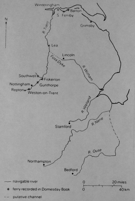
Figure 9 Water Communications and Ferries from P. Stafford, 1985.
Rivers also provided important settlement sites. The valleys of rivers like the River Trent, the River Welland and the River Nene had fertile soils and had good drainage. The gravel terraces were favoured by people for settlement long before the Anglo-Saxon period. The settlement history of the River Nene begins before the coming of the Anglo-Saxons and can be traced all the way back into Neolithic times. The gravel terraces were dry and easily tilled and had access to good water supply especially at spring line sites such as Irthlingborough, Twywell, and Rothwell. It is through the valleys of the River Dove, the River Derwent and the River Erewash that settlement penetrated the Southern Peak and the southern tributaries of the River Trent and the River Soar provided many sites.
Many of the East Midland rivers were navigable by shallow-draught boats in the early Middle Ages with the River Trent navigable as far as Nottingham and the River Welland navigable as far as Stamford. In the eleventh century, anyone who impeded the passage of boats on the Nottinghamshire Trent was subject to a fine of eight pounds (Darby, 1977, 301). In the late Middle Ages, Lincoln could be reached by boat along the River Witham and the canal linking Lincoln to Torksey judging from the close links between Lincoln and Torksey in the Domesday Book (Darby, 1977, 301).
These rivers provided access to the East Midlands not only to trade but also to invasion. It was along the rivers of the Wash and River Humber that many of the early Anglo-Saxon settlers came. In the ninth, tenth and eleventh centuries, these rivers also made the Viking invasion easier. The Viking armies could travel along the River Trent from York and winter at Torksey or to Ingleby near Repton in Derbyshire and never be far from their boats (Ingram, A.S.C. 873-74) and Northampton was a centre because they could reach it by boat along the River Nene. To defend themselves from the Viking invasions, the West Saxon kings of the early tenth century tried to block the passage of these rivers. Edward the Elder constructed fortified sites at Bedford, Stamford and Nottingham (Ingram, A.S.C. 918; Ingram, A.S.C. 921; Ingram, A.S.C 923).
By the time of the Domesday Book, the Trent/Humber route was so well established that the burgesses of Torksey was required to provide a boat to carry the sheriff to York when necessary (Darby, 1977, 301). Not all Anglo-Saxons travelled by boat though. Useful as they were for the movement, the rivers also channelled the other communications routes of the East Midlands. The bridges and crossing points at the rivers were centres for urban development. Stamford was the "stoney ford" where the Roman road crossed the River Welland and Nottingham is situated where the London to York road crossed the River Trent. This road was so important in the eleventh century that it was accorded, along with the River Trent and the Foss Way, the king's special protection in Nottinghamshire (Darby, 1977, 301). Where there were no bridges or the rivers were too wide, the people used ferries. Littleborough was the ferrying point where the Roman road linking Ermine Street from Lincoln to York crossed the river. Other ferries on the River Trent by the late eleventh century were at Gunthorpe, Fiskerton, Southwell, Lea and Weston-upon-Trent (Darby, 1977, 301-302). The wide estuary of the River Humber was crossed by two ferries from Grimsby and two from South Ferriby, as well as from Barton and Winteringham (Darby, 1977, 301). The local Lincolnshire communities complained to the Domesday Book surveyors in 1086 that the new Norman lords were taking new tolls on bread, fish and hides so we can by this date, the ferries carried trade across the River Humber.
Forests have always been assumed to be a major feature of the early landscape. Estimates of their size in the Anglo-Saxon period is very difficult since the Domesday Book is the only source we have. The main problem is the statistics on woodland are difficult to interpret. Wood is recorded in the survey in terms of the number of pigs it would support and outlying stretches of woodland were not recorded because the survey was more interested in the central estates where dues were paid. More important than the problems of the Domesday Book is the assumption that the history of settlement was a battle against the forest. This assumption states that the forests in the early Anglo-Saxon period were very large and were being gradually reduced by clearance up through the eleventh century. This assumption has been challenged and a theory developed which states that the clearance of the forests and settlement had progressed far by 400. Peat pollen analysis in Derbyshire seems to support this theory which suggests that in this area, agricultural activity was in decline by 400 and was not reversed before the tenth century (Tallis and Switsur, 1973, 743-751).
Sherwood and Charnwood forests were still very large in the eleventh century and Sherwood forest is in a charter granting land at Sutton and its name scirwuda means it may have been a royal forest (Gover, Mower and Stenton, 1940, 10). In the Domesday Book, Leicester forest is called "the woodland of the shire" but its actual name was Heres wode or "wood of the army" (Darby, 1977, 187). Since the army may have been the Danish conquerors who settled around Leicester, the forest may be the hunting ground of a ruling group. Forests were an important feature of the Derwent valley, south of Ashbourne and east of the River Dove. In this area, names ending in leah (clearing) suggest that clearance during the Anglo-Saxon period was occurring (Cameron, 1966, 199).
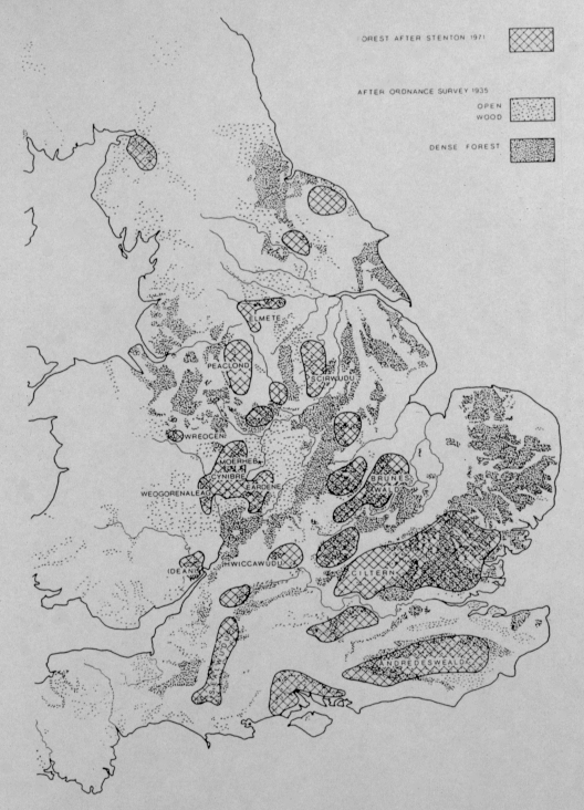
Figure 10 Forests in Britain from D. Hill, 1981.
Around the year 1100 there were four main roads which travellers used which was under the king's special protection. They were Watling Street, Ermine Street, the Foss Way and the Icknield Way. The Leges Edwardi also refers to other important local roads from cities to cities in which men could go to markets. The authors of the Leis Willelme and the Leges Edwardi Confessoris were not attempting to make a statement about the road system of England but instead were highlighting the fact that in the Anglo-Saxon period the great roads of England ran through the East Midlands and that these main roads have never stopped affecting the history of the area. The Roman routes which these authors singled out reveal their antiquarian interests as well as their use in the late eleventh century for communications.
The East Midlands has always had many prehistoric routes like the Portway running through Ashford and Wirksworth in the Peak, the ancient Wolds trackway in Lincolnshire, Sewstern Lane running from East Anglia to the Midland Plain running through it. The Romans re-used and added to these to form a network of major routes and minor roads. An example of this is Watling Street, Ermine Street which links York to Lincoln and the road from Buxton to Little Chester near Derby. The importance of these routes in the early Middle Ages and their existence in Roman times, does not mean that they were in constant use or were significant during the Anglo-Saxon period.
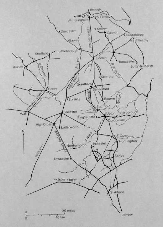
Figure 11 Roman Roads in the East Midlands from I. Margary, 1976.
The Roman road which linked York to Lincoln was in use during the seventh century but it was used for the movement of armies in the battles between Mercia and Northumbria. During the sixth century, burials were dug into the surface of the Ermine Street at Hackthorn (Eagles, 1980, 182) and others have been found on Watling Street at Kilsby and Aldwincle (Brown and Hannan, 1978, 91). This does not mean that these roads were still busy routes. The Anglo-Saxons may have buried their dead on the boundaries so that the spirits would protect that community. Burials that were associated with the Roman roads may mean that these roads were used as boundaries. Their construction made them obvious boundaries and they may have functioned as property boundaries in the pre-Anglo-Saxon period. Ermine Street was the boundary to a line of parishes in northern Lincolnshire and was already a boundary of the estate of Haddon in Huntingdonshire in 951 and parish boundaries follow the Foss Way near Claybrooke and between Lincoln and Burgh-le-Marsh (Margary, 1967, 238; Steane, 1974, 62 and 64). These boundaries may show the continuity of property boundaries and the administrative structures which were associated with property and its ownership from Roman Britain to Anglo-Saxon England but they do not provide evidence for their survival as long-distance routes in early Anglo-Saxon England.
Important tenth century towns were often close to old Roman roads. Examples of this are Derby which replaced the Roman site of Little Chester and Stamford is downstream of Ermine Street's crossing of the River Welland and is situated where the river could be forded. These routes served the needs of the communities as well as helping to channel them. The continued used of Roman roads between the sixth and ninth centuries does not mean that they were significant long-distance routes. These routes may have had little to do with the economic needs. They were important for the movement of armies in the seventh century and in the eighth and ninth centuries when the Mercian kings required the owners of land around the roads to construct bridges. Literary evidence from the kings and their courts would be expected to stress military rather than economic use of the roads but there are other reasons for thinking that some roads were not important at this date. Trade was centred on coastal sites in the seventh and eighth centuries and usually dealt with scarce or imported goods. Trade routes were not very important and the movements of peasants or wandering monks may not have been important enough to maintain them. The method used to construct the Roman roads meant that they survived and were used in the economic revival of the tenth and eleventh centuries. The importance of the road system in the East Midlands may have helped with the revival, as did the local river communications.
CONCLUSION
The boundaries of the seventh century in the East Midlands were established by the geography and geology of the region as well as political factors. Rivers and marshes were two of the main factors which contributed to the establishment of these boundaries. The northern boundary of Mercia followed the River Humber and River Idle while Lindsey's boundaries followed the River Trent, the River Witham and the North Sea Coast. The political factors were also important because they established boundaries by treaty or by wars.
The geography of the region is very diverse between the lowland, arable lands and the higher, less arable lands. Both the Romano-British and the Anglo-Saxons avoided the upland area and seemed to have settled near the natural and man-made communication routes. The maps at the end of the Gazetteer agree with this theory but why was the land north of the River Trent not settled more? The land in this area was very good for farming. Was it because of some political factor which is not recorded in the records (such as an unnamed group of people in the area)? Or was the River Trent a physical barrier that did not allow easy access to this area? Only more research into the region will provide the answers to these and other questions regarding the settlement and boundaries of the East Midlands.
To Go Back to Chapter 3 press 
To Continue to Chapter 5 press 
Copyright 2005 tst4eco.geo@yahoo.com