CHAPTER 3: PLACE-NAME EVIDENCE
INTRODUCTION
One problem scholars find when studying pagan Anglo-Saxon England is that places do not always retain their earliest names. An example of this one name replacing another can be seen at Derby, Derbyshire and Hibaldstow, Lincolnshire. Place-names with a Christian connotation, such as Kirton-in-Lindsey, Lincolnshire were not applied to settlements before the conversion to Christianity and it is unlikely that names like Kingston-upon-Soar, Nottinghamshire were in use before the sixth century even though the dynasties of the various kingdoms can be traced back to an earlier period. Also, many places called New-, like King's Newton, Derbyshire and Newark, Nottinghamshire were unlikely to have been created when the first settlements were being made. Another category, the geographically related place-names such as Sutton Bonington, Nottinghamshire would have come into use later than the sites from which they came from and some names with an ethnic background such as Scotton, Lincolnshire and Wigston Magna, Leicestershire belong to the period after the Scandinavian settlement. But the original names of the settlements from the fifth to seventh centuries have been lost but the settlements are known to have existed in that period because of the discovery of burials or domestic sites in the area of place-names from a later period. Some of the original settlements had names which had fallen into disuse before written records began. Some of the settlements failed to survive because of reasons that will be discussed later and their names may not have been applied to new settlements in the same area.
ARCHAEOLOGY AND PLACE-NAMES
Archaeology is used to establish a pattern of settlement at a particular point in time. This is because approximate dates can be given to many sites whereas it is difficult to date a place-name. But place-names give a more complete pattern of settlement for the whole period since the missing place-names are less than the gaps in the archaeological record. Combining archaeology and place-name study for this period can be very useful. Eventually place-name studies and archaeological evidence may establish an approximate chronology as to the use of place-names. There will probably be some overlapping in the period of their first use but with the newer techniques in excavation and interpretation, what is found should add to our knowledge of settlement sites and cemeteries. In addition, re-examination of artifacts already in museums should add more information. The location of new sites will increase the amount of material we have to make generalisations from but the amount of sites already known is quite large and it is unlikely that there will be any change to our understanding of the material remains of early English society. A reconstruction of those early centuries requires more than the study of artifacts and structures and must take into account all the factors that have relevance to the pagan Anglo-Saxon period.
Unlike archaeological excavations, place-names study can give both historians and archaeologists a larger picture of any area. Written sources and artistic products, such as metalwork and pottery, are the creations of specialists but place-names are usually products of the local people. The place-name records the description of a settlement or landscape feature in the language of those who lived around it. From the place-names, we can study the language and speech habits in the area at the time it was formed. Place-names can be formed from some folk-names which are combined with an element to distinguish it from other places with the same name. Examples of this are when place-names include a personal name, a feature of the topography or a type of animal or vegetation which was connected with it. The elements that denote a place or habitation site may have changed a little over time and the place-name that is given to an area probably reflects the race of people who gave the name and not the inhabitants of the area. The fact that we speak English and not Welsh and that a majority of the place-names are in English, demonstrates that there was a dominating Anglo-Saxon settlement which displaced the native British speech. Also, the large number of Viking place-names in the East Midlands proves that there was a second settlement of Danish speaking people in this area during the ninth and tenth centuries.
The majority of the place-names in England are Anglo-Saxon but many of the river names are earlier and there are a few British names in the extreme western part of Mercia. In Derbyshire, the River Dove has a British name from dubo or "the dark river". The survival of these names raises questions about the actual date in which the Anglo-Saxons settled this area. It also raises questions about the numbers of people of each race in the population and the conditions of cohabitation. The survival of some British names may prove that there was a period of contact between the Romano-British and the Anglo-Saxons in which the Anglo-Saxons learned these names. They also indicate that a physical feature which is known to a large number of people and is not owned by an individual, may rarely change its name. The place-names also emphasize the impact of currency and of ownership and a question that is asked by most scholars is how long did the Romano-Britons remain dominant and were they were treated as equals or as a subject population? The eastern part of Mercia contains many Danish place-names which create a special problem because some of these probably replaced the earlier Anglo-Saxon place-names. Among the place-names that were possibly changed are the "Toton Hybrid" group (Cameron, pers. comm.). Place-names that we know were completely changed include Derby, Derbyshire, which was Northworthy, and Peterborough which was Medeshamstede.
SETTLEMENT, SOURCES AND DISTRIBUTION
Almost all of the settlement sites that are known have been found outside existing villages. But this does not imply that the settlements of today were not occupied in the pagan period. Most modern settlements are found where cultivable soils, water supply and permeable house sites are available. These places were probably not avoided by the earliest settlers and beneath the modern settlements we should find traces of the earliest local occupation, assuming that there are any recognisable traces remaining after so many centuries of building and rebuilding. The names of some of these earliest settlements probably survive today and only where there was a break in occupation is the name likely to have been lost.
Where a settlement died out completely, its name probably died also even though material evidence may be recovered. Today these sites are called after the modern name of the parish or locality where it was found but the name probably has no relationship to the extinct settlement. The loss of the original name, if it happened in pre-literate times or if it was not included in written records, can not be retrieved.
Another difficulty is that an archaeological site may not have been associated with the modern name used for it. Apart from the possibility that a settlement which was associated with a cemetery may have become deserted, the settlement may have shifted and might have been renamed with reference to a topographical feature at the new site or possibly renamed because the original name was no longer appropriate. If renaming occurred before the original name was recorded in writing, it is lost to scholars. The present identification of a name with a site is guess work but it may only affect a small minority of place-names. Also, it must be stated again that the dating of some sites is unreliable because the chronology of the artifacts may be wrong with a margin of error of 50 years or more.
The appearance of a place-names in written records could be a dating method and has been used to date the earliest group of names from around 700 (Cox, 1976, 12-13). But written sources, especially before the tenth century, are difficult to find and even though they may establish that some of the names are definitely early, they cannot eliminate those which do not appear in them. The majority of English place-names were first recorded in the Domesday Book but most of them are older than this. But even the Domesday Book is an inaccurate record of all the place-names that were in use at that time because Breedon-on-the-Hill, Leicestershire, which was first recorded in the early eighth century, is missing from it. With the written records unreliable, it is difficult to argue that a place-name is as old as its first written record. This forces scholars to look at other methods to date place-names.
Mapping place-names on a map is a way of examining which settlements were the earliest. But we have to assume that the better soils, like the boulder clays, were settled and cleared first and the poorer soils, like the glacial gravels, were settled later. Place-names that are found on the best soils are argued to be older then those that are found on the poorer soils (Cameron, 1971, 147-163). Early attempts to map place-names in this way may have ignored other factors which may have decided the choice (and therefore the date) of the settlement sites. These factors are water availability, nearness to communication routes, the influence of existing settlements and the lack of association between soil fertility and the underlying geological drift (since it is geological map and not soil that are usually used to map this). The use of this method has been done but it has still failed to produce any conclusions about dating different types of place-names (Fellows-Jensen, 1978, 299-328).
Another method that is used is to look at the later history of the village to see if we can obtain its possible date of origin. For example, if a village was deserted in the later Middle Ages, it may be assumed that the site was always marginal and the name and the settlement were established late (Fellows-Jensen, 1978, 357-362). This method not only ignores the variety of factors which led to the desertion of the village but it also assumes that poorer soil equals later settlement and naming. The importance of administration or tax assessment of a village in the later Middle Ages has also been used to argue that the settlements that were the wealthiest and largest by that time were the oldest settlements and that those settlements which became parishes in the tenth and eleventh centuries represent the oldest settlements and that their place-names are early. There may be some truth to this but the date for the evidence for parishes and village size is from the eleventh and usually twelfth century. The development and size of the villages by this late date may be due to the reallocation of land nucleation of settlements of the mid-tenth century and have nothing to do with the date of foundation. The Domesday Book tax assessments, which were often used for this purpose, included unnamed surrounding settlements under a named village (Stafford, 1985, 75). These arguments must also take into account the relationships between settlements. In a densely settled area such as the Wash river valleys, new villages may have been established from an early date on the poorer soils and their chances of growing large were always limited because of this. The studies done by Cameron and Fellows-Jensen seem to concentrate on a single factor explanations (Cameron, 1987; Fellows-Jenson, 1978).
Accessibility by river valleys or Roman roads seems to have been a factor in the Anglo-Saxon settlement of England. These two forms of communication routes were the focus for settlements from which colonisation occurred. Early settlement was heavier in the east where smaller rivers and lesser communication routes were used more than in the west. This could also be due to the greater concentration of rivers and roads in the region. It seems that the place-names that are recognised as early do not date from the same period as the early burial sites but rather from the colonisation phase.
Most of the place-names in the East Midlands do not fall into any clear pattern regarding the rivers and the Roman roads as the burial sites did. There are early place-names along the Roman roads and along the river valleys but many of the others are scattered over the landscape and there is a heavier concentration of early place-name types in the eastern area of the East Midlands.
The model which was held until recently was based on the idea that the history of English settlement was a story of gradual expansion. The model states that the landscape was largely unexploited at the end of Roman Britain and that from the fifth century onwards it was a time of constant battle against forest and fen to found establish villages and clear area for new sites. The arrival of the Anglo-Saxons was important in the history because ethnic groups of Angles, Saxons and Jutes were undertaking new land clearance. The new groups brought with them new forms of social, political and economic organization and which dominated the existing population.
This model has affected the way place-name scholars have interpreted the place-names. If place-names could be dated then their chronology would show the pattern of human expansion, as -ham were followed by -ingaham, -ings, -tuns and so on. This model also affected archaeological interpretations on the cemeteries of eastern England. It affected the interpretations about political, administrative and estate structures and stated that the Anglo-Saxons established new areas in largely unchartered land. The model also affected the roles that were assigned to Anglo-Saxons in the history of settlement since they were seen as colonizers and settlers.
This view is changing because of the work of Barrow, Jones and Sawyer (Barrow, 1973, 7-68; Jones, 1976, 15-40; Sawyer, 1978, Ch. III). The landscape was not as empty and unexploited as the old model suggested. The boundaries and estates go back to Celtic times if not before. Place-names recorded the expansion of settlement and the changes in land organization and ownership which occurred during the early medieval period. There are two recent interpretations which emphasize the military and colonial nature of the Viking settlement in the East Midlands. The first interpretation we have shows the area settled by a military aristocracy and the second shows Danelaw peculiarities which were part of the rational legal system of a military, colonial society. The emphasis on the aristocratic organizations and re-organizations of society agree with the new model put forward by Jones, Barrow and Sawyer.
CONTINUITY FROM ROMAN PERIOD
The only thing that shows continuity as far as place-names are concerned is in some Roman places such as Lincoln, Lincolnshire which retained some traces of its pre-English name. Leicester, Leicestershire was named by the Anglo-Saxon settlers without retaining any of its older name since its first syllable has a pre-English name that may be that of a river but the name Ratae is not part of the modern name. The final years of the Roman town are still difficult to piece together but there is some evidence to suggest that it may not have been completely deserted when the first Anglo-Saxons arrived. The Anglo-Saxons established several burial sites in and near the town which had some very early pottery in them. One urn has been compared with a pot from Liebenau which was a cemetery used immediately before the migrations to Britain (Myres, 1951c, 76). If the Anglo-Saxons and Romano-Britons were living together at Leicester, there is little information about it in the existing archaeological record.
Horncastle, Lincolnshire, which was probably called Bannovalium or "a strong spur of land", has a similar first element in the English name which shows an awareness of the same local topographical feature. This was probably a coincidence and the settlers did not attempt to translate the Roman name. Also, the names ending in -Caester indicate that the early Anglo-Saxons recognised these Roman sites as strongholds. -Caester is derived from the Latin word castra and in no way can it be regarded as being a Romano-British place-name.
DATING OF PLACE-NAMES
Identifying the first use of a place-name element is impossible because the date of the first use of a name in early centuries is unknown. Only when charters became available in the 670s is it possible to determine that a name was in use at that time and possibly earlier. But early charters are rare and for some areas they are extremely few or even non-existent. The only way of solving this problem is by relating the date of the archaeological sites to the associated place-names.
Attempts by scholars to date to groups of place-names is usually an attempt to date the stages of land clearance and new settlements. Place-names scholars feel that if all of the -ham are sixth century and all the -by are late ninth to early tenth centuries, then by plotting these on a map, the expansion of settlements and land clearance will appear. Even if broad dates are assigned to the place-name elements like -ham or -by, the village may not have been founded when the name was given since place-names can and do change over time. There is no pattern to this since Bede mentions places whose names he knew in the early eighth century which had not changed by the eleventh century. Barrow, Leicestershire and Partney, Lincolnshire have changed over the centuries only in their pronunciation but this sort of change has affected the whole English language since the Anglo-Saxon period. Bede has written about Tiowulfingcaestir on the River Trent (Giles, H.E.,II, 16), which may be Littleborough but these changes can not be simply because of the Viking invasion. Physical transformation of a settlement can also change a name. An example of this is Bede's Medeshamstede which became Burch (Borough) and then became Peterborough because of its growth into an important town by the eleventh century (Ingram, A.S.C., 963). Many villages which have Viking names are so closely identical to the English named villages that they are probably old villages which were renamed after the Viking settlement (Fellows-Jensen, 1978, 327-328). Some villages still had both English and Danish names in the eleventh century which indicates that the place-name change had not stabilized (Fellows-Jensen, 1978, 13-14). Many place-names, including those from Viking settlement in the East Midlands usually record a change of ownership and not the settlement of a new village. In southern England, where tenth century documents are more numerous, it is obvious that some of the sites were called after their tenth century owner, not because he founded the settlement but because he acquired it during the break up of some larger unit (Gelling, 1967a, 5; Gelling, 1988a, 181-183).
Place-names should not be used to examine settlement history or changes in ethnic composition of the local population until the reasons why they do change are more fully understood. If place-names are to be used they must be dated (Sorensen, 1977, 2) but what can be dated is usually too broad to be used. The English place-names can not be dated earlier than the late fourth century when the first English settlers arrived. The Viking/Danish place-names can not be dated earlier than the late ninth century when the first known Viking settlements in the East Midlands were established. The problems start when we ask detailed questions about the place-names in the East Midlands such as which are the earliest English place-names which could indicate the earliest phase of Anglo-Saxon settlement? Can a group of names which indicate settlement up to 700 be identified? Can those of a later date be identified? Can the numerous Viking place-names which end in -by (e.g. Ashby) all be dated to the early stages of Viking settlement? And if so, can they be used to show changes in the landholding and in the settlement or were the changes more gradual during the tenth and eleventh centuries?
Place-names can also be used as evidence for language changes. They may indicate what changes were occurring in the ethnic composition of the population. An example is in the tenth century, the surrounding people may have called a village like Fotherby, Lincolnshire by using the Viking ending -by and not the English work -tun. Also, by using the Scandinavian ending -ar, rather than the English ending -es, it may suggest that the local people were speaking a language or dialect influenced by Scandinavian speech. The problems start when scholars argue about how large a Scandinavian settlement was necessary to bring about these changes in speech or how large an Anglo-Saxon settlement was needed in the fifth and sixth centuries to ensure that the people of the East Midlands spoke English by the eleventh century. The difficulty is understanding how languages change and whether these changes are simply a question of the numbers of settlers or the nature of the incoming community.
The aristocracy can also influence the language since if the language of the local court is English or Danish, many of the people will learn enough of the language to get by and the language of the new aristocracy would probably affect the legal terminology in the area as the Danish language did in the East Midlands. If the two languages are fairly close, as old English and old Danish were, bilingualism may occur and a large bilingual group may have caused changes to the native language. The arguments about changes coming from the invasion of a new aristocracy have been discredited by the examination of the Norman Conquest (Gelling, 1988a, 236-240). This settlement of Britain can be used as a control since it was an aristocratic settlement by a few thousand overlords. The impact of the Norman Conquest on English place-names was very small but it did have long term impact on the language. Using the Norman Conquest as a control to show the influence of a small aristocracy on language and names it seems that the Viking settlement was fairly extensive but not overwhelming, since English place-names survived and English remained the dominant language of the area. The Anglo-Saxon settlement on the other hand seem to have been overwhelming and resulted in a total change in place-names and language.
But if the Norman Conquest is used as a control settlement, then other variables must be examined. The place-names seemed to have some flexibility but this was during periods of transformation in landholding. One of these changes had occurred before the Norman Conquest with the Viking settlements which produced number of Viking place-names (Stafford, 1985, 77). A factor in fixing place-names to a site was the written record. The use of writing, especially for administrative and taxation purposes, affected all oral records, especially names. The Domesday Book and some other administrative documents were part of the process in which English place-names became permanent (Harvey, 1975, 175). The Norman Conquest occurred near the beginning of this transformation from oral to written and its impact on place-names was less than the Anglo-Saxon settlement or Viking invasions. The major landholding changes of the tenth century have left a large record of English place-names because they were the last great change before the place-names became permanent.
The time scale is the another factor in determining place-names. If two groups interacted, intermarried, communicated over a period of time, the chance of linguistic change and the impact of the dominant language is greater. We do know some of the changes that occurred in language and place-names during the Anglo-Saxon settlement. The earliest written records date to around 700 which is over 200 years later than the earliest settlements. These records are in Latin but they contain some vernacular words, mostly place-names, which were usually in English. However, these records are the products of the Anglo-Saxon ruling elite and give us no indication of the language that was spoken by the majority of the people in eastern England around 700. Even if they did suggest that the English language was dominant by this date, the records are too late from the original settlement to prove whether the changes were the result of an overwhelming of the Britons by the Anglo-Saxons. The Viking settlers preserved their own language at first but it quickly disappeared and left no impact on the dialects of the East Midlands (Page, 1971, 165-181; Wakelin, 1977, 130-138; Fellows-Jensen, 1978, 291). The changes in place-names does not mean that there was a change in language nor do they prove that the local population was over-whelmed. The arguments about language changes are the strongest from those who suggest that the settlements of the Vikings and Anglo-Saxons were done on a large scale.
It is surprising how many place-names are not from the early types. By the time the charters were written, there were many associated with the early settlement and this probably caused developments in the vocabulary. Scholars should not expect to find the earliest place-name forms in areas covered by the charters. The use of early place-names must have been limited because there is very little evidence of them in the early recorded evidence.
Elements that have become confused with other elements because of their similarity in sound add to our difficulties. Some examples are -ham and -hamm, the -um with -ham, -om, -on and many of the -ing place-names listed in Ekwall's "English Place-names in -ing" (Ekwall, 1962). An example of this is the ending -ing in -hlinc which became -ling and the ending -um which became the Middle English ending -en. These are particularly confusing because there are no early recorded forms. This happened to the names of settlements which remained as hamlets and were unrecorded because they were only significant to the local population.
-ING PLACE-NAMES
Place-names ending in -ing are the most complicated of the early place-name types that scholars have to examine mainly because they are one of the largest groups of early Anglo-Saxon place-names; in view of this, and in view of the common belief that the -ingas- form (being "tribal") is appropriate for the migration period (Ekwall, 1962, xvii), I am considering this element at greater length. Ekwall states that the distribution of the -inga- place-names show that they are found within the favourable areas for settlement in the eastern part of England. In the Domesday Book, the -inga- place-names and -ingaham place-names was usually used in important centres with large hidages and the -ing and -inge place-names are usually found in small but early recorded places. Ekwall has suggested that these forms are from the secondary settlement phase. Smith agrees by stating that -inga- elements combined with personal names are among the earliest place-names (Smith, 1956a, 282-303; Smith, 1956b, 67-88). He also suggests that -ing and -ing- are not as old as the -inga- form. Smith and Myres have both suggested that the pattern of the -ing place-names in England closely resemble the pattern of the early burial sites (Myres, 1935, 455-464; Smith 1956b, 84). Any differences between the patterns may be caused by the failure to recognise the early place-names such as where there are early burial sites only like in the Middle Trent Valley. Another possible reason for the differences may be caused by the failure to discover early burial sites. An example of this is where there are early place-names only like in Essex. This theory has been received sceptically by some experts and some say that the patterns could be a devised convenience (Woolridge, 1948, 117).
-INGA- PLACE-NAMES
The -inga- place-name is common in the east of England. Most of them are found in favourable positions such as in the river valleys or along the Roman roads. A number of these place-names are associated with burial sites and these names are more heavily concentrated in the east. It is possible that this variation is regional and is a result of early Anglian control of the area. The study of -inga- place-names means that their relationship to settlement sites and cemeteries must be examined and a differentiation must be made between those site from the fifth, sixth and the seventh centuries. The topographical relationship between place-names and Roman roads and settlements has no significance apart from the preference of the Romano-Britons and the early Anglo-Saxon settlers for locations which were suitable for habitation and farming. The suitability of an area for farming is best seen in the Domesday Book and on more recent studies concerning the fertility of the land. Reliance upon drift geology or on solid geology, may be misleading. Changes in land use brought about by later activities such as land drainage, deforestation, the natural regeneration of woodland, the drainage of marshes and of mineral extraction must also be taken into account. Also, expanding urbanisation of established settlements will change the land use and obscure the earlier landscape. All of these factors affect only a small proportion of the sites. Mineral extraction and the spread of urban areas have destroyed many sites during the medieval and modern centuries with few of them being recorded before destruction. This loss of material is continuing but even less excusable is the fact that where the evidence has been saved, it is usually not available in a report and is in effect, lost.
-INGA- PLACE-NAMES IN KENT
Dodgson has tested the theory of place-names relating to early burial sites in Kent. The conditions in Kent from the fifth to the eighth centuries makes the disappearance of early place-names very unlikely. Kent has also been archaeologically examined thoroughly so that there should be few early burial sites left to find. Dodgson found that the -inga- place-names were found uphill and inland from the early burial sites with some of them found on the less favourable soils. The pattern of -inga- place-names relating to early burials in Kent is not very good. Because of this, Dodgson has decided that the -inga- place-names are not contemporary with the early burial sites. He has suggested that these place-names come from the later settlement phase (Dodgson, 1966, 1-29). Where the two patterns do relate to one another, he has suggested that there were geographical, economic or political factors which prevented the expansion of that group. The -inga- settlers settled later in time than the early settlers but continued to practise the some burial rites. A group which was established with its own place-names would prevent this from happening so there are areas of burial sites with no -ing place-names nearby. Where there was area to expand, the -inga- group settled and left their customs behind. There are a few -inga- place-names outside the early settlement area but this is because -inga- was not used as a place-name element by the time of the late pagan burials. Dodgson has suggested that his theory of the -inga- place-names representing the colonising phase be carefully considered. He has suggested that elements of the place-names that are associated with the burial sites be found (Dodgson, 1966, 1-29). He has also suggested that the interpretation of all of the -ing place-names be reexamined. He examined the place-name evidence again with an emphasis on the -ing(-) place-names (Dodgson, 1967b, 221-245; Dodgson, 1967c, 325-396; Dodgson, 1968, 141-189). He used material from the continent to show the relationship between the Anglo-Saxons and the Teutonic people. Dodgson stated that -ing place-names were a result of the retention of the -i suffix on a place-name. The -ing- place-name was an uncompounded place-name which had elements added to it. He claimed that these place-names date from the same period as the -inga- place-names. He quotes evidence from the Germanic sources which show that the Germanic people alternated between a singular place-name (-ing, -ing-) and a plural folk-name (-inga-) for site names. This was too early to have been written into sources and is not recorded in England.
-INGA- PLACE-NAMES IN THE EAST MIDLANDS
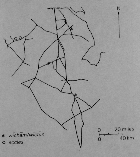
Kuurman studied the relationship between the -inga- place-names and the early burial sites in the East Midlands as Dodgson had done for Kent (Kuurman, 1975, 11-44). His conclusions were similar. The relationship between them was rare and the place-names seem to represent the colonisation phase as they had in Kent. For the East Midlands area, the element -ham also seems to be very important and Kuurman has stated that the -ingaham place-names were concentrated along the Roman roads just as Gelling had found for the wicham place-name (Gelling, 1967b, 87-104; Kuurman, 1975, 11-44). This would argue that -ingaham is early in date and has been reinforced by Cox's findings. His findings show that in the East Midlands, the -ham element is found near Romano-British sites and communication lines.
PERCENTAGES
When examining the relationship between the Anglian place-name elements (taken from Copley, 1988) and the early Anglo-Saxon burial sites in the Gazetteer, we see an interesting association between them. The total number of sites in the Gazetteer is 306 and the total number of place-names identified with those sites is 145 which equals 47.39%. The number of sites from the fifth and sixth centuries is 108 and the number of place-names identified with these sites is 66 which equals 61.11%. The number of sites from the sixth to seventh centuries is 145 with 97 place-names related which is equal to 66.90%. The number of sites from the seventh century is 31 with 32 place-name elements identified which equals 103.23%. If we look at the tables of these percentages (pages 96-100), we can see that -tun is the most numerous throughout the entire region with a total of 30 and -ing, byrh-stall, -clif, -brycg and -hyll are the least with no sites associated with that element. This pattern is similar to that found by Copley in the Southeast of England (Copley, 1986). These finds can mean that the -tun element is an earlier form that was first realized by place-name scholars or that the previous place-name was changed to -tun. This change would then alter the place-name pattern established by scholars. The evidence suggests that the -tun element is from the period of earliest settlement and continued to be used for several centuries after the initial settlement phase. The evidence from Copley seems to support this (Copley, 1986, 5-6). Cox has argued that the -tun element comes from the period after c.730 (Cox, 1976, 63). The problem with this argument is that he is basing his argument on the written sources which did not come into effect until around c.730. The -tun element may have been used well before this time. The evidence from the percentages is by no means absolute though. I realize that the evidence put forward is based on a survey of a survey and is missing some place-names and is therefore dubious in nature but this is the first true attempt to make a comparison of sites broken down into their individual centuries with the place-name elements from that site. Hopefully, this brief comparison will lead some place-name scholars within the region to examine the sites and place-names in this fashion. By doing so, a pattern which is different than now known may emerge.
Figure 5 Distribution of Eccles and Wicham from P. Stafford, 1985.
To see the percentages found in the East Midlands press 
CONCLUSION
Place-name patterns are often difficult to understand since place-names were constantly changing until the use of written documents. Some places are mentioned in early documents such as Bede but changed their names between 700 and 1086 and places may have been known by two or more names during that period (possibly because of a different dialect). This makes it very difficult to examine the place-name evidence. Because of this, it is very difficult to understand how place-name scholars can date a place-name and state that one element is older than another since so many changes were occurring to the languages and cultures during this period. Also, place-name scholars base their information on the documentary evidence which only began recording the names in the 700s. What about before this period? The place-names mentioned in the documents were the names they were known by at that time but the name may have been changed the previous year from another name. To say one element is older than another is dangerous since we have no evidence before c.700. A more detailed examination of the archaeological sites and their associated place-names must be done to fully understand the distribution and pattern of the place-names and their possible dates.
To Go Back to Chapter 2 press 
To Continue to Chapter 4 press 
Copyright 2005 tst4eco.geo@yahoo.com