Press any of the buttons below to go to my other pages.


You are currently on a

page.
Disclaimer: these pages reflect my own personal opinions and do not necessarily reflect Department of Conservation policy or opinions

Office days 
So far, all I've told you about are the outdoor jaunts in my job, it isn't like that every day though. I spend about half my time in the office sitting behind a computer.
Currently, I'm concentrating on puzzling out the vegetation monitoring history in Mt Egmont National Park. Don't get confused here, Mt Taranaki (mentioned earlier) and Mt Egmont are one and the same. About 20 years ago the long Maori history of the mountain was acknowledged and the name Taranaki accepted as valid. Taranaki means "barren mountain". Captain James Cook bestowed the name Egmont, after the Second Earl of Egmont, a former first lord of the Admiralty, when he sighted the mountain in January 1770.

Mt Egmont National Park is the second oldest National Park in New Zealand. It was established in 1900 and is 33,543 ha in size. It is almost a perfect circle, encompassing one of the most symmetrical volcanic cones in the world, right down to the edge of the ring plain. The mountain itself is 2518 metres high and last erupted in 1755. It is eroding every year and especially this year since it already has had twice the average rainfall for the year. Average rainfall is 8 m per year. Eventually it will wear down to bare bed rock, like the Pouakai and Kaitake ranges have done, seen to the right of Taranaki in the shot below.

 This soil composition picture gives you some idea of the relative positioning of the three volcanoes. Kaitake is the oldest, Pouakai next and Taranaki the youngest. The line of volcanoes is gradually moving South with Pouakai in between Kaitake and Taranaki. This soil composition picture gives you some idea of the relative positioning of the three volcanoes. Kaitake is the oldest, Pouakai next and Taranaki the youngest. The line of volcanoes is gradually moving South with Pouakai in between Kaitake and Taranaki.
The DoC page tells us; "[Mt Egmont National Park] Established, with the support of the Taranaki community, in recognition of the significance of the mountain to the surrounding land. A compact park centered around the volcanic cone of Mount Taranaki/Egmont, with more than 320km of walks and tracks, allowing visitors to view sub-alpine forest, volcanic landforms, mountain streams and waterfalls, and alpine herbfields." Have a look at this map of New Zealand to see where the various parks are. |
The largest town in the Taranaki region is New Plymouth, sharing the coast with its mammoth co-tenant Mount Egmont. New Plymouth has some of the most beautiful parks, lakes, ferneries, fountains and waterfalls ever seen which is why it is probably the most photographed city in the country.
Anyway, back to what I get up to. The park has had a long history of goat and possum control, and as part of that scientists and foresters wanted some idea of the impact that these animals were having on the vegetation in the park. They did this in various ways:
I'm wading through boxes of data starting with four exclosure plots put on the mountain in 1968. Part of the problem is that some of the data has been lost over time (including one box that was accidentally burned by a conscientious cleaner) and that the vegetation and mountain have changed in the intervening years. This means that some of the plots are hard to find, and that we can't compare all the plots for all the years they were surveyed. I'm currently cataloging what data we do have.
This isn't actually as boring as it sounds because there are some real gems in the plot descriptions.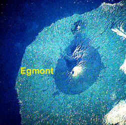 The mountain and park are surrounded by the fertile farmlands of Taranaki district, making the park look almost artificial, a vegetative pimple on rolling farmland. It was a Chinese man, Chew Chong who created the basis for a successful farming industry here. He built a butter factory, exported New Zealand butter to England and introduced shared milking which revolutionized the industry. Today, Taranaki district is the largest exporter of cheese in the world.
![]() ĀExclosure plots: Fence off small plots of vegetation, generally about 20 m by 20 m, to keep out goats (and sometimes the arboreal possum) and compare it to an adjacent unfenced piece of forest. The idea is to remeasure the plots every 5 years or so and thus pick up any changes in the forest due to possum or goat browse.
ĀExclosure plots: Fence off small plots of vegetation, generally about 20 m by 20 m, to keep out goats (and sometimes the arboreal possum) and compare it to an adjacent unfenced piece of forest. The idea is to remeasure the plots every 5 years or so and thus pick up any changes in the forest due to possum or goat browse.
![]() ĀVegetation lines: Randomly position straight lines on a map of the park and then physically traverse these lines in the field using fixed compass bearings and landmarks to guide you. At certain intervals describe the vegetation, use by animals (such as possum and goat browse) and any other notable features, such as dying trees, lack of regeneration etc.
ĀVegetation lines: Randomly position straight lines on a map of the park and then physically traverse these lines in the field using fixed compass bearings and landmarks to guide you. At certain intervals describe the vegetation, use by animals (such as possum and goat browse) and any other notable features, such as dying trees, lack of regeneration etc.
![]() ĀFaecal pellet lines: Somewhat similar to the above, except that you also note how many goat and possum droppings you find on the ground.
ĀFaecal pellet lines: Somewhat similar to the above, except that you also note how many goat and possum droppings you find on the ground.
![]() ĀPhotopoints: Taking shots of vegetation at intervals of one or more years. The photos are from fixed points looking in a particular direction so that hopefully you can see the changes over time.
ĀPhotopoints: Taking shots of vegetation at intervals of one or more years. The photos are from fixed points looking in a particular direction so that hopefully you can see the changes over time.

Permolat [sections of horizontal blind] is on a kamahi, Weimannia racemosa. Follow bearing of 320║ for 60 m, direction goes over windfall and through supplejack, Ripogonum scandens. Whole area is infested with supplejack and the wetter parts are choked with kiekie, Freycineta banksii. - Supplejack is vine that can grow really thick and tangled (imagine Tarzan like stuff, only denser thickets). The fact that it is mentioned in the description means that you probably spend half an hour getting tangled up in the stuff and climbing over fallen trees to cover all of 60 metres. Then you end up in a boggy part with still more supplejack and another scrambling vine-like species, kiekie, and this is where you have to measure trees and plants.
Travel on Mt Taranaki is not easy:
And: Plot lies between two small streams both of which are in steep sided (6 m deep) gullies. This what was reported in 1977. Due to the rapid erosion of the scoria cone these small streams are no doubt even deeper these days then back then. Or another example: From markers on river edge take a bearing of 250║ magnetic and note a large rimu (Dacrydium cupressinum) on the cliff top. Climb cliff by any way practicable and proceed back to above rimu. I hope to be able to find some of these plots over the next few years. It is not going to be an easy task because most of the plots haven't been surveyed since 1979 and lots has changed on the mountain since then.
As this description of the position of an exclosure plot shows: The terrain isn't the only problem:
Access is difficult too, and the exclosure plots were not serviced as often as needed.
1973 -The fence consists of four rows of 12 gauge high tensile wire covered with 3Æ6" high 2" chain mesh. Trees and 8Æ tantalized posts are used for posts. Forty battens have been attached at 3Æ intervals. Further battens are required to complete the plot (approx. 40). 1974 - Construction not yet completed. Approximately 40 battens are required and steel pins to hold the chain mesh to the ground. This material will be flown in with the 1974/75 supply drop.
No vegetation sampling plots have been established yet inside or outside the exclosure. Deferred until November 1973.
No vegetation sampling plots have been established yet. This will be done in conjunction with the completion of the plot.
I'm not sure that the plot ever was finished completely because nothing much happened to the exclosures from 1974 to 1986, and I have no descriptions of the plot in 1986. Still more boxes to root through though, so I might find the answer yet.
Some of the descriptions document the destruction of the forest by possums, goats or stock (effective fencing on the large boundary with surrounding farms took a while): Or: Scientific wording abounds: I enjoy compiling this sort of information into one document so that I and others can get a better overview of what has happened up on that amazing mountain, Taranaki. Hope that you enjoyed it too.
Some of my informtation sources or more detailed information can be found on the following pages.![]() More detail on volcanoes in New Zealand
More detail on volcanoes in New Zealand
![]() ĀAbout the volcanic makeup of the mountain.
ĀAbout the volcanic makeup of the mountain.
![]() ĀBrief description of tracks in parks around NZ.
ĀBrief description of tracks in parks around NZ.
![]() ĀThis site is an entry into tramping around NZ National Parks.
ĀThis site is an entry into tramping around NZ National Parks.
![]() Look here for a New Zealand map showing locations of National Parks.
Look here for a New Zealand map showing locations of National Parks.
![]() More information about the National Parks.
More information about the National Parks.
![]() Tourism Information about Taranaki plus a location map.
Tourism Information about Taranaki plus a location map.
![]() More tourist info and an aerial picture of Taranaki.
More tourist info and an aerial picture of Taranaki.
![]() Climbing Mt Taranaki
Climbing Mt Taranaki
![]()
Back to the diary index | More about me | More about my PhD | Other adventures
Next page
![]() Get your own Free Home Page
Get your own Free Home Page