Tops to Myall Great Walk
Location and brief overview
This potentially great walk begins at Barrington Tops Guest House and continues over Barrington Tops, Gloucestor Tops, The Glen Reserve, Wik Wauk State Forest and onto Myall Lakes passing a few kilometres from Bulladelah. It appears to be largely neglected for walkers in favour on council spending on coastal development for the non walker type tourism. It is my opinion that the walk needs to cease being promoted as a great walk unless significant spending is undertaken to pursue the original dream and passion of Dr Hans Pacey who insituted this so called great walk. Two of us - Dr Frank Bowling and myself underook the walk to Korseman's landing and decided to finish there after hearing that the majority of the boardwalk from Tamboy Village had been closed and that Mungo Brush had had trees removed after a fatality. I admit that we responded to the apparent knowledge of locals rather than investigating these sites for ourselves. After an email from another local we have come to realise that we missed out on some great spots by listening to the wrong advice. The much neglected Tressle Bridge site and the associated boardwalks, stairs, bridges and track is in desperate need for maintenance.
Our Experience
Day 1
A nine hour drive from Brisbane to Forster was undertaken in the hope to meet up with a friend of mine Richard Erlandson to arrange transport for our walk, i.e. leave our car at Hawks Nest. This was not to be and we set up camp south of Forster behind a transformer.
Day 2
We had to get to Dungog by 11 am as the guesthouse had offered a lift to them. So after a nice fatty breakfast we set off for Gloucestor, then Stroud and somehow to Dungog. It wasn't long before Frank who appears to mix up his names of places regularly was calling it Dugong. A bloke who wanted us to call him Harry whose real name wasn't Harry gave us a lift up to the guesthouse in an old and dusty 4WD. During this ride we came to the realise that this was no "O Reillies" type guesthouse but we only paid $100 for a room each and were offered 3 meals for this price. In retrospect we would have preferred to pay more to get more. But it was good value for the price. I went to the bar later that night to get a nice red wine for each of us. There are some nice walks along the Williams River from the guesthouse and fireflies for evening amusement.
Day 3 Barrington Guest House - Wombat Ck (16km)
About 1 am I got up and found "Rocky" the big grey kangaroo in the bathroom. His big body took up most of the floor. Afterwards (9:30 am) the guesthouse staff gave us a lift up to the Lagoon Pinch Car Park - at just under 500 m we needed to ascend over 1000m to reach Carey's Peak. The track went straight uphill. It wasn't long before we entered Antarctic Beech Forest and were impressed as these forests here are still expanding whereas further north they appear to be in decline due to the lack of sexual reproduction.
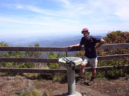
At the Corker the promised views failed to materialise or they were too insignificant to be impressed. Above the Corker, the forest changed to a sub alpine woodland and after lunch it wasn't long to a junction. Putting our packs down we climbed up to Carey's peak which has a marvelous lookout. Great views along the rest of the walk are possible if you can take the effort to get to them. After Carey's peak we made our way to Wombat Ck with a lovely camp site that was large enough to accomodate the 10 other tents up there at a decent distance from ours.
Day 4 Wombat Ck - Munro Hut (21 km)
Wombat Ck campsite has a pit toilet - the only sophisticated toilet until Korseman's landing. A great walk through four significant ecosystems - the sub-alpine woodland, the cool temperate rainforest dominated by antarctic beech, some heathland locations and wet schlerophyll forest. A rough 4WD track marks the turnoff to Munro Hut a few hundred metres before the link track car park. The link track connects Barrington Tops with Gloucester Tops. Munro Hut has been well looked after by the Newcastle Bushwalking Club who have done a marvelous job that needs to be better respected by some who use it. A lovely Ck coming from Mt McKenzie is a great water supply. We didn't treat it nor the water at the Mountaineer or Wombat Ck and we never got gastro but that doesn't mean it shouldn't be treated.
Day 5 Munro Hut - The Mountaineer (26 km)
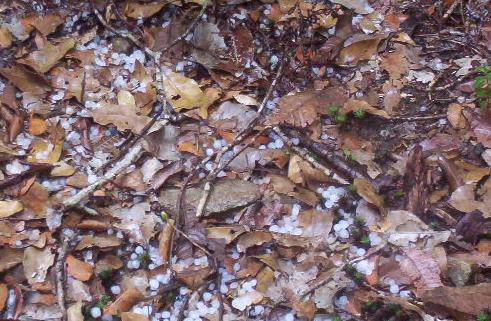
The distances provided are ours and not the bare minimum. We decided to see the Andrew Laurie Lookout and Gloucester falls and they were fantastic. It was too cold for a swim so we continued on our way. We had lunch at what we thought was Gloucester Gap but Gloucester Gap a little further on was an immense drop and altitude gain. This really was a hard day and the heat in the gap was enough to be mindful of in preventing heat exhaustion as the march back up is steep and continuous. After this, the "Pimple", "Pinnacle", and "the Mountaineer" seemed like immense hills. So it was with some satisfaction that we were able to find our camp site with a small shelter (God's providence) just before a hail storm struck with marble sized hail. A lovely Ck behind the camp provided our water.
Day 6 The Mountaineer - Log Dump (28 km)
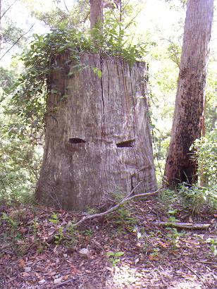
Getting up at this campsite is a delight. Frank and I even considered coming back here later to relax for a few days or use it as a base camp as it is an intersting location. Today was the first of the significant road walks where our walking track was to be shared with trail bikes. Fortunately we only came across 2 groups of trail bikes today coming from the "Frying Pan" camp site but they are so noisy that the peace can be destroyed for sometime. We had great views of the Karuah river that we reached for lunch before another hard uphill slog in the heat. Our fault for walking in summer but there were benefits such as a lighter pack without the winter sleeping bag and jumper. The steep track up past "Thuderbolts" ghost revealed very little left that is impressive about this icon. We found a new Thunderbolts ghost (pictured) which can be used for future reference near the little Myall river. At the Berrico road the going got easier because it is all downhill to the log dump campsite. A sign at the camp suggests water was 100 m away. The little creek 100m away had to be followed for another 500m until the Avon river was reached. For future reference if it is not recently very wet then go straight South west along a 4wD track and then follow the crest of the ridge down - the forest is open and easier than trying to fight your way down the creek.
Day 7 Log Dump - The Glen Reserve (28 km)
The Log Dump is a fairly poor campsite and not much different to camping on the side of any road as it is just a space on the side of the road. We were under the impression that hills wouldn't be a problem anymore but we were wrong. Before leaving the Avon State Forest we climbed up over Dean's Hill and then downhill into farmlands where we ate blackberries along the side of the road. On Bucket's way we arrived to see the XPT train go past and we collected a bottle of wine and some fruit cake that Frank had us hide here. The Glen Reserve provided a huge grassy campground amongst a forest from memory dominated by Flooded Gum. Water was in good supply and good condition but further from the campsite than it appeared and there were lots of Cissus vines in the area. The wine was a nice Shiraz.
Day 8 The Glen Reserve to Little Myall River (25 km)
A pleasant uphill walk along the Glen Road and then Bourke road passed the half way marker led to the beginning of the property marked "Alan Johnson's Sawmill". It was here we realised how little the entire walk is attempted as we had to fight through Lantana for about 1 km or more along what was left of this road until the junction with the Myall trail was reached. Being hot, this was hard work. If there is any part not to do in summer it is this as much of the treack was in the open and Euther represents a considerable climb. At a point just beyond the Chin-Doo-ee National Park Boundary is an old road with a sign to water. We couldn't find the water! After Euther is bypassed the track descends about 60 m before the Little River track is met and then a quick ascent leads to some lovely coastal views before dropping down steeply to the little Myall Valley. The camps described in the guide are overgrown or non-existant but about 1 km past the national; park boundary was a little turnoff across the creek with a nice shady clearing for our camp site.
Day 9 Little Myall River to Shorty's Camp (25 km)
This was a fabulously easy day in comparison to the rest. Walking past some cabins with some pretentiously peaceful name we reached Markwell Road and then Manning Road and ascended to find magnificant views to the North. At Andy's Shortcut the road descends steeply to Horse's Creek Road which must be followed for about 10 km. We were dissapointed with the state of the Trestle Bridge and the track described in the guide book which is terribly overgrown. Considering hte historical significance we thought it a great shame. Near the Wang Wauk Forest way I reccommend trying to follow the track to "The gorge" as there are still lovely sections of boardwalk here that nature hasn't fully reclaimed as yet. I picked up a few leaches here - one on my belly button.
A walk downhill lead's to Shorty's Camp which appeared to be vandalised by hoons who have used the camp ground as a rally car track. Water was of poorer quality here and definitely needed treatment if only to remove the stagnant taste from the rainforest pools with little flow rate.
A side trip I greatly reccommend as it gives the best views of the entire walk is uphill to the stony knob fire tower. Frank missed this unfortunately but it was only half an hour to walk to from the camp site.
Shorty's Camp to Korseman's Landing (25+km)
Frank and I made a mess of this one which can also be blamed on the lack of signage. Due to the new Pacific Highway put through recently, the signs are misleading when you come to it. We went under it much further South than we should have been and then never went north enough to get back on the crest of the Koolonock range. Instead we followed a road between the crest of the range and Alum mountain and then bush bashed uphill to the crest of the range before reaching Koolonock. The walk down to Korseman's landing was fairly straight forward. Avoid the fire trail once you are on the newly constructed track to Korseman's landing. Korseman's landing has bins and toilets but no fresh water so we asked for water from some kind campers and settled down for the night. This is a great spot.
Home Again
The decision was made that I would fetch the car and Frank would walk to Bombah point. By lunch time I was at Dungog and by 1 pm we were on our way back to Brisbane. A good walk but email me for more information at d.a.haliczer@stpeters.qld.edu.au if you are serious about doing the entire section we walked.
View from Carey's Peak
The road through the Glen Reserve
Rocky the roo with personal issues
Hail at the mountaineer
The new "Thunderbolts ghost"