The latest cartographical evidence available to us1 is Christopher Tolkiens map of The West of Middle-Earth at the End of the Third Age, so I took this as my basis. The main question was establishing a superposition between two features related in a significant way, one in Europe and the other in Middle-earth. Uncountable possibilities for such an equivalence existed: Minas Tirith and Rome, Lond Daer and Malta, Forochel and the Baltic, ... The ones finally chosen were Hobbiton and Sarehole. This seemed rather fitting to me, for in a way those were the places where it had all begun: Bilbos journey (which led to his possession of the One Ring and all the other world-shaking events) in the former, and Tolkiens life in England (with all the impressions that influenced his later descriptions of the Shire) in the latter. I therefore made these two points coincide, as theirs must be the surest identification in my opinion2. My latitude and longitude for Sarehole (and therefore Hobbiton) are the rounded co-ordinates for Birmingham: 52·5ºN, 2·0ºW.
The linear scale was already defined, and I took it to be constant all over the map. That, of course, if I were to draw the parallels, or lines of constant latitude, as horizontals (which I did), would make the meridians converge towards the top of the map. I considered only the meridian of Hobbiton to be vertical on the map (that is, coincident with the Northern direction as drawn in).
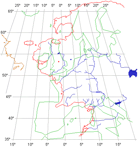
The result is shown in the accompanying diagram. It is, of course, only approximate at best, but even so several interesting correspondences arise:
The Anduin parallels the flow of the Rhine,
albeit in the opposite direction. The French Bay of Biscay coast corresponds
quite closely to the shoreline of Minhiriath and Enedwaith, between the
mouth of Baranduin and Drúwaith Iaur. The following further coincidences
are worth mentioning:
|
Rivers:
|
|
|
|
|
|
|
|
|
|
|
|
|
|
|
|
Mountains / Ranges:
|
|
|
|
|
|
|
|
|
|
|
|
|
|
|
|
|
|
|
|
|
|
|
|
Forests:
|
|
|
|
Other Areas:
|
|
|
As some kind of confirming evidence, I may yet mention the following. The choice of latitude at least was a good one, for in Unfinished Tales (The Disaster of the Gladden Fields) we read that: At the date of the disaster, in the latitude of Imladris ... there were at least eleven hours of daylight ... at midwinter less than eight. This agrees quite well with the times arrived at by taking the latitude of Rivendell to be 52·5ºN: about 11·5 hours of daylight in early Narbeleth (Kings Reckoning: late September), and about 7·5 hours of daylight around the New Year (Kings Reckoning: late December).
The matter is not closed, and discussion
thereon may and certainly will arise. I believe, though, to have contributed
somewhat towards the solution of what has always appeared to me a most
baffling problem.
|
|
For slightly different views, try the pages
by Alberto
Monteiro or Lalaith