© Ronald
Kyrmse
certur @ amonhen . com . br
THE GEOGRAPHICAL RELATION BETWEEN BELERIAND
AND ERIADOR
Certur Harmatir (Ronald Kyrmse)
Published in Mallorn,
the Journal of the Tolkien Society, No. 26 (September 1989)
In what follows I shall try to achieve
a concordance between two regions: Beleriand and adjacent lands on one
hand, and the north-west of Middle-earth after the drowning of Beleriand
(mainly Eriador) on the other. My main sources of cartographic information
are two maps:
A. the second Silmarillion map
in Appendix III to LR;
B. the map of the west of Middle-earth
at the end of the Third Age in UT.
Map B agrees well with that in LotR
as to scale; both are consistent with A, the only Silmarillion
map with a useful scale indication (the 50-mile squares). The same
squares, although without any clue about scale, are also present and in
good agreement on the first Silmarillion map in SoMe, as well
as the latters west- and eastward extensions.
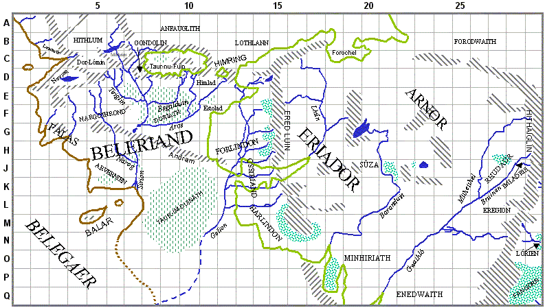
The proposed concordance between maps A
and B is possible because of certain geographical features that
appear on both:
-
the Hill of Himling (Himring), corresponding
to the island of the same name in B;
-
the chain of the Ered Luin with the outstanding
feature of Mount Dolm (Dolmed), corresponding to an unnamed spur just north
of an extensive wooded area in Forlindon.
The following passages from TB chapter
14 Of Beleriand and Its Realms give indications of distances, all consistent
with A. Quotations in {} brackets are from the Quenta Silmarillion
in LR chapter 9 with the same name as above. A land league, let
it be remembered, equals 3 statute miles, or 5,280 feet.
{... the Iron Mountains bent back northward
and there was a hundred leagues between them and the frozen straits at
Helkaraksë.} [Not in TS]
... Dorthonion {...} stretched for sixty
{a hundred} leagues from west {West} to east {East} ...
... the {this} mighty river Sirion ...
plunged through the pass ... flowed {down} south for [a comma instead of
for
in LR] one hundred and thirty {one hundred and twenty-one} leagues
... until ... he reached his ... delta in the Bay of Balar.
{... West Beleriand, at its widest seventy
leagues from river to sea ...} [Not in TS]
... the River {river} Narog ... flowed
some eighty leagues ere he joined Sirion in {the} Nan-tathren ...
... East Beleriand, at its widest a hundred
leagues from Sirion to Gelion and the borders of Ossiriand ... [Same text
in LR]
... some twenty-five leagues {seventy miles}
east of the gorge of Nargothrond Sirion fell from the north {North} in
a mighty fall below the Meres {meres} ... and he issued again three leagues
southward ... through ... the Gates of Sirion.
From the meeting of his arms he flowed
south for forty leagues before he found his tributaries; {then joining
his two arms Gelion flowed until he found his tributaries some forty leagues
south of the meeting of his arms.} and before {Ere} he found the sea he
{Gelion} was twice as long as Sirion ...
The discrepancies in the width of Dorthonion
and of West Beleriand are discussed by Christopher Tolkien in LR,
where the earlier values are discounted as being simple errors. One possible
explanation for the puzzling figure of 70 leagues given for West Beleriand
from river to sea is that the river in question is Narog, not Sirion
through some oversight, no doubt. The distance from the coast near Mount
Taras to Narog just south of Ivrin is indeed some 200 miles.
The map I have constructed joining A
and B uses the same numbering and lettering convention as A,
extended south- and eastward. I have only sketched in some features appearing
on neither A nor B:
-
the lower course of Gelion, to account for
the statement that its total course was twice as long as that of Sirion;
I have taken this as an approximation, and have not made it quite as long
as it might be, in keeping with the course of what (judging from its eastern
tributaries) is clearly Gelion in Map V of The Ambarkanta in SoMe;
-
the coastline of Middle-earth south of the
Bay of Balar, according with the same Map V;
-
the southern end of Taur-im-Duinath, which
judging from the published maps seems to narrow down south of the Bay of
Balar;
-
the extension of the Ered Luin (submerged)
west and south of Eryn Vorn, continuing its eastward curve already evident
in B and even clearer in Map V.
I might of course have extended the map further
southward and eastward beyond Fangorn and the issuing thence of Onodló,
but I thought this would add little or nothing to our knowledge of the
lands in question. My main interest lies in the mid-longitudes of the combined
maps, where A and B are joined.
I find it not unfair to point out the disagreement
between these measurements and the distance indications in Stracheys Journeys
of Frodo. She shows an east-west distance of over 372 miles between
Hobbiton and Rivendell, which according to B should be about 440
miles. The north-south distance between Hobbiton and the outflow of Onodló
some 380 miles furthermore appears on her maps as 250 miles.
Thus, quite unaccountably in view of the cartographic evidence already
present in LotR, her scale seems to be compressed by factors of
about 85% in the east-west and 65% in the north-south directions.
Doubtless many refinements remain to be
added to the present work, such as adjustments to the spherical shape of
the earth and fixation of the latitudes if not longitudes involved.
A point may be made for putting Hobbiton and therefore Imladris as well
at about 50ºN, which agrees with the statement by J. R. R. Tolkien
in UT note 9 to The Disaster of the Gladden Fields:
At the date of the disaster [30 Yavannië,
or late September], in the latitude of Imladris ... there were at least
eleven hours of daylight in open country; but at midwinter less than eight.
Bibliography
The Lord of the Rings, George Allen
& Unwin, 1978; abbr. LotR
The Silmarillion, ed. Christopher
Tolkien, George Allen & Unwin, 1977; abbr. TS
Unfinished Tales, ed. Christopher
Tolkien, George Allen & Unwin, 1980; abbr. UT
The Shaping of Middle-earth, ed.
Christopher Tolkien, George Allen & Unwin, 1986; abbr. SoMe
The Lost Road, ed. Christopher
Tolkien, Unwin Hyman, 1987; abbr. LR
Journeys of Frodo, Unwin Paperbacks,
1981
HOME