![]()
![]()
![]()
![]()
![]()
![]()
The street pattern in Denver resembles that of many other midwestern cities: most of the major arterials are spaced at one-mile intervals, because they run along the section/range/township lines that were surveyed so many years ago. Broadway divides east and west addresses, and Ellsworth Avenue divides north from south. Neither of these streets run uninterrupted all the way through the city, but the zero axes on which they lie do. Likewise, the streetnames extending outward from these axes in each direction are carried through 5 of the 8 counties that comprise the greater Denver area. Thus, for people who invest a little time familiarizing themselves with the street rotation, this system makes it quite easy to instantly locate perhaps 9 out of any 10 addresses in Denver.
Incidentally, if you're interested in the history, pattern, and/or names of Denver streets, I recommend the book "Denver Streets" by Phil Goodstein (New Social Publications, Denver, 1994; I think it's out of print now). Some of the info below is from his research.
South of Ellsworth, from the 3.5 block (Nevada Place) to the 18.5 block (Utah Place), most east/west roads are named after states.
Beginning with the 67th block east of Broadway (Niagara Street), most north/south roads are named after cities and towns in the US. This continues until about the 183rd block (Yampa Street); east of there most roads are named after places in foreign countries.
Given that, you might be wondering the same thing I did: are there any places where a road named for a city intersects a road named for the state in which that city is located?
My initial thought was: yes, there should be several. After all, we're talking about at least 1500 intersections on the grid, and there could be even more with the theoretical Courts and Drives that would share the same name as their nearby Streets.
However, when I tried to locate such intersections on a map, I actually found very few. Only six, to be exact - you can view a map showing the locations here*. I'll discuss those first, and then share some thoughts on why there aren't more.
*Disclaimer: between I-225 (or Potomac, the 137th block east) and Tower Road (185th block east), there are several streets named for towns in Colorado. The 18th block south is Colorado Avenue, and it does intersect several of these north/south streets. I didn't include these intersections in my count.
Ohio did very well in my little survey. Below is a photo of the street signs posted where Ohio Avenue (the 8th block south) intersects Dayton Street (the 97th block east).

(All photos from late 2002/early 2003.) About a mile east of there, Ohio also intersects both Kenton Street (110th block east) and Lima Street (113th block east)...

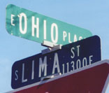
...although I should add that it's open for debate whether "Lima" refers to the city in Ohio or to the capital of Peru. It does fall in a slightly "abnormal" section that includes other foreign names - such as Florence, Geneva, Havana, Jamaica, Kingston, Paris, and Quari. Goodstein says it was named for both. Also, he's the one who claims Kenton is for the town in Ohio. I'm a little skeptical that we'd name a street for such a small and distant town, but I don't have any better suggestions. And there does seem to have been a fondness for locations in Ohio...
Anyway, below we have the 14.5 block south (Idaho Place) intersecting Lewiston Court, which is a neighbor to Lewiston Street (the 162nd block east).

The 10th block south (Tennessee Avenue) actually intersects two roads named for Memphis. Memphis Street is the 163rd block east...

...and just down the road there is also a Memphis Way.

If you're aware of any others, please let me know! Here are some observations on why there are so many fewer than what I would've expected:
Street pattern.
Most of these intersections occur in east Denver and Aurora - in other words,
outside the older, uniformly-gridded section of the city. For the most part,
this area has a distinctly suburban street pattern (i.e. lots of curvy and discontinuous
streets). Thus in several cases where there could be an intersection
(such as Akron/Ohio, Nome/Alaska, Tucson/Arizona, Norfolk/Virginia), one or
both of the roads don't happen to exist at that particular point on the grid.
Some of the state names are already used elsewhere.
Many of the north/south streets are named for places in the northeast: particularly
Pennsylvania, New York, and New Jersey. But Denver didn't name any east/west
roads for these states - probably because it would've caused confusion with
Pennsylvania Street (5th block east), York Street (23rd block east), and Jersey
Street (59th block east). Several others are named for places in California
- but there was already a California Street downtown. Other streets are named
for Indiana and Illinois cities. Goodstein reports that modern Center and Exposition
avenues (which seem odd in the middle of a section otherwise named for states)
used to be "Indiana" and "Illinois" avenues, respectively. But they were changed
in 1882 to honor the "National Mining and Industrial Exposition" (Center Avenue
dead-ended in the center of the fairgrounds). Today there's an Indiana Street
(148th block west), and an Illinois Street in Golden.
Other states weren't used as streetnames.
Some streets are named for places in Georgia, Massachusetts, Michigan, Missouri,
Nebraska*, Texas, and Wisconsin. The first two
states are not used as street names at all. Each of the other states are represented
on street signs somewhere in the metro area, but they are all isolated streets
which don't run throughout the city.
*Some maps indicate that Nebraska Way intersects Kearney Street. These maps are in error. Nebraska exists only between Forest Street and Honey Way. East of there it's only an alley with no street signs to its end at Krameria Street.
Several states have none of their cities represented.
(North and South) Dakota, Kentucky, Mississippi, Louisiana, Wyoming, Arkansas,
Florida, and (New) Mexico are states remembered on east/west avenues, but without
any north/south streets named for their cities.
A few final notes:
It's difficult to know for which city some of the streets are named. One
example is shown in the photo above: there are at least 15 towns in the US named
"Lewiston". Lewiston ID is one of the biggest, but perhaps they were thinking
of Lewiston ME, which is even larger. Also, does Salem Street recall the city
in Oregon or the one in Massachusetts? Goodstein says Mass. I assume Clinton
Street is for the city in Iowa - and Goodstein agrees - but who knows? Does
Carson Street refer to Carson City NV? Or Fort Carson CO? Goodstein claims it
was actually named for Carson CO (that is, the miniscule burg south of Lake
City - not the military base). But I find it hard to believe that a virtually
unknown locale would've been chosen instead of any of the more well-known "C"
towns in Colorado. What about Richfield Street? Does that mean Richfield UT?
Again Goodstein claims it's for the one in Colorado, but again I say: how many
people have ever heard of Richfield CO? And why would that have been selected
over so many more obvious choices?
![]()
![]()
![]()
![]()
Page created 20 January 2003; last updated 17 April 2006. |