Cumberland Mountain: This segment (formerly Section 1)
traverses the ridges of Cumberland Mountain from Cumberland Gap
to Cove Lake State Park. Currently the Eagle Bluff unit is open,
and extends 10 miles from Big Creek Gap near LaFollette, TN, to
Cove Lake State Park at Caryville.
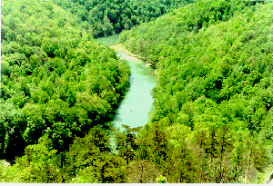
Length: 9.9 miles; rating: difficult. This segment of the
Cumberland Trail offers spectacular views of the Powell River
Valley to the south and the Cumberland Mountain range to the
north. It is recommended to hike this segment from north to
south because the first six miles are in rocky, rugged terrain.
Location: Northern trailhead is on Tennessee Avenue in Lafollette
(going north through Lafollette, turn left at the seventh traffic light.
Trailhead parking is on your left). Southern trailhead is in a neighborhood
north of the boundary of Cove Lake State Park in Caryville. Trail maps are
available from the Cumberland Trail Conference, Route 1, Box 219A,
Pikeville, TN 37367. Email: cumberlandtrail@rocketmail.com.
There is a developed spring at the Lafollette trailhead parking lot,
Tank Springs. Many local residents avail themselves of this delicious
water for home use. The trail starts on a dirt road following the
railroad grade along Big Creek, and makes a left turn to pass under the
railroad bridge. It then follows Ollis Creek for a short distance before
turning left and switchbacking up to the crest.
The first mile of the climb offers beautiful, fragrant rhododendron in mid
to late June. Once on the crest, the trail follows the ridgeline. At mile
1.8 is a rock outcropping where it appears that the trail comes to an end.
There is a magnificent scenic view at this point. The trail continues down
through a crevice in the rock outcropping. A spring is located at mile 1.9
and a primitive campsite at mile 2.1. After leaving the campsite the trail
follows a wet-weather stream with a vertical rock wall on the right. Be on
the lookout for Window Rock, an opening in this sheer rock wall on your right.
At mile 6 the trail comes out onto Old Kentucky Road, or Eagle Bluff Road as
the locals call it. Turn right on this dirt road and walk 0.3 miles to a
side trail on the left going up to Eagle Bluff Overlook. The trail turns
left off the road a short distance after the Eagle Bluff Overlook spur trail
and returns to the woods. Pay attention to the blazes for the first 1/2 mile
- there are many 4-wheel paths in this fairly level area. This is the site
of an old village that was located along the road in the 1800's.
The trail continues on the crest for another 1.5 miles and then turns left
to start the descent on the southern side of the mountain. This portion has
earned the name "Suck Air" if you happen to be travelling in the uphill
direction! A side trail off this descent leads to Devil's Racetrack scenic
view with fantastic rock spire formations. If you hike this trail in the
summer, you will be rewarded with blackberries on the Suck Air descent.
The trail comes out in a subdivision north of Cove Lake State Park.
Follow the gravel road down the mountain into the park.
Arleen Barnett
8/97
We Thank You For Your Efforts:
The Eagle Bluff unit of the Cumberland Mountain Segment has been
adopted and is maintained by Eagle Scout Troop 622 of LaFollette, TN.
Led by the efforts of Phil Car, Eagle Scout Master, the troop
is also exploring revitalization of an additional seven miles
from Woodson's Gap south to Big Creek Gap, a distance of 7 miles.

 RETURN TO MAIN PAGE
![]()