 |
| Home |Introduction | Books & Papers | Animations | Expansion Sites | Science Links | Download |
Transverse
Structures
Throughout the Tethyan orogenic belt there are major transverse faults, which appear to be essential complements to the Tethyan torsion. Such are the Biscay, Adriatic, Silesian, Tuz, Dead Sea, Oman line, Masirah, Ordnach-Nal-Mogur, Madras-Beijing, Ninety-East, New Zealand Alpine fault-all to be discussed below, and others.
A category of sinistral faults start as part of the Teihyan torsion, but are dragged sinistrally by the movement of Eurasia to trend north-westerly across the Tethyan belt. These faults, which include the Biscay, Adriatic, Silesian, Lut-Caspian, Masirah and Arach-Nal-Mogur faults They seem to have their maximum displacements within the Tethyan belt, but then terminate toward its boundary. A second category are dextral and cut the Tethyan torsion obtusely and in many cases offset it.
The westward drag of Europe by the Tethyan torsion caused the sinistral rotation of Spain (40o), of Corsica-Sardinia (60o), Sicily (35o) and Italy (l00o) against this fault, with the opening of the Ligurian and Tyrrhenian sphenochasms (Figure 36, p. 59). It is really one of the splays of the Tethyan torsion (Figure 37, p. 57), which shows stages in its development.
Parallel to and cognate with the Biscay fault is the northwest-trending Adriatic fault (Figure 37, p. 57) that begins in the strong bend of the western Alps, traverses the Po Valley, then down the Adriatic Sea and the coasts of Greece and Crete, and dies out in the Gulf of Suez and the Red Sea.
It is sinistrally transcurrent with a shift of about 1,000 km, which shifts the Dinarides from being a tandem continuation of the Apennines to an over- lapping duplication of them (Figure 37). The tensional end caused the grabens of the Aegean Sea and by the opening of the western Mediterranean between Crete and the Nile estuary. At the other end the shift is taken up partly in the nappe stack of the western Alps, and partly by westward shift of Europe relative to Africa.
The parallel Insubric fault from the central Alps, flanking on the northwest the Dinaric orogen to Greece, is a sibling of the Adriatic fault and shares the same movement.
Evolution of the Mediterranean.
The Mediterranean is dual. West of Malta, the Mediterranean is a grossly widened double orogen, with Africa on the south, overridden by its orogenic zone, and Europe on the north, overthrust by its orogenic zone (Figure ll, p. 39), and in between several widely opened sinistral sphenochasms. East of Malta, Africa fronts the new sea floor without a bordering orogenic zone. Europe is fronted by a double orogen, overthrust both north and south, and splayed into oroclines.
This fundamental duality divides the Swiss Alps from the Austrian Alps. Fifty years ago, my introduction to Alpine geology was Collet (1927), a Swiss, on the western Alps, and Heritsch (1929), an Austrian, on the eastern Alps. The two accounts were so different that the two halves of the Alps could have been on different planets.
At Villach, near the convergence of Italy, Slovenia, and Austria, the gross pattern of the Alps changes. Westward, is a normal northwest geosynclinal flank, progressing through the Jura folds, the pre-Alp klippen, the miogeosynclinal Calcareous Alps, then the reappearance of the geosynclinal floor (the massifs of St Gotthard and Aar, the Aiguiles Rouges and Mont Blanc, Belledonne, Pelvoux, Mercantour, and Maures), then the Pennine nappes and the root zone.
The corresponding section through the Eastern Alps starts with the Flysch zone, then the northern limestone zone extending from the Rhine to Vienna. This corresponds in age to the High Calcareous Alps on the other side of the Rhine, but is quite different in facies. Then follows Paleozoic schists and gneisses of the graywacke zone; then the core zone from the SiIvretta Alps to the Mur Alps; then the central gneisses and schists of the Hohe Tauern window.
Incompetent shale and flysch developed cleavage, while brittle feldspars and quartz shattered or show deformation lamellae. Phyllosilicates recrystallized. Calcite twinned intensively, and added new growth. The intensity of these phenomena peaked in the south about St Moritz waning altogether through the 1100 km north to Obersdorf. The "Adria" block, bounded by the Insubric line, has moved relative to the west during the Tethyan torsion.
Thus the western Alps and the eastern Alps are quitie distinct. The boundary between them is the Arasa suture zone, a melange which includes Ophiolite, pelagic sediment, and blocks of continental derivation. The tectonic kinematics are also distinct (Ririg et al., 1988; Platt et al., 1989; Ratschbacher et al., 1989). The tectonic fabric shows strong simple shear extension in directions from west to northwest (mean 285o).
The orogenic continuity between the Apennines and the Tunisian belt is briefly interrupted by the Maltese Miocene-Quaternary graben system (Dart et al., 1993), a mesh of many faults indicating some 40% elongation in a NW-SE direction.
This fault runs along the southwest side of the Silesian plain of Poland, flanking the East Carpiathians, cuts off the Dobrudgea from the Crimea, separates the Walachia and Black Sea mantle diapirs, and the spreading zone of the Aegean diapir (Fig.11 p. 39) from central Turkey. It has moved Cyprus 200 km from its Mesozoic position against the Gulf of Antalya (Fig. 8a, p.29). The Silesia fault anastomoses through Turkey, the eastern branch passes close to Ankara, cuts off the Pontides; moving them some 200 km south to continue as the Anatolides, shifts the Cretaceo-Tertiary Cankiri basin 200 km to become the Hyana-Tuzgolu basin and reaches the south coast near Adana, whence it continues, perhaps to join the Red Sea Rift.
A conspicuous linear runs from the Gulf of Guinea to the Mediterranean and Cyprus. The trend begins in the Atlantic with a submarine ridge and the diapiric volcanic islands of Annobon, Sao Tome, Principe, and Femando Poo, Continues into Africa with the Mt. Cameroon volcano, continues along the Nigerian border to pass south of the Lake Chad depression, along the Bahr el Ghazal to border on the south the Khoro Toro depression for 80 km, continues across the plain of the Libyan desert past the Kufry Oasis to border the Quattara depression for 80 km, then across the Mediterranean past Cyprus along the lower Asi River and the Golu depression. This may be a normal fault throwing down to the northeast, or it could be the southern limit of the Tethyan system, continuing the Tubuai shear of the Pacific (Figure 47, p. 69). It continues across Turkey as a sinistral shear, off-setting the Alpine front several hundred kilometers.
The Dead Sea rift is sinistral, but has a large angle to the Tethyan torsion and shows no evidence of having been rotated. Its shift is estimated at 100 km (by offset formations and by correlating the strata-bound copper deposits at Timna and a similar Jordan exposure on the eastern shore of the Dead Sea. The fault depression runs from the Red Sea, along the Gulf of Aqaba, the Wadi Araba and the Jordan valley including the Dead Sea and the Sea of Galilee. From the upper Jordan valley, the main fault follows the coast from west of Beirut until it meets the Cyprus front along the Gavur Range, but a branch bifurcates toward Lake Homs and rejoins the main fault along the Gavur Range.
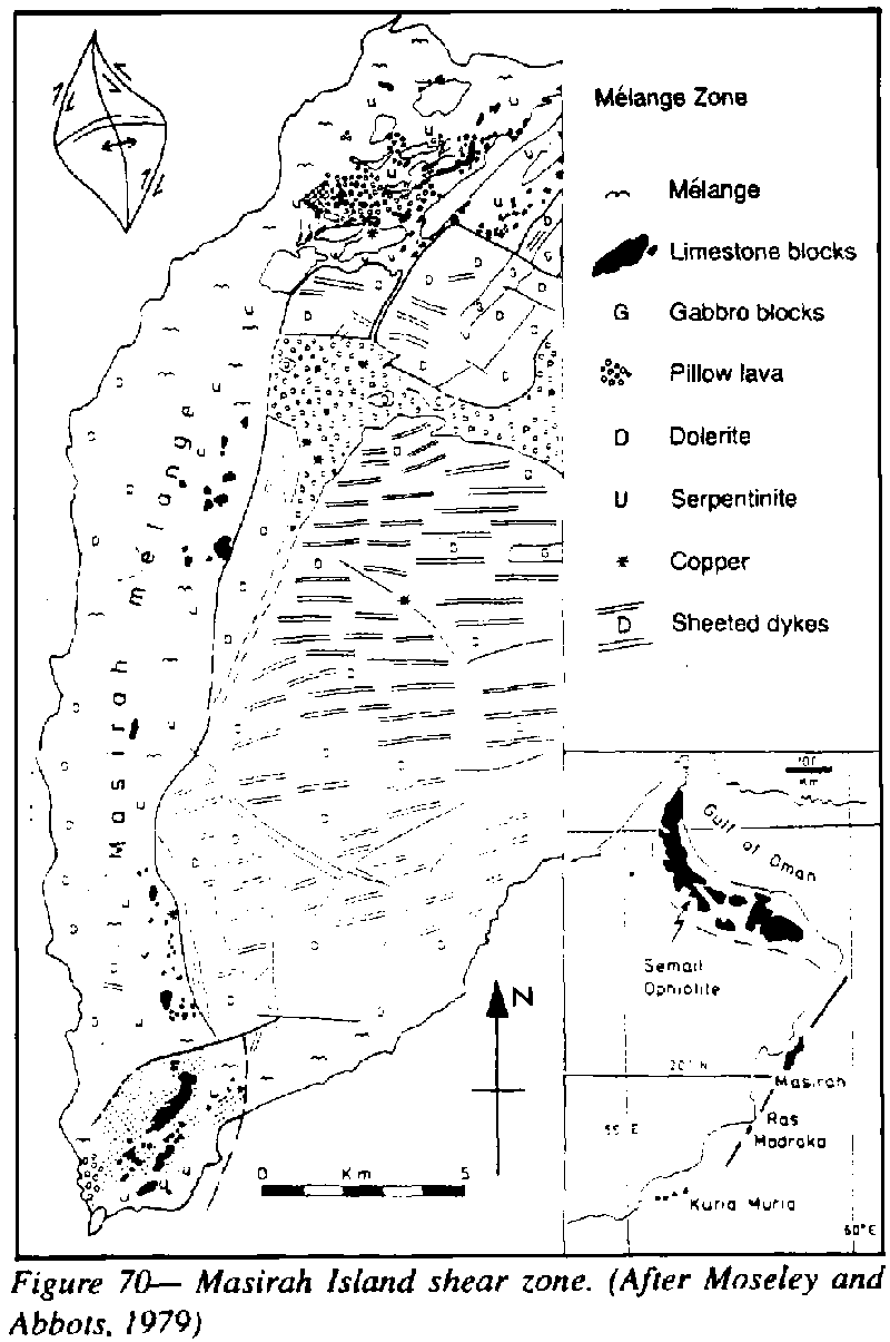
The Masirah Island fault terminates the Oman sphenochasm, cutting off the Oman ophiolite complex, cuts Masirah Island, and the ophiolite outcrops of Ras Madraka, and skirts the Kuria Maria Islands along the southeast side of the Arabian Peninsula, which it separates from the Somali Pehinsula. The Masirah fault along the southeast coast of Arabia began as the same fault as along the southwest coast of India, before the broad opening of the western Indian Ocean, just as the single Adriatic fault later opened to form the Adriatic graben. The Ovrven lineament is the current spreading zone.
|
The question arises whether the Masirah ophiolite is a continuation of the Oman belt offset 200 km by the Masirah dextral shear, or whether the ophiolite has intruded separately along the Masirah fault itself. This might be suggested by the continuation of the ophiolites along the Lut and Zagros lineaments. The fact that the Masirah sheeted dykes trend east-west indicates that they have been offset from the Semail after the ophiolite body had consolidated. Masirah is a dextral megashear of large shift, with major transverse extension associated with the initial opening of the Indian Ocean. The 5-km melange zone along the western side of Mesirah has already been described. (p. 33).
Photo-interpretation by Moseley and Abbots suggest a 5 km wide faulted ophiolite zone across the middle of Hallaniya, the largest of the Kuria Maria Islands.
The so-called
mid-ocean ridges have been misnamed.
They are really circum-continental ridges, recording the peripheral growth
of each continent. The
error is fundamental, and arises from the misinterpretation of orogenic
belts as compressional, instead of as diapirically tensional, as explained
in Chapter 5. The difference between a mid-oceanic spreading rift and a
mid continental spreading rift, is that the former remains empty, or bulges
as an oceanic rise, whereas the latter is fed with sediment, which is later
regurgitated as nappes. When these entrenched misunderstandings are removed,
the whole Earth becomes a mosaic of continental nuclei, each surrounded
by its spreading zone (Figure 93, p. 114).
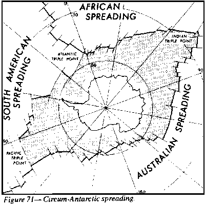 |
Transverse to the Tethyan Torsion are the primary ocean rifts-Pacific, Indian, and Atlantic-that started to open at the end of the Triassic, but developed most rapidly since the Early Cretaceous. They commence from near the north pole of the time trending meridionally. If they were symmetrical they would attain their maximum opening at the Mesozoic equator, and converge again toward the south pole. But they are far from symmetrical. Southward, they continue to widen until they reach the large stable polygon-Antarctica, surrounded by the circum-Antarctica spreading rift (Figure 71)
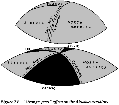
Forty years ago, when I first announced the orocline concept, one of the examples I gave was the Alaskan orocline (Figure 72). The Arctic and Atlantic Oceans were depicted as a sphenochasm gape originating from the Alaskan orocline.
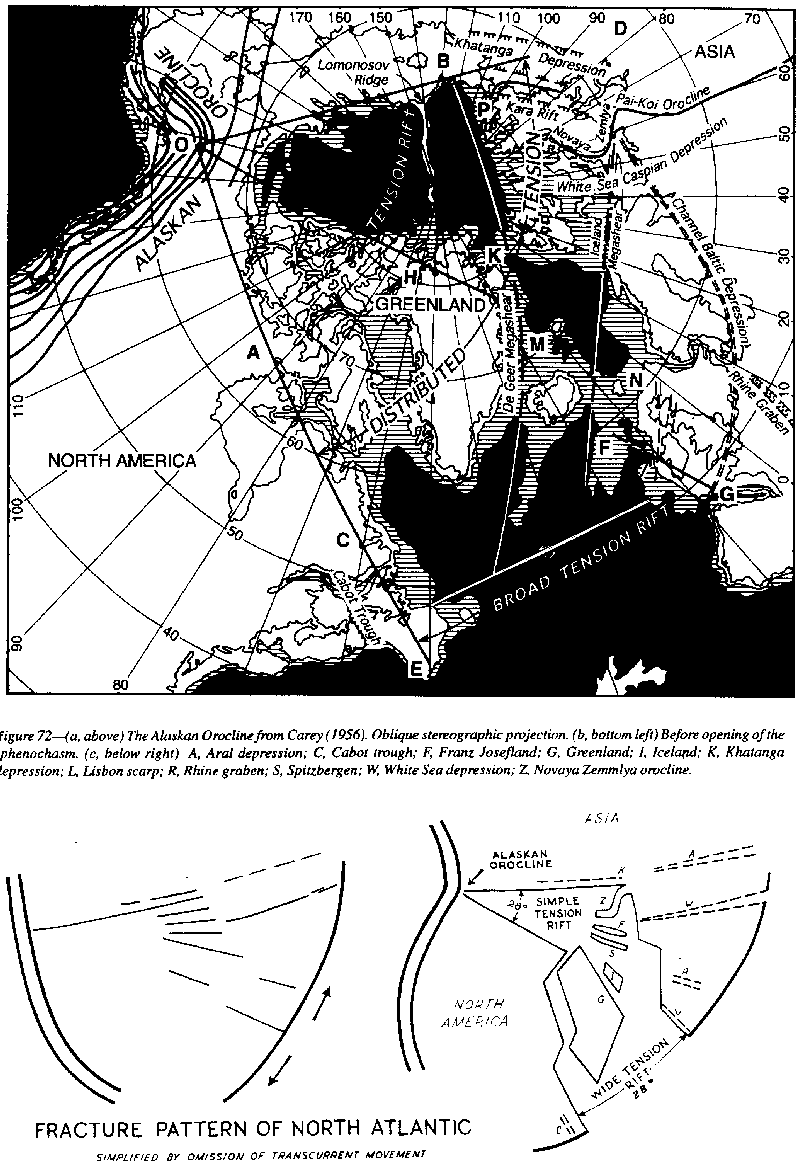 |
The late Professor Runcorn sent one of his graduates (D.B. Stone) to Alaska to check it out paleomagnetically. But, instead of clockwise rotation of the Alaska Range with respect to continental North America, he found counter clockwise rotation (Packer and Stone, 1972), the opposite to what had been expected from the opening of the Arctic!
 |
 |
Compare the Alaskan sphenochasm of Figure 73 with the Pacific sphenochasm (Alaskan sphenochasm) of Figure 74. The Pacific sphenochasm is complicated by the Sinian Torsion of Figure 63 p. 79). These two motions go far towards, explaining the opening of the Pacific. But the Pacific is older than the Atlantic. The latter is post-Cretaceous whereas the sphenochasm between the Emperor-Hawiian ridge and the Kurile-Japan line is largely pre-Cretaceous (see the discussion headed "Missing Cratons" on p. 118).
Another fundamental
line starts from this center, the Mackenzie-Missouri line, which divides
the North American continent into two contrasted topographic provinces.
This line runs along the Alaskan North Slope, the Mackenzie valley for
a thousand km, south of Great Bear Lake, Great Slave Lake, and Lake Winnipeg,
down the Missouri valley to Kansas, thence, to the Florida Shelf. Northeast
of this tine, from Elliesmere Island to Labrador is the lake country, low
craton with hundreds of lakes. Southwest of it is younger more mountainous
country.
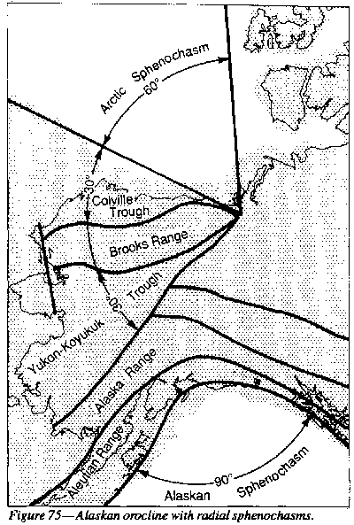 |
The Brooks range is more than 200 km wide, and its diapiric core, more than 50 km wide, has risen more than 50 km, with cross-section area more than 2,500 km2 If this extruded as a single sheet 1 km thick (the average nappes are less than this) it would flow out 2,500 km! But before it had gone a fraction of this distance, friction on the base would halt the front, so the sheet would break off and thrust over or under the first part, and continue thus to stack up a pile of nappes, with an additive overthrust which could total 2,500 km.
The Brooks Range orogen is a Carboniferous to early Cretaceous eugeosyncline which regurgitated in the Early Cretaceous. The Misheguk Mountain nappe came up from the floor of the eugeosyncline consisting of serpentinite, peridotite, and gabbro and other ophiolitic rocks, with well foliated metabasites, metapelites and marble.
Jurassic paleomagnetic dates from some of these rocks seem to have been tectonically reset. Marked variation between the rocks of single epochs indicates general instability. The Mississippian strata include much black chert with carbonates and some dolerite sills. Pillow basalts occur in the Triassic with radiolarian chert, which indicates the beginning of the deep rift that accompanied the opening of the Arctic. Olistoliths in flyschoid strata occur in the early Cretaceous.
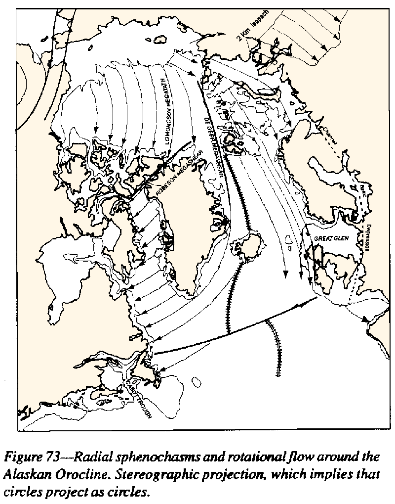
The pattern of the Alaskan radial sphenochasms is simply a case of Van Hilton's "orange-peel" effect which is inevitable on an expanding globe (Figure 74). This kind of relationship is only possible on an expanding Earth.
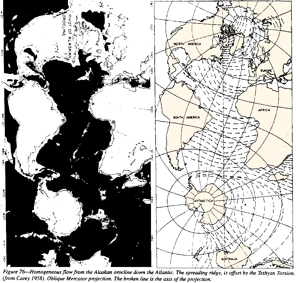
The opening
of the Alaskan sphenochasm may be extended throughout the full length of
the Atlantic (Figure 73). The diagram shows the consistency of expansion
pattern. The axis of spreading has been offset nearly 3,000 km by the Tethyan
torsion. The amount of spreading increases from the Arctic to the south
Atlantic. The opening of the Arctic increases from zero to 1,500 km. At
Ireland the opening has doubled to 3,000 km. From Brazil into the Gulf
of Guinea, it is 5,000 km. At the southern tip of Africa it has increased
to 6,500 km. The opening ends on the peri-Antarctic rift.
 |
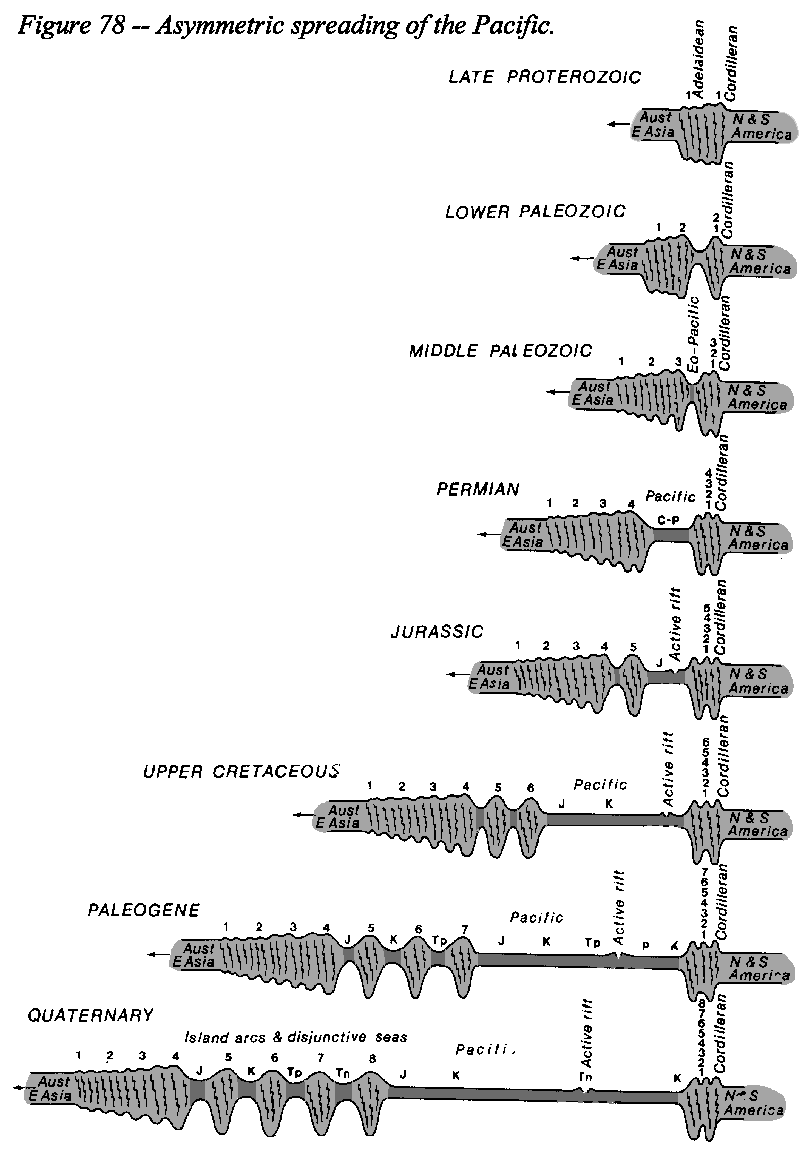
The initial opening of the Pacific came only in the early Triassic, contemporaneous with the shift of the equator from the Caledonian-Appalachian-Tasmanide position to the Tethyan position. The Jurassic Pacific attained a maximum width of some 5,000 km (Figure 47. p. 69). The mid-oceanic spreading ridge was probably along the Shatsky rise, and the Marshall Islands rise. South of the Tethyan Torsion the data are more vague. The Emperor ridge, the Hawiian ridge and the Line Islands rise seem to be correlated offsets. Alaska and Canada supplied sediment to the Japanese geosyncline, Mexico supplied sediment to Fiji, and outlying parts of the Australian craton supplied sediment to the Andean region (see pp.1 I 2- 123).
 |
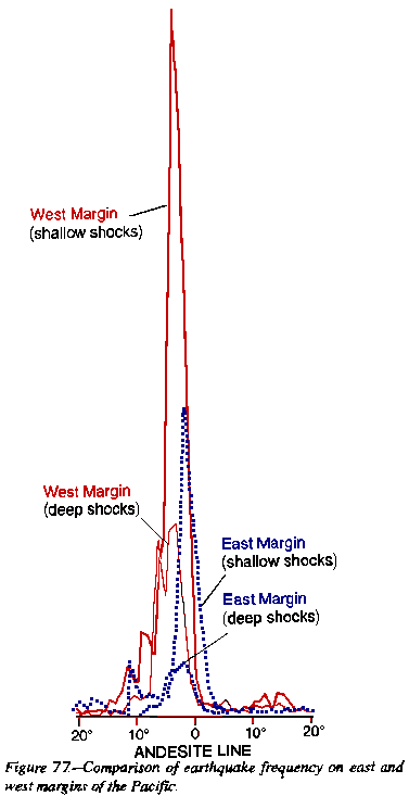 |
Tectonic activity has been much greater along the west margin than the east margin of the Pacific, which is illustrated by Figure 76, which shows the frequency of earthquakes within 20o of the margin. Volcanism is also much more intense along the western margin. The spreading of the Pacific Ocean has been asymmetric-greater spreading southward in the southern hemisphere, and greater spreading eastward along the western margin than western from the Americas. Tertiary disjunctive seas have opened all the way from the Aleutians to Antarctica, but on the American side there are none (Figure 77).
 |
The western lune is bounded on the west by a sinistral megashear which extends from Cape Hora via the east coast of Africa to Baluchistan (Figures 76 and 77) and continues via the western syntaxis of the Himalayas, thence across Asia to Alaska. The Owen Ornach-Nal-Mogur lineament shifts the front of the Oman Mountains 1,800 km sinistrally to the Himalayan boundary-fault (Figure 40, p. 61) the western syntaxis of the Himalayas.
 |
West of the shear zone are a series of deep tensional "holes" - the Oman Sea, Jaz Murian, Dasht-e-Bado, Sisian, and the Helmand depressions. They are of course diapirs, because in each case the mantle has risen to within a few kilometers of sea level from being tens of kilometers lower. Some of these depressions remain empty, others accumulated thick sediment, while others have extensive volcanism. Andesitic volcanic rocks occur along the Chagai Hills and Ras Koh, some 400 km north of the Makram coast, and particularly through the Kavir sphenochasm, and the northern half of the Lut diapir.
The trends of the Himalayan folds through Ladakh and Afghanistan are splayed like outstretched fingers: the Karakoram, Pamirs, and Hindu Kush. On [in] the southwest of the zone, the spreading is even greater from the Makran trends of Baluchistan to beyond the Hindu Kush to the Tien Shan. Southward, this zone is the line of opening of the Indian Ocean.
North-eastward from Kara Kum to the Siberian plateau, the Owen-Pamir linear divides the central Asian highlands from the Siberian plains, extending along the Lena valley and thence to the Paleogene pale in Alaska. This is one of the major lineaments of the Earth. On the southeast side of the lune, a dextral megashear extends from the South Shetlands and South Orkneys via the Prince Edward Island ridge to the Nepal syntaxis of the Himalayas, thence continues through East Asia via the Ordos megashear to Alaska. Both boundaries have meridional steps. Within the lune between these megashears, the Scotia arc is dragged eastward more than 2,000 km. The Agulhas Plateau, Mozambique Plateau, Madagascar, Seychelles Ridge and India are each separated by meridional rhombochasms (with their acute angle at the north and south) implying a total extension between these megashears of about 20,000 km.
The middle lune is bounded on the southeast by a dextral megashear which commences near the contemporary pole, flanks the Scotia arc, cuts off the Kerguelen plateau, passes through the inflection of the southern spreading ridge, terminates the Ninetyeast Ridge, cuts off the Broken Ridge and the outlying fragments of the Australian craton (including the Naturaliste, Wallaby, and Exmouth Plateaus), flanks the Australian craton and the Arafura Sea as the Geelvinck Fault of Figure 46a (p. 68), thence to the junction of the Emperor and Hawaiian Ridges, thence to the Gulf of Alaska and the contemporary pole. Throughout its length, this lune is dominated by quadrate rhombochasms with acute angle at the northern and southern corners and obtuse angles at the east and west, dextral shears along their northwest and southeast sides and tensional faults along their southwest and northeast sides.
The eastern lune is bounded by the lineament of the New Zealand Alpine Fault, which also commences near the contemporary pole, crosses Antarctica near the present pole, flanks the Macquarie Ridge, passes through New Zealand, along the Kermadec-Tonga Trench, terminates the Samoa Ridge, cuts off the Hawaii Ridge, thence continues to the Gulf of Alaska and the contemporary pole.
The pole-to-pole lune paradigm with equatorial maximum width is applicable more widely. The Americas lune and the Atlantic lune stretch from the Arctic to the Antarctic. Likewise the lune of Africa-Arabia-Europe, and the Antarctica Australia-East Asia lune. North-south elongation between contemporary poles exceeds 40 per cent. This pattern implies that, whatever the prime mover of Earth expansion, Earth rotation is the helm.
The Turan lowlands, the West Siberian Plain, and the Kara Sea, are the continuation of the westernmost Indian Ocean. The boundary, the so-called Oman Line, is the east side of the Urals, and has southeast- trending Tethyan-Torsion offsets at the Caucasus, at the south end of the Urals, and at the north end of the Urals (the Pai Khoi orocline of Figure 60, p. 76). The West Siberian Plain is floored by risen mantle with some horst slices, has high heat flux, and has been filled with young sediment by the Ob-Irtysch river system eroding the rapidly rising Tibet.
In the late Triassic the "Oman trend" extends from the Somali coast via the Lut and Shitori horst, to the east side of the Urals, cutting off the south-eastern end of the Caucasus. With the progressive expansion of the Earth, the line became the separated Somali and Indian coasts, with the intervening Arabian Sea and its medial Owen fracture zone. The Kavir and Oman sphenochasms opened on the southwest side of the tear, and the Mashkel and Helmand depressions and' the Caspian Sea on the northeast side.
The southern front of the Alpine-Himalayan orogenesis is offset 1800 km from Oman to Punjab, but this is entirely absorbed in the gape of the Kavir sphenochasm, so the northern front of the orogenesis between the Caspian and the Pamirs has little offset. The Makram folds were later, but in any case part of the Tethyan geosyncline, bent around without fracture to form the Baluchistan orocline, just as the Tethyan Chinese folds were bent around to form the Nepal orocline on the Beijing megashear
Furon (1941) had found the folded upper Palaeozoic rocks in the Tabas area of east-central Iran and stressed the conspicuous north-south trend of the Tabas Ranges which Stahl (1911) had noted. Furon developed his hypothesis of a "Ural-Oman-Madagascar axis" crossing eastern-central Iran as an old structural element which he believed to be of Variscan (late Palaeozoic) origin. Gansser (1955, 1964), although rejecting any relation with a Variscan orogeny, revived Furon's idea in his "Oman line".
This Oman line between the Arabian Sea and the West Siberian Plain is indeed a fundamental boundary. Westward all the way to the Atlantic a uniform tectonic pattern is quite different to the pattern of the Himalayas and Tibet. Considerable stretching occurs between Europe-Arabia-Africa and Pamir Line. Thus, in one form or another, the existence of an aberrant trend in this part of the country has been accepted as an important element in the structure of Iran - the beginning of the Indian Ocean rifting.
The Lut "block" is a 250 km-wide meridional "Oman-line" graben transverse to the Kavir sphenochasm at its widest and deepest part. The Mashkel and Helmand "blocks" are similar mantle diapirs. The Lut and Helmand depressions are rather asymmetrical, with tight transcurrent faults on the eastern side, but bowing out widely on the western side. Each has dominating Paleogene dacitic and andesitic volcanics, with major volcanic roots, such as Shah Kuh in the Lut; and the Chagai Hills in the Helmand.
The Kavir sphenochasm the tapered opening between the Zagros and the Alborz, terminates south-eastward on the India-Lut-Caspian megashear and the Shotori horst. South-eastward the sphenochasm continues to widen to nearly 5,000 km between the Oman front and the Hindu Kush, including the Oman Sea, Jaz Murian, Mashkel, and Hetmand depressions, also the Sharif, Tadjik and Fergana basins. It is, indeed, part of the opening of the Indian Ocean.
The Ornach-Nal-Chaman-Mogur sinistral fault zone is the south-eastern boundary of the greater Kavir sphenochasm, which is not a simple wedge rift. Much of the surface is desert, and there are horsts of basement, thick pockets of Jurassic and Cretaceous sediment, and evaporite basins, and vast Paleogene vulcanism, coeval with the Deccan Traps on the other side of the tear.
The Kavir region contains many internally drained depressions such as the line running parallel to the Zagros for 2,000 km from Lake Urmia via Hamadan and Isfahan to the Jaz Murian; another, parallel to it from near Tabriz, via Mianeh, the Lake Darya yi- Namak depression near Qum, to near Kerman.
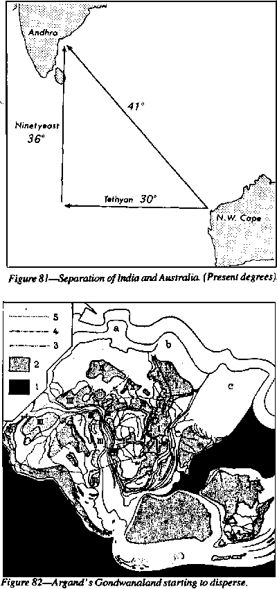 |
Argand in his masterly synthesis La tectonique de l'Asie got the Australia-India connection correct (Figure 82). In 1958, I argued for and adopted this India Australia relationship. Ricon et al. (1990) also adopted this reconstruction, and have been followed by many others. When Gondwanaland is reconstructed on the smaller Earth, the fit of India and western Australia is automatic.
When the Assam-Java sinistral orocline couple is straightened out, the Australian block abuts India beside the Shillong inlier to beyond Assam. Should New Guinea be moved intact with Australia? Yes, because the shallowly-dipping Cambrian limestones continue from north Australia across the Arafura Sea to the deltaic plains of west New Guinea.
In fact, the Australian block was part of the great Paleozoic platform region which extended through Arabia, Iraq, Iran, Afghanistan, Pakistan, India and China right up to the mid Triassic, with a pattern of broad basins and plateaus. Paleozoic orogeny developed along the Pacific borders of Australia and Asia, coherent with the Cordilleran orogeny of the Americas.
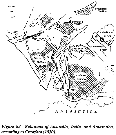
Ahmad (1960), followed by Crawford (1970) found the correct relationship of India, Australia, and Antarctica. Crawford (Figure 83) advanced several reasons, particularly Precambrian isotopic dates, and ancient lineaments in the old shields, carbonatite, lamproite, and charnockite. Ceylon has characteristics more akin to Western Australia than to India.
This match aligns the Tethyan shear system and the Alpine-Himalayan-IndoChina-New Guinea orogenic front, and also the great riverine foredeep, extending through Torres Strait and the New Guinea lowlands, the Indo-Gangetic depression, the Persian Gulf, the Tigris-Euphrates depression, and the Mediterranean.
The Australian
Kimberley nucleus is adjacent to the Indian Shillong nucleus (Figure 44,
p. 66), and the Australian Pillbra and Yilgarn cratons are well matched
by the ancient rocks of the Coromandel coast and Ceylon. "The Proterozoic
Cuddupah basin corresponds to the Australian Nullagine basin. The BIF iron
province of India abuts the Hammersley BIF region of Australia.
 |
Late Proterozoic tillites 180 km south of Turfan were correlated by Norin (1937) with the Australian Adelaidean glacials, and as Crawford points out, the West Australia correlates were even closer. The Late Paleozoic glaciation in Australia, Thai peninsula (Phuket), India (up to Almora and Simla to the lesser Himalaya) were at the outer limit of the maximum of the great ice-sheet, which deposited boulder beds in lacustrine depressions through this zone, but not in the later glacial phases (Figure 6, p. 23).
The Permian
faunas indicate mild climate, as I would predict. The Glossopteris flora
of India closely corresponds to the Australian Glossopteris flora and the
fault remnant Collie Coal basin matches the rifted Bihat coal basins. Kon'no
(1963) reported that the Glossopteris flora near Phetchabun had mixed elements
of both the Glossopteris and Gigantopteris floras, and Visser and Hermes
(1962, p. 67) found the same situation on the Rijsterburgh River in West
New Guinea. This is exactly as should be expected, because on the reconstruction
each of these localities lie in the common tropical area between Gondwanaland
and Cathaysia.
 |
The rift between India and Australia allowed a Jurassic geosyncline to develop between them, but the great widening did not occur until the Paleogene. Teichert (1939, p. 6), referring to a Cretaceous fauna of the Manilya district of the northwest basin of Western Australia commented that:
Teicheit (loc. cit. p. 85) also states that the Buchia - Belemnopsis fauna from Broome in northwest. Australia is very closely related to and partly identical with faunas of Oxfordian and lower Kimmeridgian age in the Timor East Celebes geosyncline, especially on the island of Misool. It is also linked with the fauna of the Himalayan Spiti.
Veevers and Cotteril (1978) placed India continuous with Western Australia south of the angle of Cape Range but were puzzled by the lack of a continent adjacent to the coast trending NE from 3,000 km from this point
Likewise C.R. Johnston found it necessary to ferry Timor back and forth across the fictitious gape to satisfy the proximity demands of Asia and Australia, Archbold et al. (1982) reported the late early Permian articulate brachiopods indicated the geographical proximity of New Guinea and Thailand, and P'an Kiang found that Early Silurian fish implied a similar continuity. Burrett et al. (1990) state:
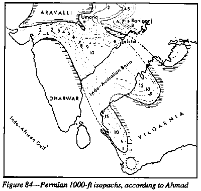
The Ashmore Reef well, situated near the "d" of Indo-Australian Basin of Figure 84 found 130 m of Upper Triassic sandstone shale with some limestone, similar to the contemporaneous Indian and Australian section, followed by 80 m of Upper Jurassic basalts and tuff, implying crustal tension which began the Tethyan carbonate section of 1300m. Veevers ( 1969) has emphasized the correlation of the Triassic-Palaeogene history of the Ashmore Reef, Canning Basin, Roti, Sumba, East Timor. The Sumba-Buru slice of Figure 44 may have been more shortened south-eastward than shown there.
The Shan scarps abutted Australia along the present highlands of New Guinea. The geosyncline northward from Rangoon, including the granitic plutons of Mt Poppa, Salingyi, Banmauk and Nanyaseik, and also the Arakan, Chin, and Naga Hills, developed after the initial parting. The dextral rotation of Malaya has been confirmed paleomagnetically (McElhinney et al., 1974).
The eastern Indian Ocean between India and Australia is simply a rhombochasm, with tensionally faulted coasts at each end and shear confined to the south coast of the Malay Archipelago. The Indus-Tsangpo torsion continues via Red River and the Sorong megashears, then along the north coast of New Guinea. The section from the Indian shield, across the Indo-Gangetic plain and the Himalayas, to the Indus-Tsangpo megashear corresponds to the section from the Australian shield, across the Arafura Sea and Fly-Digul trough and the New Guinea cordillera, to the north coast off the Torricelli Mountains. The summed shift through the contorted East Indies and along the north coast of New Guinea must add up to 3,500 km.