 |
| Home |Introduction | Books & Papers | Animations | Expansion Sites | Science Links | Download |
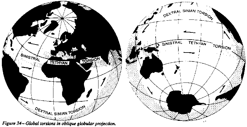
Global Torsions
William Lowthian Green (1875, 1887) pioneered the idea that a sinistral equatorial torsion had occurred between the northern and southern hemispheres, the southern having dragged east with respect to the northern, so that southern continents were consistently separated from the northern by profound disturbance and volcanism.
Green was supported by Daubree, and the Belgian astronomer Wilhelm Prinz (1891), who suggested that a similar gross pattern occurred on Mars, perhaps indicating a similar development of the two planets. Green was completely ignored, like Aristarchus, who proposed heliocentricity 1800 years before Copernicus but was ignored because his conclusion was contrary to the accepted creed.
Working in New Guinea in the early 'thirties, quite unaware of Green's work, I independently came to the same conclusion. In 1938 I wrote:
Half a century ago (Carey, 1945), I reported that the equatorial Tethyan orogenic belt, was a zone of sinistral shear between the hemispheres. More recently, Matte (1986) concluded that major torsion had shifted Gondwanaland against Laurasia.
|
 |
 |
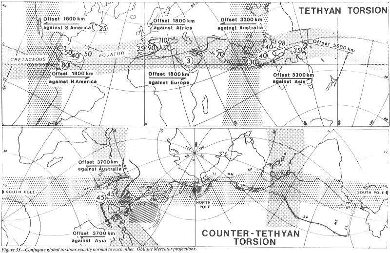
The Tethyan torsion is expressed by large sphenochasms or rhombochasms between rift margins of Gondwana blocks, with major sinistral megashears along the north margins of such rhombochasms or between adjacent Gondwana and Laurasian blocks.
The conjugate torsions differ in another respect. The sinistral Tethyan Torsion has more extensive tensional expansion to the south, whereas the dextral Sinian Torsion has greater extensional expansion to the east (Figure 33).
It is tempting to regard these torsions as mutually normal conjugate shears. This may be so, but it is not a legitimate extension to jump from theoretical conjugate stresses in a plane to a spheroidal surface 10 million times as big, and partly separated in time by 50 million years. (Although the two torsions overlap in time, the Tethyan Torsion precedes the Sinian Torsion in several places).
What could cause such global torsions? Gravity is the dominant force in the Earth, and the lithosphere never departs far from isostatic equilibrium for long. Certainly departures from gravity equilibrium exist, but only of the order of a thousandth of the magnitude of gravity.
The center of gravity of a continental block is 2 km or so higher than that of an equivalent oceanic block in isostatic equilibrium. Hence a continental block, although in gravity equilibrium with oceanic crust, contributes much more to Earth's moment of inertia. If the Earth were rigid, this permanent difference would provide a significant torsion to move the pole until rotation was about the axis of maximum moment of inertia.
Earth is far from rigid to sustained stresses, so that the lithosphere migrates differentially with respect to the mantle. As there is significantly more continent in the north than in the south, the northern hemisphere lithosphere tends to be left behind in the rotation; that is, the northern hemisphere drags sinistrally westward. The viscosity of the outer core is orders lower than the viscosity of the asthenosphere, so the immediate adjustment would occur in depth; but the moment discrepancy is in the crust, so slow lithosphere adjustment must follow.
The Tethyan Torsion developed concurrently with the asymmetric growth of the oceans since the Triassic, which was most rapid during the Cretaceo-Tertiary.
The cause of the complementary Sinian Torsion is not so apparent. Perhaps a dextral torsion normal to the sinistral torsion is automatic. Also, not far from gravity equilibrium, are two large departures from equal radial distance from Earth's rotation axis, which therefore must effect the moment of inertia. The centre of the Pacific Ocean is antipodal to the high Tibetan Plateau, which stands four km above normal continent, and 8 km above normal oceanic crust, so, although in approximate isostatic equilibrium, the antipodean Pacific Ocean and the Tibetan Plateau contribute significant unbalanced moment of inertia, which must disturb the equilibrium of the Earth's rotation, tending to move the Tibetan region westward or poleward. As the Tibetan elevation and the gross Pacific date from the Tertiary, this asymmetry may be the cause, or at least a contributing cause, of the Sinian Torsion.
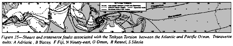
The Tethyan Torsion is a zone some hundreds of kilometers wide of anastomosing megashears, and many transverse rifts. In many places the individual shear zones are severely eroded and show up as lineaments of valleys, with mismatches of terrane or structure.
Within this zone many blocks are sinistrally rotated: Iberia, 40o; Italy, 110o; India, 70o; Arabia, 3o; Guatemala-Yucatan, 85o; Honduras-Nicaragua, 20o, and Newfoundland, 25o. All of these rotations have been confirmed paleomagnetically. Some, like the Riff and Buru Ceram, have been dragged right around through 180o.
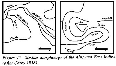
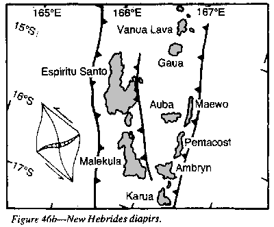
Sinistrally-coupled oroclines also develop, such as the Atlas-Sicily-Italy-Alps oroclinal bends, and the stretched loops through Sumba, Timor, Tanimbar, Ceram, Buru, East Celebes, Sula, Obi and Misool. These imply hundreds of kilometers of inter- hemisphere shift (Figures 43 and 46).
The shears and other fractures of the Tethyan torsion through Eurasia are summarized in Figure 35.
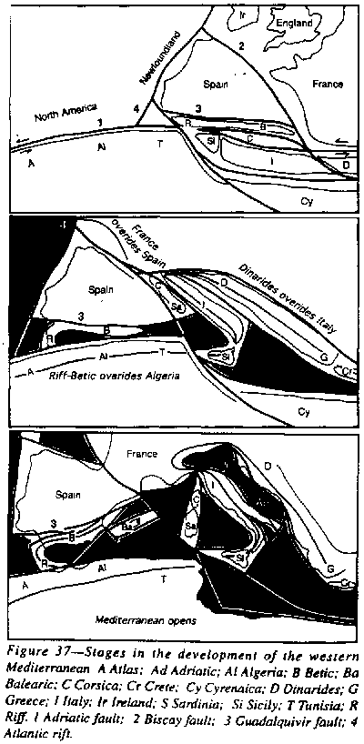
Orogenic trends through the Mediterranean encircle the compass. It is impossible to select a consistent direction of compression, or two, or several.
None of those addicted to crustal shortening as the cause of folding has ever explained why fold axes trend 33o in the Alps, 92o in Algeria, 120o in the Caucasus, 227o in the Apeanines, 246o in Morocco, 252o in the Betic, 278o in the Maritime Alps, 286o in the Pyrenees, 350o in Corsica, and nearly complete a circle in the Riff and Carpathians, all in the confines of one structural province.
This diversity
of trend has to be explained, and any reconstruction must respect the continuity
of the Betic fold belt across Gibraltar through the Riff belt around the
Alboran Sea. Also the continuity of the Atlas orogen, through Sicily and
the Apennines, and the continuity of the Dinarides through Greece, Crete
and Cyprus, and of the great S of the Carpathians from Vienna to Varna,
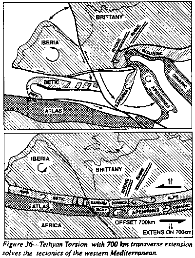 |
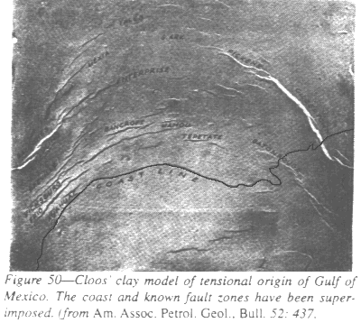
Both these movements continue through sedimentation and orogenesis. The Algerian megashear drags the Riff loop around. and the movement is continued by the rotation of Spain (confirmed paleomagnetically) with the opening of the Pyrenean sphenochasm. At the same time the Balearic Islands and the Corsica-Sardinia block rotated westward, opening the Ligurian and Tyrrhenian sphenochasms, and forming the Sicilian orocline, which takes up some of the megashear's displacement.
The trunk of Italy is also rotated anticlockwise, after receiving conglomerate from then-adjacent Africa. Van Hilten (1961) reported that Permian volcanics near Bolzano had been rotated 107o anticlockwise, contrary to all existing tectonic reconstructions. He added:
The High Atlas and the Jura are secondary to the main diapirism. They are concentrically folded miogeosynclinal strata, absorbing on flat-lying decollements the outward movement of the nappes. Folds of the same kind occur west of the Appalachians. The Swiss Plain is a molasse-filled rift, resulting from the ongoing north-south extension which produced the Mediterranean. How on Earth (literally) could compression produce this?
Topologic homogeneity is maintained throughout. All blocks retain their mutual order No crust is swallowed or mysteriously eliminated. New sea floor becomes permanent. Crustal blocks do not move raft-like through sima, but remain locked to their own underlying mantle. Displacement occurs through moving along transcurrent faults, or the opening of rifts where new mantle rises between. Wedge-shaped opening results in a sphenochasm.
The rotating blocks (Newfoundland, Spain, the Balearic Islands, and the Apennines) are enclosed between main megashears, and the centers of rotation of the several segments fall on these shears. Widening tension rifts run between the pair of megashears. Spain (and the other rotated blocks) remain fixed to their own subjacent mantle, the rotation occurs only by insertion of new mantle crust between them.
This insertion of new mantle may or may not be by growth at "spreading ridges", but may involve the development of new diapiric centers, such as the expanding growth rings which Wezel (1981) describes from the Tyrrhenian sphenochasm as a krikogen.
The whole
process is one of dilation, with sinistral torsion. Africa moved away
from Europe at all stages - never converging or compressing, as taught
in current dogma.
 |
This explains the extraordinary difference between the Western and Eastern Alps, and why Africa has a frontal orogenic zone only as far as Tunis and thereafter the African platform faces the Mediterranean.
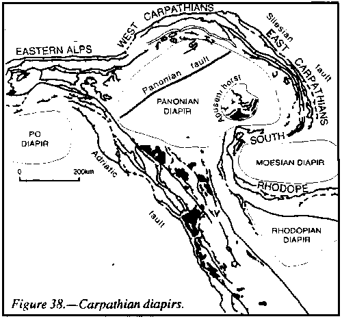
Orogenic zones, which involve incompetent sediment and hotter mantle below, bend, stretch, or pull-apart. Surface area increases. Rising mantle diapirs expand upward creating asymmetric arcs, their size being determined by the thickness of the lithosphere.
 |
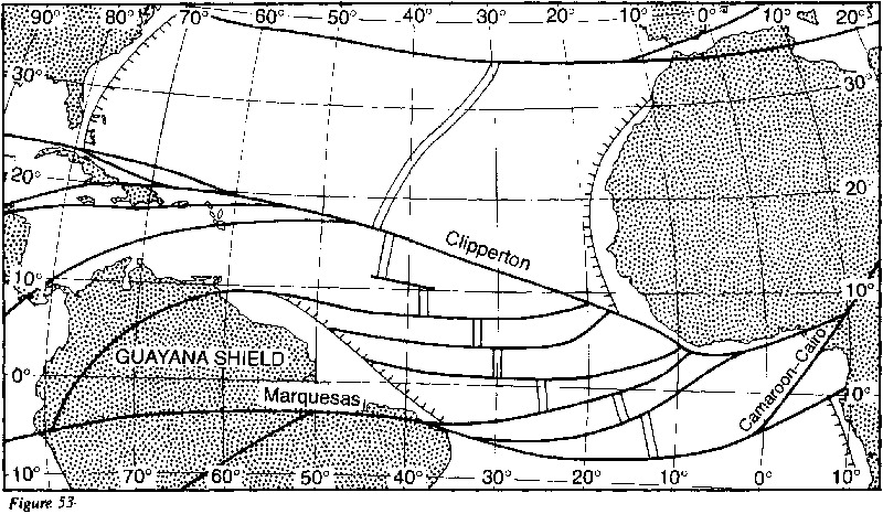
Cyprus has been moved from its Triassic position in the Antalya Basin as part of Turkey some 250 km east by Tethyan Torsion and 200 km south by the regional opening of the Mediterranean (Figure 8, p. 27). Cyprus has been split into three terranes by these processes: the Kyrenia terrane along the north coast, separated by the Mesoria graben from the central Troodos ophiolite terrane, which in turn is separated from the Mamonia terrane by the Polis graben. The Arakapas shear zone, 5 to 10 km wide, trends eastward across southern Cyprus along the southern margin of the Troodos ophiolite, and continues to affect a further 5 km of the Limassol Forest Complex south of the ophiolite. The complex contains east-trending serpentinite shear zones as much as 500 m wide, and more limited development of mylonite. The sinistral nature of the displacement is clearly answered by the trend of the sheeted dikes. Sheeted dikes can only develop in the current direction of progressive opening (see p. 26). The dikes trend north-eastward over an area of more than 200 square kilometers, which is the opening trend associated with the east-west Arakapas shear.
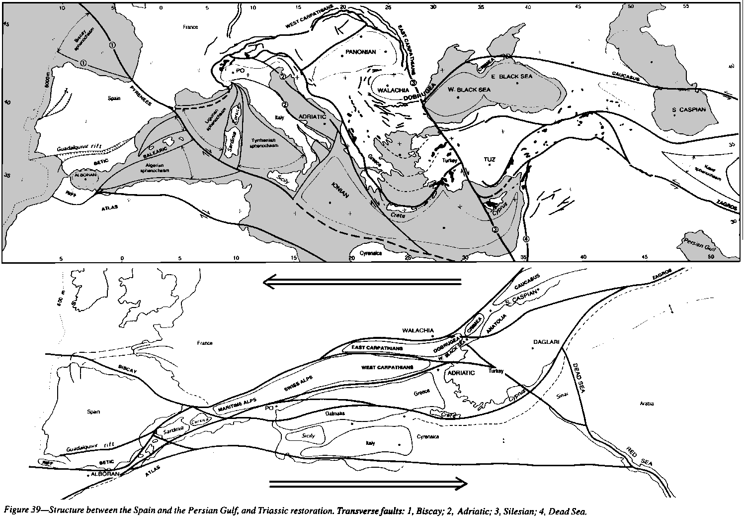 |
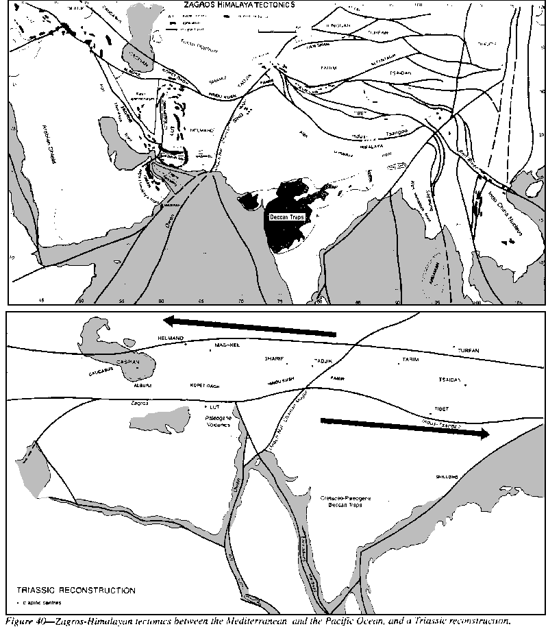
The Tethyan shears continue eastward with bifurcations through Asia Minor to Iran, Afghanistan, and Tibet, the torsion belt widening to 1000 km (Figures 39, 40). The south flank of the torsion flanks Cyprus, trending north-westerly along the Daglari Range, then runs along the southeast coast of Turkey. Of this Kelling and co-authors (l987) wrote:
The Zagros, Alborz, and Kopet Dagh' are not typical orogens, but only one-sided half orogens. They lack the great granite batholiths which are the usual orogenic hearts. Instead of granites they are separated by the wide area of Paleogene volcanics. Just as the Tethyan Torsion in the Mediterranean produced a series of sinistral sphenochasms with north-south stretching, it yielded the Kavir sphenochasm in Iran and separated the Zagros from the Albortz and Kopet Dagh, which are half orogens like the Betic and Atlas (Figures 36 and 39).
 |
The gross mismatch across the crush zone is significant, indicating substantial strike shift. On the southwest side, the Persian Gulf succession of carbonates continues right up to the crush zone. The northeast side is as different as could be - flysch-like detritus and the Kavir Sphenochasm kind of succession. As Wells (1969) wrote:
Just before the crush zone, the Campanian facies grades to marl, shale, then to abyssal radiolarite, with small and large exotic blocks of Jurassic, Triassic, and even some metamorphics and granite, appearing in reverse order in the disturbed radiolarite. High in the sequence are some pillow lavas, and some ophiolite, but not on so massive a scale as in the Oman mountains.
The intensely sheared crush zone is up to 10 km wide, with some identifiable blocks from the carbonate sequence to the southwest. It clearly originated in the late Campanian, but movement was renewed as recently as Pliocene. Current earthquakes are not along it, but seem rather to be below the geosynclinal limb between this line and the Gulf; they are too deep to be due to creep on the Cambrian salt.
The opening of the western Indian Ocean has offset the Alpine-Himalayan front through nearly two thousand kilometers from Oman to the Punjab along the Masirah-Ornach-Nal-Chaman-Mogur sinistral shear system. (Figure 40), which originated as a transverse fault of the Tethyan Torsion, but has been rotated sinistrally during the meridional expansion (like the trunk of Italy, the Red River and Sagaiung megashears). India did not move north, but Arabia arid Africa moved sinistrally southwest against it, opening the Red Sea, Persian Gulf, and the Kavir sphenochasm.
The Tethyan Torsion through the Himalayas and Tibet is distributed between at least four transcurrent megashears between the Indus-Tsangpo and Kun Lun. The Himalayan terrane of nappes between the main frontal fault and the Indus-Tsangpo shear is still dominated, as expected, by plis de couverture thrust tectonics with the intermediate stress axis horizontal (Figure 41)
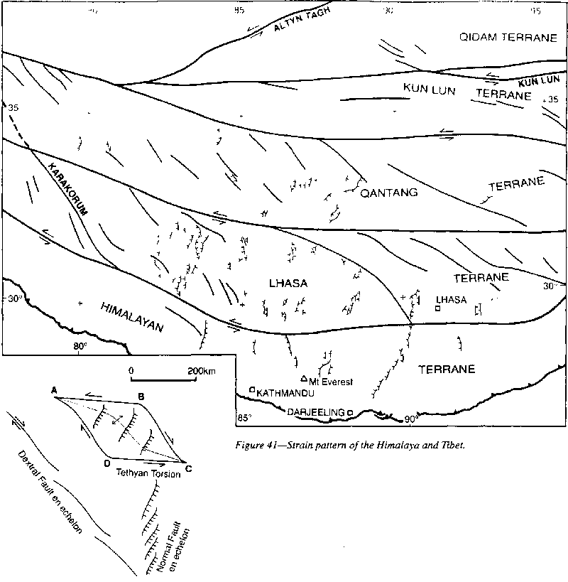 |
The Qangtang terrane between the Banggong and Jinsha shears, and the Kun Lun terrane show much more sinistral first motion, while the Kun Lun Terrane has much Quaternary volcanism. Thermal springs and geysers, which are very numerous throughout the region, seem to be aligned on late north-south tensional fractures. Zonenshain (1973) reports 50 km sinistral shift on the Khangaian fault of North Mongolia.
Sinistral torsion with a large normal component developed along the Altyn Tagh and Nan Shan faults. Melanges with ophiolite and exotics, some as large as city blocks, are typical of the several megashears which trace the Tethyan Torsion through Tibet. Windley et al. (1990) reported that the Tethyan shear zone near Turfan is a mylonitic melange up to 3 km wide, with a sub-vertical zone of similar width.
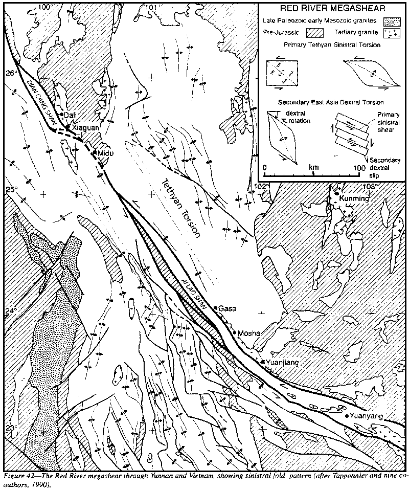
Allen et al. (1991) have described the continuation of the Red River megashear belt, the Xianshuihe fault zone, through 400 km of south-western China. Currently it is the most active fault zone in the world, producing at least eight earthquakes since 1725 with magnitudes greater than 7, with individual displacements at the surface as large as 3.6 m north-westward. With some anastomoses through the bent region of the Assam orocline, it merges with the Kun Lun shears along the north side of the Tibetan Plateau.
Burchfiel et al. (1989) describe 11-15 km of Pliocene-Quaternary sinistral slip on the N6OoW Haiyuan fault that converges with the belt of faults which trend north for several hundred kilometers. The angle and curvature of all the Tibetan faults and folds and their sense of echelon as they converge on this meridional belt clearly indicate that this belt is dextral - belonging to the Sinian Torsion described below.
 |
The core zone, hundreds of meters wide, consists of steeply-dipping strongly-foliated paragneiss with baudins of amphibolite and marble, sheared muscovite-bearing leuco-granite, mylonite and migmatite indicating partial melting. Ubiquitous near- horizontal lineation tends to dominate the foliation to form mullions. Some baudins are hundreds of kilometers; others only tens of centimeters long are separated by meters, an indication of the scale of the shear displacement.
The Red River megashear clearly involved hundreds of kilometers of shift. Formerly its trend was nearly easterly, the continuation of the Indus-Tsangpo and Kun Lun shear system of Tibet, but the southward drag of east Asia to form the Assam-Java oroclinal couple gradually rotated it to a south-east trend, so that the region became exposed to Sinian dextral drag. Indeed, the minor Quaternary movements on the zone have been reported to be dextral.
In Burma a major anastomosing branch of the Tethyan Torsion has been rotated dextrally even more than the Red River megashear until it trends meridionally. According to Mitchell (1993), the strongly sheared belt of the Sagaiung fault (Figure 43) has great displacement, up to I,000 km. Faults in this region start as sinistral megashears but are rotated by the Sinian dextral drag and subsequent shift may be dextral.
The heavily sheared "Jade Belt", that extends 100 km north and 200 km south from Nanyaseik, consists of chert, graphite-, talc-, mica-, kyanite- and glaucophane-schists, amphibolite, and serpentinite. It appears to be the northern extension of this shear zone, but schistosity is widespread across a broad front, so specific correlation may not be possible.
 |
Multiple splays of the Tethyan Torsion traverse South East Asia. The two main ones are the trough lines south of Sumatra and Java and the Andaman. Nias, and Timor groups (the extension of the Sagaiung fault) which separates Australia from India, and the extension of the Red River Fault which separates Borneo and the Philippines from East Asia. The Sagaiung megashear continues the main Tethyan megashear along the western front of the Andaman and Nicobar archipelagoes and the Nias and Timor groups to the loop around the Banda Sea. The Red River megashear continues along the northeast coast of indochina, then along the Natuna Rift and the Billiton depression and veers eastward around the south coast of Borneo. It cuts off the Singapore platform and the Bankga-Billiton ridge.
East of the Red River megashear, the sea floors between southern Borneo and Java have a northeast grain of ridges and troughs in the extensional direction of the south-southeast drag of Borneo. These ridges and troughs are the Billiton basin, the Karimundjawa arch, the Bawean trough which extends across eastern Borneo as the Barito and Tarakan basins, the Bawean arch and the Meratus ridge on Borneo, the Pulau Laut ridge and Kangean basin. The shear along the northwest of the Bawean- Meratus ridge is a deep fault which brings up extensive ophiolite (Ben Avrahm 1993).
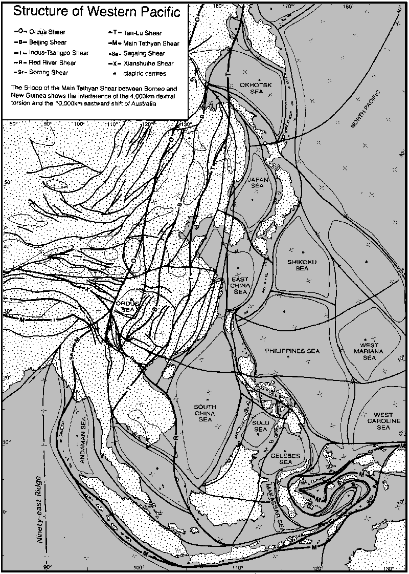
North of the Red River shear extension is the 500 km shift of Borneo from South China, which opened the Brunei Basin (which encroaches on Borneo as the northwest Borneo geosyncline) and the South China Sea of new mantle crust, together with the Sulu and Celebes Seas. Farther north is the well known Philippines megashear, which drags Taiwan south from Korea and Luzon south from Taiwan, and ends southward in the great Banda loops (Figure 43). Northward is the new mantle which rose to floor the Philippines and the Shikoku Seas.
 |
 |
The Sorong fault zone (Figure 43), 4-10 km wide, which Hermes (in Visser and Hermes, 1962) interpreted as a sinistral transcurrent fault, cuts obliquely across the formation boundaries, trends east-west across the north of the Vogelkop and through Salawati Island, where "a chaotic pell-mell of many Mesozoic and Tertiary formations and igneous rocks was found best described as a huge tectonic breccia with extensive mylonite." Neither structure nor stratigraphy match across the Sorong fault zone-they are different worlds.
Eastward, Japen Island contains ultramafic rock cut off by the Sorong zone, which trends east-west across Geelvinck Bay, athwart the grain of the region. South-westward, the Sorong shear zone may be projected as far as Obi, but thence it becomes involved in the Sinian Torsion and we must seek its former continuation further north in the Red River fault zone.
The Owen Stanley megashear system (Figures 9 and 46) is the boundary of the Papuan ophiolite. This sinistral fault zone consists of 5-10 km width of anastomosing, vertical, or steeply dipping, fault slices with lenses of crushed rock. It is clearly a major megashear, but this is not generally mentioned because current dogma regards the Papuan ophiolite belt as an obducted sheet shallowly dipping to the northeast. Indeed the Papuan ophiolite is the "type area" on which the obduction concept was founded.
 |
 |
A great geosuture, running the length of New Caledonia from the northwest tip to the southeast tip, has been described by Guillon and Routhier (1971) who state that its importance has not been adequately emphasized. Rod (1974) added that :
The thrust contact between the ophiolites of Papua and New Caledonia with ophiolite over sediment is not disputed, only the dip of the contact - steep diapiric overriding or flat obduction. Field data and gravity favor the former, only creed the latter.
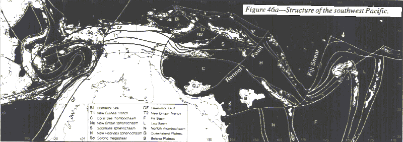
Figure 46 shows the Tethyan Torsion through Melanesia. The main torsion extends the Sorong megashear north of Japen Island, thence to New Hanover, Manus, New Ireland, Bougainville, and the Solomons.
A major branch trends down the central inter-montane of New Guinea, forming the deep trench system of the Mamberamo, Sepik, Ramu, and Markham valleys. But in this section the transcurrent shift seems to be secondary to the overthrusting from the diapirs of the central ranges.
At the Huon Gulf, the trench continues as the New Britain trench and the strike shift greatly increases. The whole area of the southwest Pacific--on the west between Macquarie Island, Tasmania, Australia, and the Oriomo plateau of western Papua, on the east between Macquarie Island, New Zealand, and Samoa, and on the north between Samoa, the Melanesian Plateau, the Solomons, and the Bismarck Archipelago--is a region that has been "exploded"in the sense that the plans of a mechanical complex is "exploded" so that each of its parts is displayed separately.
First, New Britain must be rotated back to lie against the D'Entrecasteaux group to Woodlark Island, closing the sphenochasm of the Solomons Sea, so that the New Britain Trench becomes the direct continuation of the Sepik-Ramu-Markham trench, in this case the locus of emergence of the diapiric fault of the Owen Stanley diapir.
The Gazelle peninsula is offset sinistrally north-westward from alignment with the rest of New Britain on the Wide Bay shears estimated at 100 km by Madsen and Lindley (1994) by matching the Late Oligocene Esis-Sai and Kol dioritic intrusions. They also traced westward for 60 km as a sharp lineament the Weitin fault that cuts southern New Ireland, and its further extension for 250 km along the south coast of New Ireland and New Hanover, part of the megashear through St George's Channel.
A SEAMARC sidescan backscatter survey of the Bismarck Sea has disclosed active spreading ridges and magnetic lineations trending WNW and inactive sulfide chimneys, hydrothermal vent fields, and a small axial volcano.
Next, to restore early Cretaceous configuration the similar sphenochasm between the D'Entrecasteaux- Woodlark ridge and the Louisiade Archipelago is closed. The long island chain between the Ninigo Group, Manus and San Cristobal is shortened and. the rhombochasms of the Solomon and Coral Sea basins closed so that a section north-eastward from Townsville would cross the Great Barrier Reef, the Coral Sea plateau, the Louisiade and Rennel ridges, and the Solomons-Manus chain, without crossing any oceanic crust. This composite terminates on the southeast on the megashear from Flinders Passage to San Cristobal.
The boundary of the Tethyan Torsion parallels New Ireland and the Solomons to its 400 km offset on the San Cristobal shear which offsets the Solomons to the New Hebrides until it is offset 1000 km on the Fiji shear and orocline to Samoa.
North of this line is older crust. The Gilbert, Ellice, Phoenix, and Tokelau island chains represent Jurassic and early Cretaceous expansion of the Pacific. The New Zealand megashear, which follows the Kermadec and Tonga trench to Samoa bounds the Tertiary growth.
The series of sphenochasms which narrow to the west and widen to the east, including the Bismarck, New Britain, Solomons, and Coral Seas, continuing southward into rhombochasms, record the southward movement of the Australian block relative to the outer Melanesian arcs.
The inner Melanesian belt, from Papua via the Louisiade and Rennell ridges, the New Caledonia and Loyalty ridges, and the Norfolk Island ridge to Auckland, has been very greatly lengthened. New Caledonia must be brought back much closer to southeast Papua, which it closely resembles geologically. It has also much similarity with New Zealand, so that section must also be greatly shortened.
Beyond this is the outer Melanesian belt, from Manus and New Ireland, via the Solomons Santa Cruz and the New Hebrides, then the oroclinal sweep to Fiji and Samoa, the ridge splits into four strands, the outer one forming the Tonga and Kermadec ridges. Still another outermost line runs from Musau through the Ontong Java ridge.
The trough between the inner and outer Melanesian ridges corresponds to the Sepik-Ramu-Markham-New Britain trench.
Between the Inner Melanesian Ridge and the Australian craton are several pre-Tethyan broad plateau remnants, including the Coral Sea Plateau, Mellish Rise, Bellona plateau, and the Lord Howe Rise, which correspond to the Oriomo Plateau.
Tethyan Torsion across the Pacific
The Tethyan Torsion is in latitude 45oN at the Alps, add 20oS in the central Pacific (Figure 47), the difference being due to the opening of the Alaskan sphenochasm and the greater expansion of the southern hemisphere.
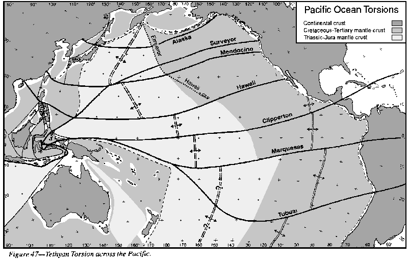 |
The northern
boundary of the Tethyan Torsion belt commences from the northern limit
of Taiwan and the southern end of the Ryuku arc, thence to the inflection
of the Izu and Marianas arcs, thence to the angle between the Emperor and
the Hawaiian ridges, then along the Surveyor shear to enter North America
through Portland, then up the Lower Columbia River. Holocene volcanism
also occurs along this line, extending inland as far as Yellowstone. Between
the Surveyor and Tubuai megashears, is a broad lens reaching a width of
more than 5,000 km. The inflection of each pair of the arcs and small seas
of East Asia, is at one of the Tethyan megashears.
 |
(1) the angle of the Brazilian shield with the Nova Scotia angle of the Canadian shield;
(2) the Andes and Rockies coastal ranges;.
(3) The Mendocino-Idaho coupled oroclines which deflect the Rockies sinistrally 1,100 km as measured on magnetic linear 13, is symmetrical with the Bolivia and Peru coupled oroclines which deflect the Andes sinistrally; the coupled oroclines from Capes Blanco and Mendocino which offset the Rockies and the Andes, and the re-entrants to La Paz and Spokane.
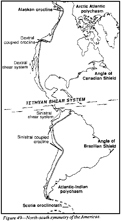
(4) the Alaskan orocline and the Scotia oroclinotath which on the east form the apex of the Arctic-Atlantic polychasm and the South Atlantic polychasm, and on the west return down the East Asian chains and the West Antarctica-New Zealand-Samoa-Solomons chains respectively, with in each case a single, orogenic arc from the orocline with increasing arcs and inter-arc basins towards the equatorial zone. Owing to the greater dispersion of the southern hemisphere, the Scotia orocline is much more dispersed than the Alaskan orocline.
(5) The two major Mendocino and Marquesas megashears are symmetrical.
(6)
The Guatemala and Honduras blocks are also symmetrical about this Clipperton
axis.
 |
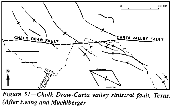
(8) The sinistral Garlock, Chalk Draw, and Carta Valley faults (Figure 51) are symmetrical with the bundle of sinistral shears between Trinidad and Maracaibo.
The Clipperton megashear cuts the American coast as the major shear zone along the Motagua valley, thence along the Cayman ridge, to cut off the south coast of Cuba, and the north coast of Hispaniola, the south side of the Sierra de Monte Christi, and the north coast of Puerto Rico, terminating the Bahamas southward and sinistrally drag the northern end of the Virgin Islands ridge. Across the Pacific it cuts off the Line Islands ridge near Christmas Island and Jarvis Island, thence to the outer Melanesian ridge, cutting off the Caroline Basin (Figure 47).
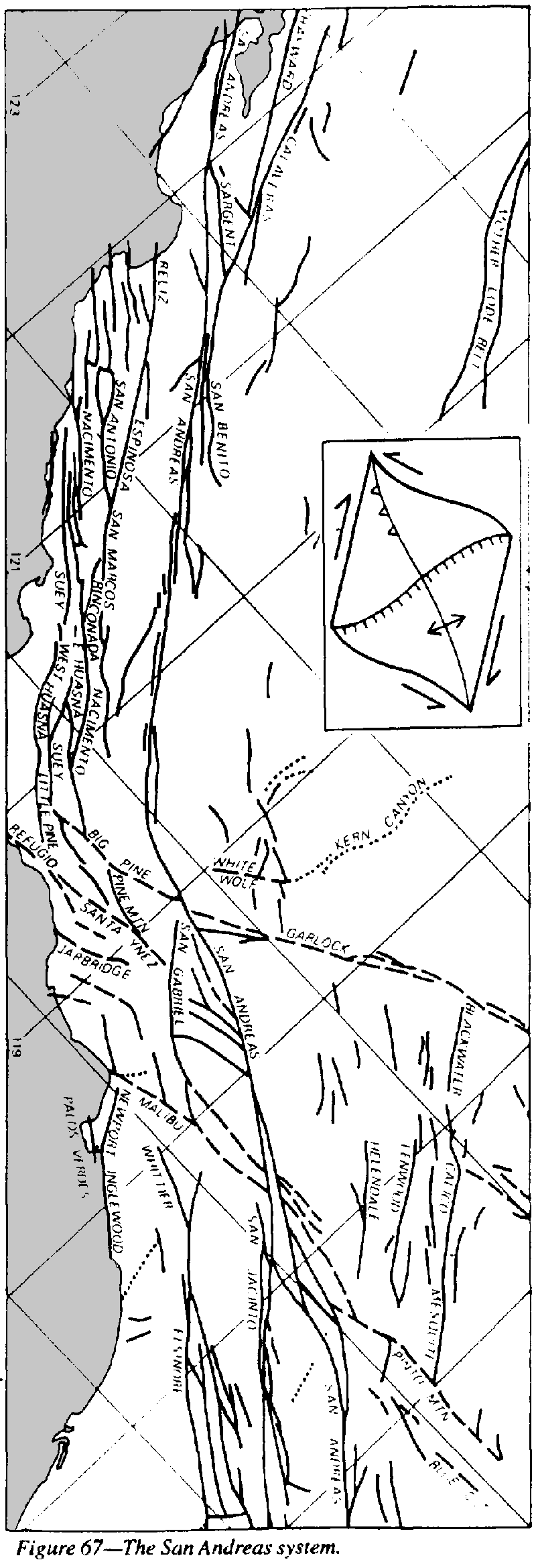
More important than the outer boundary Surveyor and Tubuai shears are the Mendocino and Marquesas megashears, a little within them. The Mendocino Megashear commences from the Mendocino offset of North America (Figure 47) thence to the great bend of the Emperor and Hawaiian Ridges and to the westward bend of the Marianas, to Halmahera. The Mendocino Megashear shifts the main dextral displacement of the San Andreas group more than 500 km to be resumed northward as the Rocky Mountain Trench (Figure 61).
 |
 |
 |
 |
There are other trans-Pacific megashears of which the most significant is the Hawaiian megashear, which springs from southern California, cuts off the Hawaiian ridge at Hawaii and shifts it back to the Line Islands ridge, cuts off the Marshall Islands ridge by the Bikini and Eniwetok Atolls, and terminates the Marianas against the Yap Ridge.
The Murray lineament, after offsetting paleomagnetic linears is collinear with the bundle of transverse faults which deflects the San Andreas system near Los Angeles, then continues as the sinistral Garlock fault, terminates the Sierra Nevada, the Mojave block, the Colorado Plateau, and the Rocky Mountains, and continues through Texas as the Chalk Draw and Carta Valley sinistral faults (Figure 51). Meyerhoff and Meyerhoff (1972) mention that the structural style within the post-Franciscan rocks changes markedly from the northern to the southern side of this lineament.
These trans-Pacific megashears should not be confused with transform faults across the mid-oceanic ridges, the "fracture zones" which are often parallel to them, but are confined to the pulsed growth of the median ridges, and hence do not extend into the continents. Their existence was first proposed by Menard, and brilliantly confirmed by Vine and Mathews (1963).
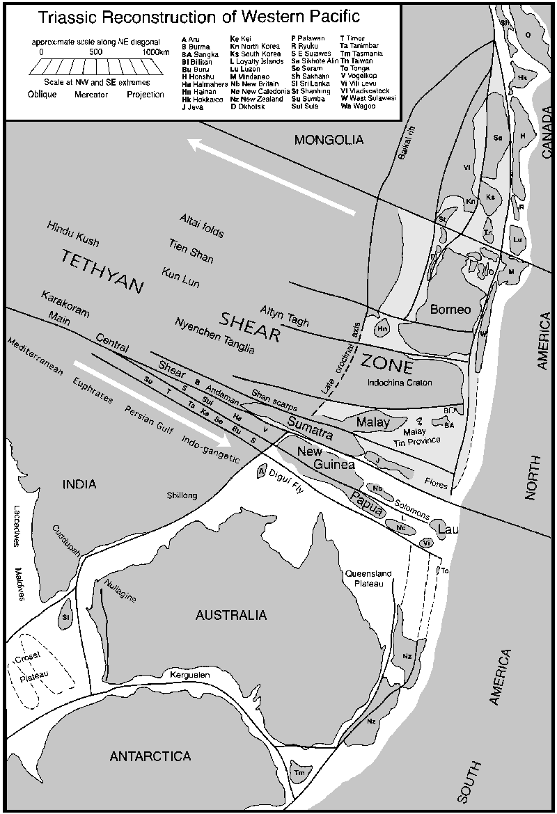
The region between the Hawaiian ridge, the Kuriles and Marianas and Marquesas megashear is pre-Tethyan oceanic floor which had been deformed eastward during the Tertiary.
When the
obtuse bend of the Hawaian Ridge is straightened meridionally, the Metanesian
Ridges are collapsed back on to Australia, and the Australian block taken
back to union with India, these two Mesozoic regions become the Jurassic
Pacific Ocean-all there was of it!
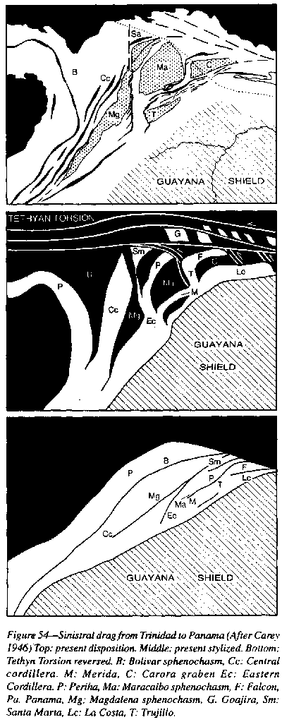 |
In the Panama region the Tethyan Torsion bundle interferes with the Sinian Torsion (Figure 54). At the eastern end of the Caribbean, the torsion belt divides into a major tension fracture which separates Africa and North America opening the North Atlantic, while the main sinistral torsion belt veers south-eastward with oblique tension to merge with the St Paul-Lagos torsion above.
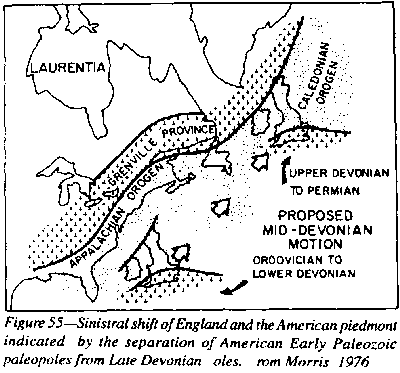
Three hundred million years before the Tethyan Torsion, the Caledonian-Appalachian-Tasmanide orogenic belt had been equatorial (Figure 111), and it to had suffered sinistral torsion. During the Lower Paleozoic, England had been adjacent to Georgia but was shifted in the Devonian sinistrally 2,500 km to its present position (Figure 55).
Morris (1976)
found that the paleomagnetic poles for England, Ireland, Europe and the
American piedmont formed a consistent group from the late Precambrian,
through the Cambrian, Ordovician, Silurian, and Lower Devonian, but this
group was at that time separated from Appalachian and other North American
Paleopoles by more than 30o. When America was moved dextrally
along the Appalachian-Caledonian axial line, all paleopoles became consistent.
The Upper Devonian and Carboniferous poles formed a consistent group for
both the European and American poles without this movement (Figure 55).,
 |
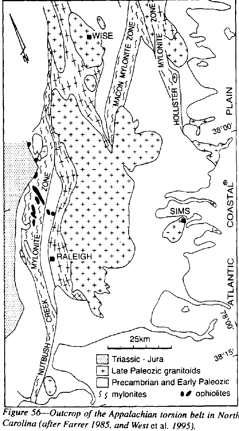
Much of the torsion zone is concealed by younger sediment of the Piedmont. But fortunately the shear zone does crop out in Virginia, North Carolina, and Georgia as a regional mylonite zone several km wide which shifts the Grenville (?) Raleigh series of biotite- quartz-feldspar gneiss against the Avalon correlate, the Carolina Slate belt (Figure 56). A sibling, the Hollister megashear, shifts the Raleigh gneisses against the Roanoke Rapids complex and the Macon shear zone anastomoses between them. Small bodies of strongly sheared ultramafic rocks of ophiolitic association (gabbro through tonalite to trondhjemite and quartz keratophyre) intrude the mylonite zone northwest of Falls, an indication that the megashear penetrates the mantle.
 |
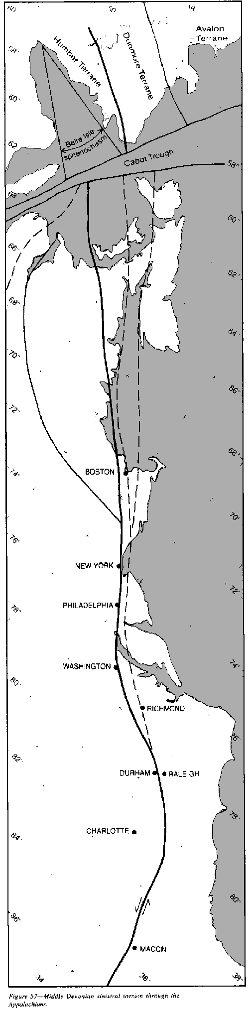 |
Figure 57 shows the main torsion shear in Newfoundland and New England as the division between Avalon terrane and the Humber terrane of the Appalachian front, but in the southern States, some other terranes are included. However the torsion belt is wider and important sibling shears occur. On the Gaspe Peninsula of New Brunswick, "Logan's Line" may be the continuation of the westernmost splay of the torsion zone. The Belleisle Fault, interpreted by some as older, is the north-western boundary of the Avalon terrane, and has a 10 km zone of mylonitization and dyke injection. The torsion zone through Newfoundland is hundreds of kilometers wide with extensive mylonite. Associated igneous differentiates have mantle derivation. The Pocologan mylonite is 1 km wide near Boston. The Caledonian-Appalachian orogenic belt was of course a diapir, so the Wilson model of opening and closing of pre-Atlantic oceans is a myth.
Kay (1968) reported that the Cambrian faunas on the Avalon terrane are virtually identical with the Atlantic province of Sweden, Norway, and Wales, but contrasts strongly with the faunas of western Newfoundland, which have been brought together by the torsion.
Several plate disciples (Wilson, 1966; Dewey, 1969; Burrett, 1972, and others) have emphasized the close apposition of strongly contrasted Ordovician faunas across the Caledonian-Appalachian orogenic axis. Exacerbating this anomaly are the Ordovician tillites over much of Africa (Fairbridge 1969,1970) in close apposition with American Ordovician limestone carrying tropical faunas. Speldnaes (1973) has objected:
 |
Could the Menai Strait fault system between Anglesey and the English mainland, including the Berue and Abere-Diable faults be the British continuation of this major Devonian megashear?
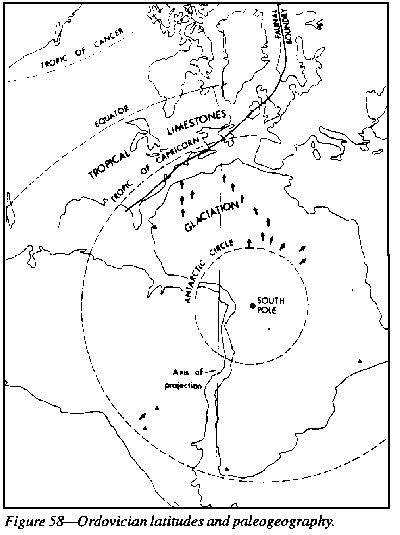
A torsion of
this magnitude should be sought through northwest South America (Figure
58) perhaps between the Guyana and Brazilian Shields. Further south, compare
the alignment of this Middle Devonian megashear on Figure 57 with the extension
of the Appalachian belt into eastern Australia on Figure 111. Is the Middle
Devonian Great Serpentine Belt of New South Wales the continuation of the
Appalachian Middle Devonian torsion? Certainly, a deep fundamental pre-Permian
(?) lineament divides Tasmania along the Tamar Valley with major geophysical
anomalies and pre-Middle Devonian terranes of northeast Tasmania contrasted
against quite different terranes of central and western Tasmania.
 |
Such a major torsion as now demonstrated along the axis of the Caledonides-Appalachides, should certainly have been expressed in the Tasmanides, but has yet to be demonstrated, although there are already significant anomalies.
 |
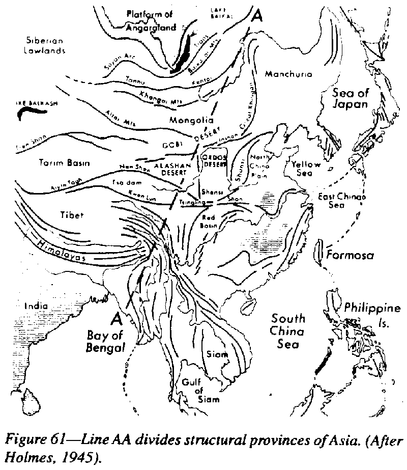
The English geologist, Robert Pumpelly recognized the NNE-SSW tectonic trend of east Asia in 1866 and called it the Sinian trend. Sakuhei Fujiwhara concluded that:
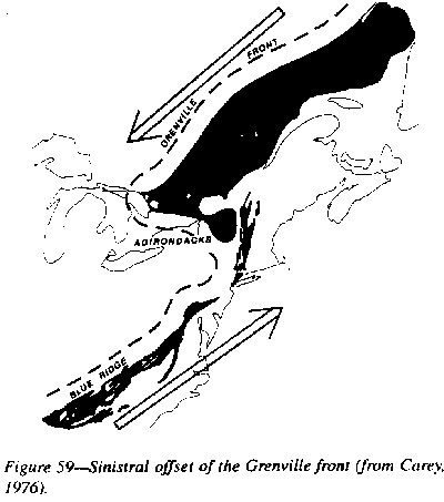
Gregory (1929) divided Asia into two contrasted tectonic regimes on a northeast line from Assam to the Kolyma River of Siberia, E-W in central Asia, and NNE-SSW in the eastern region. This contrast was emphasized by Holmes in 1945 (Figure 61).
 |
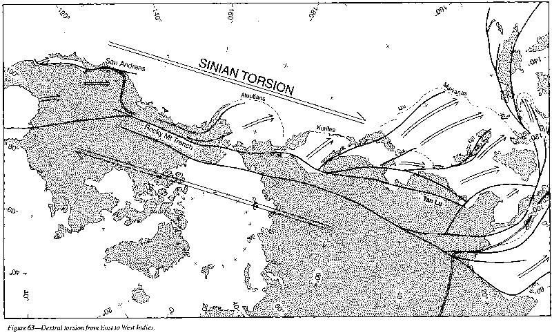
In 1956 unaware of Li's work, I showed that this dextral system extended from Mexico to Borneo bridging the Tethyan sinistral torsion from East Indies to West Indies (Figure 63). (Compare this figure with Figure 43, p. 65).
 |
 |
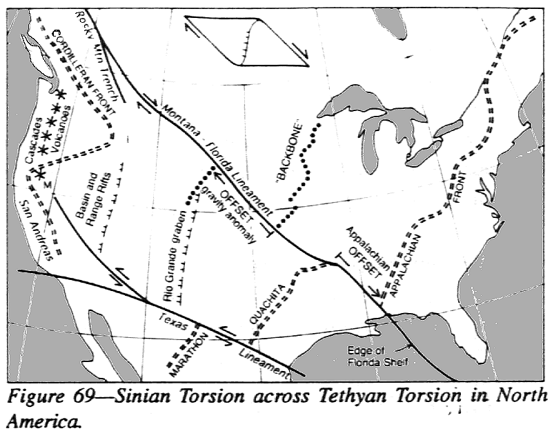
In the northern hemisphere the Sinian Torsion is spread between the Assam Orocline, where the Himalayan trends bend sharply southward, and the Vogelkop Orocline, where the New Guinea trends bend southward, thence up the Marianas to Japan. This zone is shifted southeast by the Tethyan Torsion to extend from the northwest coast of Australia (which originally abutted the southeast coast of India as in Figure 44) to the New Zealand-Fiji line (which originally was the continuation of the Marianas). On the other side of the Pacific, the south-western boundary of the torsion through California was shifted by the Tethyan Torsion of Central America some 3,000 km from its original alignment with the Andes of Ecuador.
The northern limit of the intersection of the Tethyan Shear system and the Sinian Shear system in California is shown in Figure 63, in which the northwest-trending dextral shears represent the Sinian system whereas the easterly-trending sinistral shears are represented by the Big Pine, White Wolf, Garlock, Salhta Ynez, Malibu and Blue Cut shears.
Burma and Malaya, which were orogenically mobile at relevant times, have been rotated dextrally by the Assam Orocline to nearly at right angles to the Himalayan trend. The 45o rotation of the Malay region has been confirmed paleomagnetically (McElhinny, Haile and Crawford, 1974, and by later workers). Away from the orocline, Sinian faults achieve the same displacement. The string of small seas from the Bering Sea to the Banda Sea has been sheared dextrally; disjunctive seas increase in number and size from the pole to the equator.
Chen Gouda et al. (1959) have summarized:
Most Chinese work has been done on the Tan-Lu megashear (a contraction of the towns Tancheng-Lujiang) particularly by Xu Jiawei, including much fieldwork, many published papers, and symposia. From his 1993 symposium volume, the Tan-Lu fault zone extends for several thousand kilometres, but is only 10-50-km wide, which is repeated in other parallel belts over a width of 1,000 km, with 50 or more individual faults making up the belt (Figure 64).
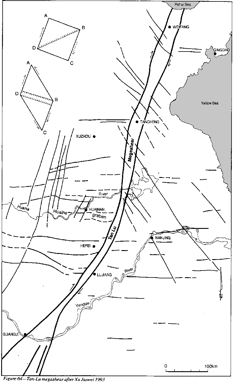 |
The Tan-Lu shear zone commonly crops out as a long straight valley, which is readily identified by satellite remote sensing, its component fault surfaces dipping steeply. Seismic, gravity, magnetic, and electrical sounding surveys indicate that they maintain their steepness in depth.
Mylonite, cataclastic breccia, greyish-green gouge, tectonized and rotated pebbles, and black pseudo-tachylite are common, with some large exotic lens-shaped slices. Greenschist facies metamorphism has developed, with amphibolite facies and glaucophane more rarely. Metamorphic minerals are chlorite, hornblende, sericite epidote, sillimanite, staurolite, garnet, biotite, and chloritoid. Minor Tertiary volcanic intrusions occur and current hot springs. Recent great earthquakes occurred along it in 1668, 1969, and 1975.
In his early paper in 1957, Xu believed the fault to be sinistral and has maintained this view through dozens of papers and symposia since. During the last three decades more than a dozen Chinese geologists have estimated the amount of sinistral offset on the Tan-Lu megashear, by a wide variety of criteria, such as gravity anomalies, magnetic anomalies, facies changes in Paleozoic strata, and cratonic blocks, They started from 100 km, increased to 200, then 400, while Xu's latest estimate based on some 30 markers, is 740 km, initiated during the Late Jurassic to Early Tertiary.
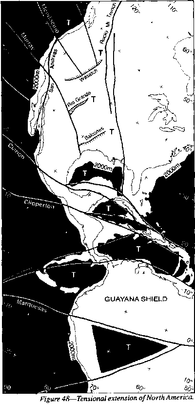
Xu was misled by the stratigraphers' old trap of correlating formations without fossils, and has built up an impressive case for his sinistral offset. None of his "markers" are definitive. The real offset is probably much greater and dextral. Xu's sinistral shift is flatly contradicted by the dextral rotation of Malaya and Indochina and the movement of the peripheral orogenic arcs, and locally by the direction of veering off of splays (to the SSW on the west side and to the NNE on the east side). The total movement of the whole Nocathaysian belt (more than 3,000 km) is finally absorbed by the dextral Assam-Java orocline, and the chain of large tensional openings of Central America at the other end (Figure 48).
Wei Siyu and Teng Jiwen (1993) of the Geophysical Research Institute, Academia Sinica, have studied the stress field indicated by hundreds of Chinese earthquakes. They report:
The Ordos megashear, the westernmost of a great bundle of megashears, is more than 30,000 km long, extending from the Gulf of Siam to the Arctic Ocean, and very straight. It is the line which divides the E-W trends of central Asia from the SW trends of east Asia. It frames the Ordos block on the west under the scarp of the Ala Shan, and determines the valley of the Huang Ho there for 400 km.
South from the Ordos, the megashear forms the eastern edge of the Tibetan plateau, between the Huang Ho and Yangtze Kiang. An anabranch of it shapes the extraordinary hairpin bend of the Yalung Kiang, which then follows it south for 225 km to its T junction with the Yangzste Kiang and three right-angle bends of that river. The Red River Megashear may be offset 70 km by it to resume on the Black River (Nam Te). The Ordos megashear continues south to another T junction with the Mekong, which it follows down to the Thai border. Southward it follows the western edge of the great plain of central Thailand, thence along the western side of the Gulf of Thailand.
North from Ordos, the megashear determines the Hoang Ho valley for 500 km, flanks the Gobi Desert, causes a hairpin bend in the Kohulum Ho, which follows it for 200 km until it to makes a remarkable hairpin bend, it then causes another hairpin bend in the Ling Erhkuna Ho which follows it for 500 km. It then deflects the Lena River and cuts off the Verkhoyansk orogen, then the Kolyma River follows it to the Arctic.
The Beijing megashear is another of the great megashears of east Asia dextral belt. In the vicinity Beijing it is still a very active seismic zone, with many recent earthquakes with magnitude in excess of 7 (Wei and Teng, 1993). The Beijing megashear trends from near Hanoi to the Arctic, a distance of 7,000 km. It forms the western boundary of the great Chinese flood plain from Beijing to Nanjing. It is known as the Zijingguan fault zone and flanks the Taidong Shan. A segment of it is known as the Nanjiang Fault east of the Greater Khingan Mountains.
The Ninety-east Ridge has been assigned every genesis possible for a submarine ridge: a dextral megashear with subsequent transverse widening (like the Adriatic) (Carey 1964, 1969, 1970, 1976), a horst (Francis and Rait, 1967), a subduction crust-swaIlowing underthrust (Le Pichon and Heirtzler, 1968), a fracture zone (McKenzie and Sclater, 1971), a spreading ridge (Veevers, Jones and Talent, 1971) a mantle plume (Morgan, 1972), Von der Borch, (1975), a 'dead' transform fault (Crawford, 1973), an early spreading ridge changing into a transform fault, then to a dextral megashear (Pal, 1972), and an anticlinal margin of an interplate boundary associated with a fracture zone 'of exceptionally great offset' (Bouvin, 1973).
For my part, I confirm my initial conclusion that the Ninety-east Ridge is a dextral megashear, marking the 34o meridional separation of the Indian and Australian blocks (Figure 81), which continues northeast as the axis of dextral bending, drag, and extension between central and east Asia. It continues south-westward from its angle with the Broken Ridge to the northwest end of the Kerguelen Plateau, thence to fringe Antarctica. This Sinian movement is younger than the 30o easterly shift of Australia by the Tethyan Shear (Figure 81) [Figure 81was not included in the preprint editon] along what is now the Java Trench. The Kerguelen Plateau is a large slice of Antarctica from which it hinged on a sphenochasm as Australia and Antarctica separated. It originally lay on the Great Australian Bight between the Australian Nullabor region and Enderby Land. The Crozet Plateau is also a piece of Antarctica originally between Enderby Land and Ceylon.
The Ninetyeast ridge is isostatically compensated, with reduced P velocities, which is probably caused by mantle phase changes caused by initial elevated isotherms, like other oceanic ridges, such as Shatsky, mid-Caroline, and Ontong-Java. The old rift-floor deposits include vesicular basalt, volcanoclastics, lignite, and riverine sediment. Cook (1975) found that the low reflectivity of ulminite in Paleocene coal in DDSP 214 implied sustained low heat flux.
Wiens et al. (1986) have reported that earthquake data (only available from the northern half of the ridge) indicate transcurrent motion. The false standard meme assumes very large compressional subduction into the nearby Sumatra-Java trench, so motion would have to be sinistral. But the Java trench, like trenches generally, is really tensional, and the dextral offset is confirmed by the offset of the Mid-Ocean ridge, the large offset of the Assam-Java oroclinal couple, and the prevailing dextral offset of the whole of the East Asia region, of which the Ninety-east ridge and these other features are consistent parts.
In the southern hemisphere the Sinian Torsion is dispersed all the way from the Ninety-East Ridge (oldest) to the New Zealand Fault (youngest), presumably because it was being continuously spread by the active Tethyan Torsion.
The dextral New Zealand Alpine megashear with its parallel megashear, which runs along the Macquarie ridge via New Zealand and the Kermadec and Tonga Trenches, is the western boundary in the Pacific (Figure 46), corresponding to the Kurile-Honshu-Izu-Mariana-Yap-Palau trench lineament.
New Guinea and the Melanesian region have suffered more severely than most from the subduction blight. Ollier & Pain (1988) summarized this dominance of creed:
 |
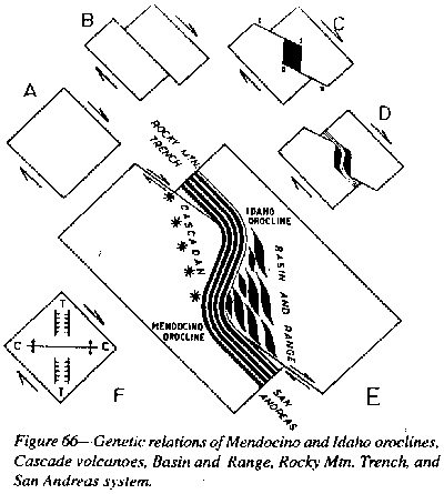 |
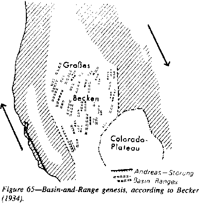
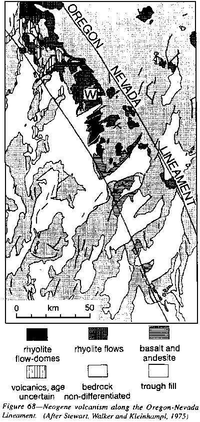
Western North America (like China's Tan-Lu Ordos, and Beijing megashear groups) is dominated by groups of dextral megashears, including the San Andreas group (Figure 65), the Rocky Mountain Trench, the Walker Lane, the Oregon-Nevada lineament (Carey 1976) the Texas lineament (Muehlberger (1965), and the Montana-Florida lineament (Carey (1958), and others. As they suffer rapid erosion, these lineaments are referred to locally as "lanes", thus, the Walker Lane. Billingsley considered the Walker Lane no less significant than the San Andreas family, the two being complementary on either side of the Sierra Nevada diapir. The Oregon-Nevada lineament is the locus of much Neogene volcanism (Figure 66)
 |
 |
 |