 |
| Home |Introduction | Books & Papers | Animations | Expansion Sites | Science Links | Download |
Tethys
According to the ancient Greeks Gaea was goddess of the Earth, descended directly from Chaos. Gaea is the patron goddess of all geologists, whose perennial task is to draw order out of Chaos. Uranus, god of the sea, was Gaea's son by her own father. Gaea bore to her own son Uranus many offspring including the twelve Titans, the three Cyclopes, who ruled thunder and lightning, and the three Centimani, each with 100 hands. Gaea and Uranus also had a daughter, Tethys, who married her own brother Oceanus, one of the Titans.
Homer portrayed Oceanus as a great river surrounding the ancient world, and Hesiod related that from Oceanus and Tethys sprang all the rivers. When Suess ( 1893) extended Neumayr's concept of a Mediterranean sea extending from Mexico via the Alps to the Himalayas, separating a northern continent, Angaraland, from a southern continent Gondwanaland, he recalled the Greek myth and called this equatorial seaway Tethys, daughter of Gaea.
Suess regarded the present Mediterranean Sea as a remnant of his Tethys, which dominated global geography from the Middle Permian until the Early Miocene. This Tethys concept has become firmly established, although the disposition of the continents north and south of it has suffered much shuffling and debate. Suess' idea of Gondwanaland included Africa, South America, India, Australia, and Madagascar, but in his view these continents had always been where they are now, but the oceans between them were subsided blocks of his former supercontinent.
Suess, Lyell, and Dana had always taken it for granted that the positions of the continents on the surface of the globe were fixed and permanent. Their discussions only concerned movements up and down where they lay.
Alfred Wegener, however, concluded that all the continents had been parts of a single great landmass Pangea which was cut along the equator by the Tethys seaway. The present continents became separated, not by foundering of the seas between, but by dispersing, with seas flooding into the opening gaps. He substituted permanence of continental location by permanence of continental material.
Alexander Du Toit followed Wegener in his continental displacement concept, but replaced Wegener's Pangea by two original circumpolar continents, Laurasia in the north and Gondwanaland in the south, with a wide equatorial ocean separating them. When Gondwanaland moved from its southern circumpolar position this equatorial ocean became narrowed on the side between Africa and India and Eurasia, thus forming the Tethys; and squeezing up the Alps and Himalayas.
In this model Tethys was a seaway from earliest time whereas in the Suess and Wegener concepts Tethys only became a seaway from the end of the Paleozoic. In contrast, the model of Vening Meinesz (1952) and Hess (1962) had only a single primary continent around the North Pole, with a totally oceanic opposing hemisphere.
Discoveries during recent decades have confirmed the Wegener model, and almost all geologists and geophysicists now agree that the Arctic, Atlantic, and Indian oceans have all opened since the Paleozoic, with the progressive growth of new oceanic crust between them, and that new oceanic crust is currently growing within the Pacific Ocean. As the radius of the Earth was assumed to be constant, all this addition of new crust in the four oceans had to be balanced by swallowing of other oceanic crust elsewhere. This is the present creed,
Ager (1967) has said that a persistent problem has been whether Tethys should be defined geographically, tectonically, or in terms of lithofacies. He could have added in terms of time, because most restrict Tethys to the Mesozoic, but some recognize Tethys throughout the Phanerozoic. Indeed Tethys has become a football for stratigraphers to such extent that some say that the term has become so diverse in meaning that it should be dropped.
On the question of time, the distribution of Verbeekinidae, particularly the Neoschagerina fauna, leaves no doubt that the Tethys already existed as a throughgoing seaway by the middle of the Permian (see Gobbett, 1967, Fig.1 ). Tethys became an active geosyncline in the Jurassic. The distribution of the Paleogene large foraminifera and of the ostracodes leaves no doubt that the Tethys remained open through the Paleogene. However by the Middle Miocene the throughway had been closed by the rising Alpine-Himalayan orogens and Miocene faunas thereafter developed independently.
Precambrian rocks of the Turkey-Burma region and through central Asia to Mongolia consist of highly metamorphosed mica-schists, marble, hornfels, quartzite, and metatuff, overlain unconformably by widespread non-metamorphosed Proterozoic strata.
The Kahar Formation, of latest Proterozoic age is a monotonous sequence of more than 1,000 m of green argillaceous and siliceous slate with intercalations of quartzite, dolomite, and tuff The Kahar Formation of North Iran and the Alborz, and its equivalents in the high Zagros1 around Golpaygan and Yazd, have much in common with the Morad series of central east Iran. Pale porphyritic Doran granite, in some places with lead-zinc and gold mineralization, cuts through both metamorphics and Kahar
In the Oman Mountains, a basal conglomerate (Mistal Formation of the Huqf Group) is thought to be a tillite. Late Proterozoic tillite 180 km south of Turfan was correlated by Norin (1937) with the Australian Adelaidean glacials, and as Crawford points out, the West Australian correlates were even closer.
Some of the gneisses and other highly deformed rocks through the Himalaya, Tibet, and Indochina, are parts of this Precambrian basement, but many schists have resulted from the late Mesozoic orogenesis. The floor of the Himalayan and trans-Himalayan region, is the ancient Precambrian platform. The central crystalline complex consists of high grade metamorphic rocks, including sillimanite, kyanite, staurolite and muscovite schist, intruded by gneissic leucogranite with a network of anastomosing dikes and sills. Late fluids were rich in boron (tourmaline), phosphorus (apatite), lithium (lepidolite), fluorine (topaz). The Karakoram batholith of biotite hornblende granodiorite is probably late Precambrian but the reported Pb-U zircon age of 95 ± 5 my is probably too young.
Pre-Tethyan basement schists are known through-out the East Indian archipelago - Sumatra, the Meatus Mountains of Borneo as well as in western and central Borneo, Celebes and the Moluccas (Obi) and in Timor, where they are associated with faulted ophiolite.
The whole region, including the Arabian Shield, Somalia, Iraq, Iran, Afghanistan, Pakistan, the Himalaya, Tibet, and Indochina, and the vast Siberian Platform, as well as the Australian craton, was peneplaned in the late Precambrian, and remained a subsiding platform from the late Proterozoic, through the Paleozoic, until the Middle Triassic - four hundred million years of tectonic calm.
Arabia, forms a broad shovel-shaped uplift facing the Red Sea, sloping gently north, northeast, and east. But there were also upwarpings and basins, some of which were isolated enough to develop evaporites.
Paleozoic and Mesozoic beds were deposited on this Precambrian floor, without any orogenic or magmatic interlude, until the late Cretaceous. Much has been written about a Paleotethys. There was no such animal Certainly there were warpings and uplifts which suffered temporary but severe erosion, deep troughs and basins, but no orogenesis, no granite, no flysch. The region was part of the extensive platform which extended from the Balkans to Burma, and lapped south on to the shields of Arabia, the Deccan, and Australia. The so-called Paleotethys before the Jurassic did not exist. In a broad review of Himalayan-Tibetan geology, Gansser (1993) wrote:
The Infracambrian Ediacaran follows the Kahar Formation conformably, but the sharp lithologic break indicates disconformity, and with marked unconformity on a variety of earlier Precambrian rocks. The Ediacaran, remarkably persistent in lithology and thickness (about 2,000 m), consists of purple and variegated micaceous shale, sandstone, thick cherty dolomite, and stromatolitic limestone.
Ediacaran fossils (Dickinsonia, Spriggina, and Medusites asteroides) occur in the Rizu series east of Yazd. A distinctive shale marker traced from the central Albocz to Azsrbaijan contains abundant small disc-like features which closely resemble Beltonella giliesi Sprigg of South Australia, and Fermoria sp. of the Vindhyan series of India. Ediacaran fossils have not yet been found in the Huqf Group of the Arabian Peninsula, but stromatoporites and calcareous algae are present. The flat-lying Valdai complex on the Russian platform conformable below the Devonian and unconformable on the older Precambrian, probably includes Ediacaran correlates.
The Lalun Sandstone, the Cambrian basal unit, conformable on the Ediacaran, is a remarkably uniform and persistent purple-red, cross-bedded, arkosic to quartzitic sandstone 500-100m thick, throughout Iran. It contains "Cruziana" and similar trace fossils, and correlates with the Purple Sandstone of the Salt Range in Pakistan, the Sadan Formation in Turkey, the lower Quweira Sandstone in Jordan, the base of the Haima Group in Arabia, beds near Jeddah and northeast of Medina in Saudi Arabia; beds near Muikalla in South Yemen, Bender Kasaim on the north Somali coast, and the Saramuj Formation in Jordan.
At Kuhbanan northwest of Kerman and also at Janjan the Lalun Sandstone is reduced to its remarkably persistent white "top quartzite" and rests disconformably on Ediacaran dolomite. This "top quartzite" about 50 m thick is always followed conformably by richly fossiliferous Cambrian from top Lower Cambrian Redlichia to Middle to Upper Cambrian trilobites.
Cambrian red sandstone and evaporite occur south and west of Islamabad, and farther south to the Salt Range 800 m of red to purple sandstone, shale and marl with Neobolus and other brachiopods and trilobites. The Purple Sandstone facies and related units of the western part of India, Kashmir, and West Pakistan are widespread in Afghanistan, parts of Iran and Oman. Early Cambrian red beds and evaporite, followed by Middle Cambrian richly fossiliferous shale, and Late Cambrian quartzite, is a recurrent pattern in many countries throughout the world, and probably indicates early Cambrian aridity, followed by a eustatic rise in sea level, and a global equable climate.
In the south, clastics and evaporite (Hormuz Salt) of the Cambrian Huqf Group (Ara Formation), are the first non-metamorphosed sediments that cover the Arabian shield. Salt piercements are known southwest of the Oman Mountains to 30 km into Dhofar. This evaporite facies does not occur north of the Zagros, although there are many younger salt diapirs. .
The southeast coast of Arabia is the raised rim of the Indian Ocean rift "valley", which exposes Precambrian floor overlain unconformably by the Infra-cambrian Huqf Group and with further unconformity by the Cambrian Amin Group. Northwest of this raised rim is a series of broad salt basins which extend 600 km south-westward from the Oman mountains. Before the Tethyan orogenesis and before the opening of the Persian Gulf, this belt probably extended into Iran.
Redlichia, indicating late Early Cambrian, has been found in Iran only near Kerman and in the High Zagros. Middle Cambrian trilobite-bearing limestone and shale occur at Zanjan in Azerbaijan, near Golpaygan in the Alborz, near Yazd in the High Zagros, and in the Kerman-Tabas ranges. Thickness is generally 600 m, but locally may be as little as 20 m (Kerman) or as much as 2000 m (Ozbak Kuh). Similar beds occur in Israel near the base of the Nubian Sandstone. The Redlichia zone extends from Kashmir to China (Yunnan) and in northern Australia.
Marine transgression was universal in the middle Cambrian and indicates a general rise in sea level. Late Cambrian emergence was followed by early Ordovician transgression before the Caradoc-Ashgill glaciation, which did not extend into Iran. This was followed by widespread Llandovery transgression with extensive carbonates.
Contiguity of the Shan-Thai terrane and northwest Australia is suggested for Cambro-Ordovician times by the close faunal affinities seen in the late Cambrian trilobites, Ordovician molluscs, stromatoporoids, brachiopods and conodonts. Taxa such as Spanodonta and Georgina are found only in these two blocks while others have a Shan-Thai North China, Australian distribution. Cambrian limestone extends through the Australian Northern Territory across the Arafura Sea to the southern plains of west New Guinea.
In the Baltic region the Ordovician includes Obolus sandstone and Dictyonema shale, overlain by glauconitic limestone, followed by more limestone and dolomite with bituminous shale, which is distilled for gas in Estonia.
A shelly fauna of Early to Middle Ordovician age has been found in the Amdeh Formation in the Saih Hatat Window south of Muscat. Ordovician rocks also occur in southern Azerbaijan and in the Alborz. A graptolite shale of Lower Ordovician age was encountered in the Oman well Ghaba-1, which overlies a monotonous clastic sequence, whose upper part is dated as probably Late Cambrian by Lingulella cf. nicholsoni.
Ordovician rocks are known at Gahrwal-Kumoan. Ordivician beds underlie fossiliferous Silurian in Kashmir, but at Hazara farther west and in the Salt Range, if Ordovician and Silurian beds were deposited they were eroded before the Carboniferous glaciation. Ordovician flaggy sandstone and shale with orthis and fetid limestone with trilobites brachiopods and cystids follow the Cambrian in the Spiti section and farther to the southeast.
Ordovician to Devonian clastics underlie unconformably the Permian to Triassic carbonate of the Jebel Qamar six-km exotic block in the Dibba zone. Richly fossiliferous Ordovician beds with trilobites and graptolites occur in the Shan States of Burma and extend north into Yunnan and are extensive in Thailand in the Burmese-Malayan geosyncline, followed by Late Ordovician-Early Silurian graptolite shale, which extends through Yunnan, then more limestone.
A major disconformity generally represents the Late Ordovician to Early Silurian interval throughout the central region. Ordovician and Silurian rocks, consisting of shale and micaceous sandstone, have been brought up by salt diapirs on the Arabian Peninsula.
On the Russian platform are Early Silurian marine limestone and marl with Pentamerus shell banks and later semi-enclosed basins (often freshwater) with marly flagstone containing euripterids.
Richly fossiliferous Silurian beds occur in the Tabas area and northwest of Kerman. In north-western Arabia, at least 1,900 m of Cambrian, Ordovician, Silurian, and Devonian shallow marine (with graptolites) have been recorded, also continental clastics and subordinate limestone, with several regional disconformities. Limestone with corals, brachiopods and gastropods follow the Ordovician at Spiti.
In the Himalaya and Tibet, the crystalline basement is overlain by north-dipping Ordovician to Paleogene non-metamorphosed sediment deposited in shallow stable water with many horizons rich in fossils (Chang and Chen, 1973). The sediment correlates broadly with the the Indian subcontinent - Salt Range, the Sakmarian Umaria marine beds, the Eurydesma beds, the Talchir glacials, and the Glossopteris rich Raniganj of the Damuda Group.
Silurian strata are well developed in the Shan States with rich faunas of Llandovery and Wenlock fossils which continue north into south China. Beds with Halysites wadichi have been recorded, followed conformably by Early Devonian. Devonian and Silurian fossils have been found in the Snow Mountains of West New Guinea.
The Russian platform northeast of a line through Warsaw suffered denudation during the Early Devonian. To the southwest are red beds (Old Red Sandstone) containing armoured fish. then marine sandy clay. Red and variegated silty beds extend as far as Vietnam.
The Muth Quartzite 150 m thick straddles the Silurian and Devonian in the Spiti section and contains Pentamerus oblongus which is Middle Silurian. The Muth Quartzite is also found in the Kumoan-Gahrwal area and a similar quartzite occurs in the Lidar valley of Kashmir In the State of Chitral on the Afghan border are richly fossiliferous Devonian limestone, overlain conformably by Carboniferous shale with Fusulina and Bellerophon.
A regional disconformity occurs at the base of the Middle-Upper Devonian, which overlies Lower Devonian sandstone north of Tabas, Silurian northwest of Kerman, Ordovician or Cambrian in the Alborz, and many sections in central Iran. The Late Devonian was marine with thick bituminous limestone and shale which yield important petroleum resources.
The Shirgesht-Ozbac Kuh basin has 7,000 m between the Ediacaran and the end of the Devonian, while on the nearby Kalmorz high the thickness of the same interval is almost zero. The Palaeozoic sequence lying on Precambrian basement is significantly reduced in thickness at Nayband and east of it.
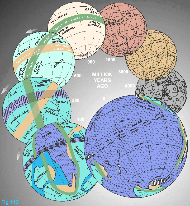
Devonian clastics overlie Ordovician in the south Jebel Qamar exotic block in the Dibba zone, and are followed unconformably by Permian to Triassic carbonate. At one place west of Kerman, Devonian rests on Ediacaran with gentle angular discordance, and wherever Devonian onlaps on to older Precambrian there is sharp angular unconformity. This late Middle Devonian break corresponds to the Caledonian-Appalachian-Tyennan orogeny, expressed in this region only by epeirogenic warping. It may correspond to the beginning of the global shift of the equator from its Lower Paleozoic position to its Tethyan position (Figure 112).
|
A Late Devonian phosphate bed can be traced without interruption for more than 1700 km across Iran from the Bandar Abbas hinterland on the south, through central Iran into the Alborz Range and into Azerbaijan and Armenia. What was the cause, and implication, of this phosphate horizon? A trough margin?
The Plateau Limestone of Indochina, about 1000 m thick, is a fine-grained dolomitic rock which follows the Silurian in the Shan States, and continues conformably into the Carboniferous (with Fusulina elongata and a rich varied fauna) and even into the Permian. Two bands near the base contain a rich Middle Devonian fauna.
In Russia, marine limestone dominates the Early Carboniferous followed by important coal measures, then light-grey limestone with a rich marine fauna in which fusulinids and choristites are characteristic.
Sedimentation from Devonian to Lower Carboniferous was commonly transitional, with the boundary only determined by fossils. Palynologic work has proved the existence of Upper Devonian to Lower Carboniferous sediment in the Haima-1 well in central Oman near the Dhofar border.
The Devonian Muth Quartzite extends into the Carboniferous. In the Spiti section it is overlain by Ferestella shale and quartzite with plants and limestone with Syringothyris and Productus, followed by the Lipak Series of limestone quartzite and shale with abundant Early Carboniferous fossils including Conularia, several brachiopods, pectens and the trilobite Phillipsia, and the Po Series which also contains Rhacopteris.
General Late Carboniferous emergence was perhaps the eustatic fall caused by the Late Carboniferous glaciation, but differential epeirogenic movements also occurred, because all pre-Permian strata were eroded off the Oman ridge, where the Permian rests directly on Precambrian metamorphics. Carboniferous epeirogeny in South Oman and the Arabian craton generally caused gentle folding, perhaps through gliding on salt.
Late Carboniferous to Permian glaciation was general throughout Gondwanaland.
On isostatically positive blocks, the Permian begins with coarse basal conglomerate with igneous boulders. Some are periglacial, with rafting icebergs invoked to explain the size of the boulders. The Al Klata Formation in central Oman has three glacial horizons with bouldery diamictites, probable varves, and glacial striations. These correlate with the Indian Talchir tillites, which are adjacent in the Permian restoration, the Thai Phuket beds, and the Australian glacial formations. But the glacials did not extend far into Arabia, and did not reach Iran (Figure 6).
On the Russian platform separate basins developed, some with limestone, dolomite and marl with brachiopods, others with extensive red beds and evaporites with gypsum, anhydrite, halite, and extensive potash salt deposits.
Permian transgression over an extensive erosional surface, cut in all older formations down to the Precambrian, initiated a new cycle of marine sedimentation. Al-Laboun (1988) states that a siliclastic Permian sheet followed the Hercynian unconformity, and spread throughout Arabia, Iran, Iraq, and Turkey, cutting out along the Arabian nucleus facing the Red Sea, thinner over horsts such as the Haushi-Huqf and Jebel Akhdar blocks, and thicker to as much as 1000 m in the intervening basins. This siliclastic sheet is followed by Permian-Triassic carbonate.
Middle Permian to Cenomanian massive marine carbonate 3000 m thick form the Musandam Peninsula (displaced 300 km south from near Sirjan). From Kuh-e-Gakhum in Iran south-westward through the Saih Hatat and Jebel Akhdar inliers in the Oman Mountains to the Fahud No.1 well 125 km farther southwest, there is a steady decrease in the thickness of the Permian and increase in terrigenous clastic content, indicating Arabian craton provenance, and increasing rate of subsidence toward the northeast. The Arabian carbonate platform of the Permian and Triassic, extended northeast as far as the Zagros-Oman line, but not much further.
South of the Zagros but before the birth of that range, a belt of evaporites was deposited over much of the Arabian Gulf, whereas clastics were deposited in the western hinterland and locally east of the High Zagros. Sedimentation continued without interruption or facies change through the Permian-Triassic boundary. Similar transitional beds of Transcaucasia extend into Iranian Azerbaijan and into the central Alborz, and probably to central Iran, the Zagros, and elsewhere, although in most places the fossil record is not good enough to be precise.
The Permian rests with strong unconformity on Silurian and Ordovician in the Salt Ranges. Permian rocks in predominantly calcareous facies, shallow-water limestone and dolomite, and some anhydrite, lie conformably on lower Carboniferous and Upper Devonian in parts of northern Azerbaijan, in the Alborz Mountains, in the Kohrud Range, north and south of Yadz, and in the Kerman area. Perroian strata rest on Silurian in the south-eastern High Zagros. They rest on Ordovician in Azerbaijan; and on Cambrian rocks in southern Azerbaijan, in the Soltanieh Mountains, in the northern Golpaygan area, and in the central sector of the High Zagros.
Some local basalts and tuffs occur in the upper Permian, then Triassic alkali-basalts, residuals of which now occur at Neyriz-Kermanshah, and in the Oman Mountains and Dibba zone. The Sumeini Grolup crops out on anticlinal inliers below the Hawasina in Jebel Sumeini (Watts and Garrison, 1986), in the Dibba Zone on Jebel Agah, for 14 km along Wadis Ausaq, Khurush, and Al Fay. The Sumeini consists of the Permian to Early Triassic Maqam Formation and the Jurassic to Early Cretaceous Maynah Formation.
Widespread Early Permian basalt extruded in many parts of the platform region. Panjal Traps in Kashmir, the Sikkim lavas, and the Abor volcanics match the Werrie Basalts and Lower Marine basalts of eastern Australia. There is Permocarboniferous volcanism on Borneo with lava, ejectamenta and detritus. These basalt floods, the precursors of the loorzaing change, may have been associated with the 50o shift in the position of the equator which terminated the Appalachian regime and introduced the Tethys (Figure. 112).
Burma's Plateau Limestone is Permian in its upper part ,extending into the southern Shan States near Taunggyi and to Moulmein and the Mergui archipelago. It is overlain unconformably by the Rhaetic Napong beds.
In Malaya, Sumatra and Borneo Permocarboniferous fossils widely occur. In West Borneo are Permian radiolarite and ophiolite. On Timor, and associated islands-Savu, Roti, Leti, Luang and Barbar - are extensive Permian beds with rich faunas.
Carbonate platforms were widespread in the mid-Triasssic in Iran north to the Alborz, Afghanistan, Kashmir, the Salt Range, Burma and Thailand. Evaporite basins developed in central Europe, Iraq and the Zagros. Terrigenous sediments came from both north and south Tethyan margins.
On the Russian platform red beds are widely developed in continuation of the Permian. Middle and Late Triassic deposits are absent, nor is there any Early Jurassic there. The northern flank of the Albortz, subsequently separated by the Kavir sphenochasm, had a continuous Mesozoic-Tertiary sedimentary sequence, nearly as complete as in the south Zagros and in the Persian Gulf trough, except during a short period of gentle uplifting at the end of the Jurassic, corresponding to the Hith evaporites.
Southward toward the Arabian, Indian, and Australian cratons, the Miti Trias saw a general regression and disconformity. Continental clastics of the Minjur Formation were derived from the Arabian shield, but on shore these are overlapped, and the Rhaetic is represented by a disconformity. The base of the main trough in front of the Zagros tectonic zone commenced to stretch and deepen, ultimately to 6000 m, with sedimentation keeping pace.
In the pre-Cenomanian windows of Jebel Akhdar and Saih Hatat are four km of shallow-water limestone and dolomite, the Triassic Haybi volcanics, and the Late Campanian Hawasina marine sediments and melanges.
The Spiti the Early Triassic follows conformably on the Productus limestone and shale. The Triassic consists of 1000 m of black marine fossiliferous limestone which has been zoned on its ammonites, and which grades imperceptibly into Early Jurassic without change in lithology. The marine Triassic sequence is nearly complete in West Yunnan with coal measures near the top.
The Triassic Haybi volcanics, some 400 m thick, which begin as very alkaline but become progressively more tholeiitic, consist of sub-aerial agglomerates breccias and tuffs, with nephelinite, ankaramite, felsic trachyte; then marine pillow basalt, altered to spilitic greenstone, locally interbedded with cherts. They are highly enriched in the incompatible elements (Ti, Zr, Hf, P, Ce, and Nb) and the light rare-earths. Radiometric dating (230-200 Ma) confirms their Late Triassic age. Similar Triassic basalts occur elsewhere along the Tethys belt at Othris in Greece, Mamonia and Kyrenia in Cyprus, Antalya in southern Turkey, and Hatay and Baer-Bassit in Syria.
Glaucophane-phengite schists have been interpreted by Lippard (1983) as indicative of 6 kb pressure. (But the experimental work on the pressure-temperature stability fields of such blue schists has all depended on static confining pressure, not stress-difference, which is the appropriate environment for schistose rocks. Stress-difference substitutes for static confining pressure in non-isotropic minerals, such as phillosilicates and amphiboles).
To summarize, the broad outlines of the pre-Tethyan platform are a regional unconformity below the Infracambrian, followed by a generally stable platform right through to the Upper Triassic. Late Proterozoic glacial episodes, Ediacaran sediments, a wide-ranging basal Cambrian Lalun Sandstone, early Cambrian evaporite basins, Middle Cambrian marine incursions, Early Devonian red beds, an Upper Devonian phosphate marker, Permo-Carboniferous glaciation, and Permo-Triassic red beds: Several broad basins of thick sedimentation, yes, but no orogeny, flysch, coarse clastics, volcanism, nor graphite anywhere in the region. The Upper Paleozoic Spiti trough extended into north-western Australia.
Onshore and offshore rift basins and basaltic dikes and sheets developed all along the Atlantic coast of Iberia, West Africa, North America, and South America as far as the Amazon as widespread Permian tholeiitic basalt heralded the coming Late Triassic storm. Early Triassic alkali-granite and syenite ring complexes in Khordofan are differentiates from ascending mantle magma. The broad continental basins and swells were bordered on the south by the shields of West Australia, India, Arabia, and Africa, with the Nubian Sandstone in the transition. Meanwhile peninsular India and the matching region of western Australia was a stable erosional nucleus until, Permo-carboniferous rifts allowed glacigene, lacustrine, and coal sedimentation, with increasing marine incursions.
Tethys began with the 50o lithosphere shift from the Caledonian-Appalachian equator to the Mesozoic equator (Figure 112) with Permian basaltic floods. and profound ecological consequences. Tethys ended with the 50o shift of the equator from its Mesozoic position to its present position with Paleogene basaltic floods.
Intense volcanism certainly continued into the Jurassic, especially in the Tethyan Rockies and Andes, but no batholiths. Basalts and tephra occur along the west Pacific from Siberia to New Zealand. In the Eurasian Tethys there was little or any volcanism after the Permian basalts between western Europe and Indonesia. Contemporaneously vast sheets and sills of diabase intruded the shelf basins on the shields of Africa, Antarctica, South America and Tasmania with some basaltic flows and pyroclastics.
Beginning in the Permian the Indian Ocean was born as rifts from Baluchistan to Antarctica with Jurassic fauna on India, East Africa and Madagascar.
Following the Permian transgression, Tethyan subsidence and anorogenic sedimentation to more than ten kilometers prevailed through the Mesozoic. A Triassic carbonate platform like the Musandam peninsula of Oman was followed by development of a Cretaceous narrow eugeosynclinal trough with the Spiti shales and radiolarites and finally fossiliferous Eocene carbonate.
Tethys probably started in the Late Triassic as echelon tensional rifts. Horsts of Paleozoic-Armorica, Massif Centrale, the Ardennes and Black Forest massifs, separated the Jurassic basins of Western Europe. On horsts throughout the Kavir sphenochasm (at Takab, north of Golpaygan, and in the mountains south and north of Yazd) are fragments of the Paleozoic stable platform-the familiar Lalun Sandstone and Infracambrian formations, underlying in many localities richly fossiliferous Cambrian beds, on thick metamorphic complexes, or non-metamorphic rocks comparable with the Kahar Formation. Both the High Zagros and the Alborz have numerous horsts of Precambrian rocks with their unmetamorphosed Paleozoic platform beds. The "Gorgon High" near the Caspian Sea is conspicuous. But earlier unconformities are also present correlated with the Cenomanian and Campanian activity elsewhere. In the Alpine region the picture is complicated by decollement on Triassic salt.
The Rhaetic-Liassic disconformity was paralleled by a marked disconformity at the base of thin continental beds and subsequent transition to marine conditions in the upper Liassic. Contemporaneously with the Hamlah Formation limestones of the Persian Gulf, Rhaetic-Liassic coal-bearing sandstone and shale developed throughout the troughs, but change in thickness rapidly from a few tens to more than 2,000 m. This continental facies generally overlies an erosion surface with laterite or bauxite, disconformably on Triassic, Paleozoic, or Precambrian horsts. Up to 5000 m of Cretaceous limestone, marl, and shale occur in the deep trough of central Iran south of the Great Kavir desert, and a similar thickness of shaley Cretaceous near Sanadaj.
The Toarcian-Bajocian interval consists of a few tens to a maximum of 300 m of marine beds. Ammonite-bearing limestone and shale prevail in the Middle and Upper Jurassic in northern Iran, but are replaced by evaporites and reefs in eastern Iran, and by renewed continental deposition and non deposition in central Iran. The thickness of strata in the Jurassic troughs varies from one to five kilometers while at the same time continental deposits or erosion occurred on the nearby horsts.
The base of the main trough in front of the Zagros tectonic zone commenced to stretch and deepen with the, Jurassic varying from 1,000 m in the southwest to 5,300 m in front of the Zagros. The Elphinstone beds at the base include green shale and sandy limestone. A major marine transgression during the Liassic produced a vast carbonate platform with some evaporite, and still substantial clastic influx from the Arabian shield. A Tithonian interval of non-deposition followed, and even erosion of some upwarped areas; some basalt flows heralded the faulting of the Red Sea and the Gulf of Aden, and the diapirism of the Zagros and Alborz.
Climatic conditions became hotter and more arid. The rich Jurassic-Cretaceous tropical to sub-tropical marine faunas of southern and south-eastern India are extensive and well developed in the Kutch, and in the Trichinopoly district, and Cauvery Basin and make ludicrous the plate-tectonic notion of India's Antarctic sojourn at this time.
The northern flank of the Albon, subsequently separated by the Kavir sphenochasm, had a continuous Mesozoic-Tertiary sedimentary sequence, nearly as complete as in the south Zagros and in the Persian Gulf trough, except during a short period of gentle uplifting at the end of the Jurassic, corresponding to the Hith evaporites.
The Iranian region was levelled by late Jurassic and early Cretaceous erosion and covered by an extensive though thin sheet of Neocomian continental redbeds corresponding to the Hith evaporites of the Persian Gulf and world-wide desiccation generally.
Shallow epicontinental sea in the Barremian marine limestone (Thamama) without evaporites followed the discontinuity, with a few meters of thinly bedded crystalline limestone, red-stained by pyritic pellet debris, packed with shell debris - a useful wide spread marker.
A deep graben west of Posht-e-Badam and southeast to near Kerman, suffered rapid subsidence to accumulate 2,000 to 3,000 m during the Barremian-Albian interval. Five thousand meters of Cretaceous limestone, marl, and shale are found locally in the centre of Iran south of the Great Kavir. The carbonate was again interrupted in the Albian by the Nahr Umr shale over most of Arabia. A wideSpread Turonian-Coniacian hiatus followed the Cenomanian, then the Campanian Mi'aidin limestone.
Increasing Campanian global tension along the new Tethyan belt grossly thinned the Zagros-Oman lithosphere, producing deepening fault troughs, the sea floor subsiding in places to more than 4 km, which resulted in marked facies variation. The main source of clastics was still the Arabian craton, fining and thinning north-eastward (then northward) the Aruma Formation, in which globigerines and radiolaria were abundant. Northward, the depth was exceeded at which calcareous foraminifera dissolved before reaching the bottom, and only radiolaria survived. There, silica was colloidal rather than clastic.
The troughs tended to be asymmetric-sloping down from the south, steep fault cliffs on the north; which shed olistostromes, turbidity flows of limestone muds with load casts, cross-bedded sands with ripple marks, limestone conglomerates, and disintegrated derived fossils, all inter-larded with the bathyal sediments, in a series of en echelon troughs of varying depth.
Blocks of Triassic and Permian limestones, and even early Paleozoic beds, slid down, perhaps on Cambrian salt; on to the radiolarian oozes. Some of these exotic blocks were huge. The exposed part of the Jebel Kawr exotic block is at least 1,000 m thick and exceeds 600 km2 in area, with an unknown additional area hidden below the Semail ophiolite. The blocks tend to appear in reverse order- Cretaceous in lower Hawasina, then Jurassic, and Triassic exotics in later Hawasina. Many limestones are recrystallized, some are partly brecciated.
Early geologists (e.g. Lees, 1928) accepted all Hawasina fossils at their face value, and adopted an age spread from Middle Permian to Early Campanian, and regarded all the radiolarite melange as allochthonous. So did Gray (1949) for similar Zagros beds. But later workers and some earlier (such as Harrison et al. 1932) realized that the older fossils were derived from the slumps or weathered from wall rocks, so that an age not earlier than late Campanian has been confirmed. Wilson (1969) set out the Oman structure and stratigraphy correctly.
The false trail, of regarding the derived fossils as indicating the age of the beds which contained them, was the crucial reason why most of the Hawasina, and the overlying ophiolite were regarded as exotic and allochthonous. Then the newly fashionable false creeds of subduction and obduction finally ossified Oman tectonics.
The incompetent
radiolarian oozes suffered irregular crenulation, small-scale folding,
slumping, and melange and chaotic disturbance generally, as well as colloidal
retexturing, as normally occurs in such sediments. Diagenesis produced
porcellanites and red, brown, and green cherts between belts of melange.
The resulting complex has been variously called the Coloured Formation,
the Hawasina Facies,
and
the late Cretaceous Melange.
The Oman radiolarite facies occurs through the Oman region, and continues its northerly trend through Jaz Murian, at Nain in Central Iran, and the Lut almost right up to the Kopet Dagh. Equivalents of the Hawasina radiolarites, with up to 5 km blocks occur in the Makran ranges, near the Zagros fault zone 120 km north of Shiraz (Stoneley, 1981 ), at Kermanshah, and immediately south of the Zagros fault zone, also near the Iran-Turkey border.
Deep troughs of the Hawasina facies continued north through the Lut toward the Kopet Dagh, with radiolarite melanges with exotic rafts, followed by the ascent of ultramafic magma bordered by the Shatori horst. Other narrow horsts such as the Durkah zone popped up along the Zagros zone from near the Turkey-Iran border to the Makran ranges, some to be eroded down to their Precambrian base.
Similar facies occurs at this time in various places along the Tethys. The Neocomian of the Alps includes huge Norian blocks along the Trenner fault line near Berchtesgarden. Burma's Sagaiung fault near Mt Victoria contains exotic blocks of granite, diorite, Triassic sandstone, and Senonian neritic limestone. Likewise, the northern Apennines (Abbate et al., 1970), Cyprus (Robertson and Woodcock, 1979), northeast Syria and Turkey (Dubertret, 1955), and Celebes (Kündig, I956), and others.
As stated by Stoklin (1990), the "Coloured Formation" was first so named for vast colored melanges in the Makram Ranges south of Jaz Murian, referring to the chaotic mixture of striking red green and black cherts, radiolarites, spilites, ophiolitic blocks from contemporary intrusions, and other blocks derived from higher formations. Stoklin found that some of these melange bodies were clearly diapirs which had extruded upward along fault zones. Some had reached the contemporary sea floor and mixed with radiolarian oozes in the bottom of deep grabens. Some had continued to extrude over the sea floor as olistostromes:
Stoklin (1990) has suggested that the colored melange should be regarded as a facies rather than a stratigraphic horizon. This is true from a tectonic viewpoint, but it originated from very deep Campanian fault-troughs, below the solution stability of calcite, in which very incompetent radiolarian oozes had little resistance to differential pressures. The, ophiolite extrusions followed the oozes, and blocks of ophiolite became incorporated in the melanges. Serpentinite contributed to the incompetent flow. Tectonic mixing certainly occurred as late as the Eocene and may even be still going on.
Tanner and Williams (1965) have demonstrated that diapirs only occur in extensional environments. That was certainly true for the Makram region, which was widening by hundreds of km through the later Mesozoic. The transverse widening was commonly great enough to bring mantle rocks to the surface as intermontane seas, and extensive ultramafic extrusions like the Semail, Troodos, Band-e-Ziarat, Rameshk, and many others.
Another factor needs to be added - transcurrent movement. (Several hundred km of sinistral torsion, with transverse widening, occurred throughout the Tethyan belt). Fault-horst blocks may reach the surface from hundreds of kilometers further west. It is not surprising that such melange developed right along the Tethys.
The Mesozoic-Tertiary boundary marked a major global transition-not just the extinction of the dinosaurs, which was a minor consequence - but the gradual 50o shift of the equator from the Tethyan position to its present position, which had climatic (and hence faunal) consequences, but also two profound tectonic implications; first, the onset of the Alpine-Himalayan diapirism, second, the development of the two orthogonal global torsions (Fig. 33).
The end of the Cretaceous brought general epeirogeny, and no Paleogene rocks whatever in the northern Alborz. This Paleogene rise developed into a barrier between the new Tertiary miogeosyncline of the Kopet Dagh and the Aral-Caspian depression. Gravity tectonics flowing glacier like from the rising high of the Alborz produced steep north-thrusting on the north and south-thrusting on the south.
No faulting, only temporary emergence, affected the region north of the Alborz in the Paleocene, followed by renewed subsidence in Eocene-Oligocene. Thickness changes indicate a gradual migration of the trough axis toward the Turanian foreland.
Cretaceous volcanism had occurred in the north flank in the central Alborz, but the Paleogene volcanics only reached its southern flank as a 4,000 m sequence of green tuffs and flows with abundant plant remains (the Karaj Formation). Elsewhere the tuffs are generally marine, but in the complex rift landscape there are broad basins filled to several kilometers with playa-type continental sediments with plant fossils and evaporites.
The Tertiary volcanism of central Iran and the Alborz does not extend into the Kopet Dagh. The long, parallel asymmetric folds of the Kopet Dagh are similar to the Zagros folds. The thickness reaches a maximum of 6,000 m at the trough axis in front of the Alborz and thins regularly northward as the trough axis migrates toward the Turanian shield.
The dominant feature of the Kavir sphenochasm throughout the rifting region, was several kilometers of Paleogene lavas and tuffs, coeval with the Deccan Traps, and Tibetan granitoids. They extended to the flank of the High Zagros, but not on to it; a dozen small granite or diorite plutons occur in the Zagros rifts, about Sanadaj, Hamaden, Golpaygan, Nain, Yazd, and Jaz Murian. They appear to be late differentiates of ophiolitic activity rather than granitic plutonism.
Cretaceous Globotruncana marl, radiolarite and ophiolite, and Eocene flysch from erosion of the rising Zagros complex moved gravitationally as schuppen and minor nappes over the Gulf mio-geosyncline beds, but the Arabian Platform generally, continued much as before right through to the present but with Paleocene disconformities-generally shallow carbonates, local basins of more rapid subsidence, some isolated enough to accumulate salt, gypsum, and anhydrite, particularly the Miocene Fars Formation.
The outer front of the folds, which coincides with the coast of the Persian Gulf and the Tigris-Euphrates valley, is determined only by the expiry of gravity drive from the rising Zagros, and does not imply crustal compression or correspond to any facies change in the sediment. In those areas underlain by the Hormuz Salt, diapirs continued to rise.
Although vigorous vertical mantle ascent of the Zagros diapir occurred in the late Campanian, with extensive ophiolite extrusion, including the Semail, carbonate sedimentation continued in the sinking Persian Gulf region. Harzburgite and lherzolite ascended along tensional rift graben all long the Tethys, as at Montegreve, Monviso, Haute-Ubaye, Lanzo, and Zermatt-Sass in the Pennine Alps; Calabria; the Carpathians; the Dinarides; Pontides; Anatolides; Vourinos, Pindos, Orthris, and Guevgueli in the Hellenides; Troodos, Oman, Papua, New Caledonia, and probably other ophiolite of non- confirmed age.
Regions of most active extension brought ultramafic magmas to the surface. Others, like the Kavir, continued volcanic activity, building great volcanic piles. Where mantle temperatures were not so high, mantle material widened the central zone, forming the small lens-shaped seas of Figure 11. Some of these, fed by a major river or piedmont source, accumulated great thicknesses of sediment.
The Campanian epeirogeny of Iran generally, which resulted in angular unconformities below the Eocene, uplifted the Lut region and created a continental regime that has lasted to the present day. But the Lut troughs were already active in the Palaeozoic.
Regionally, general uplift and erosion marked the late Maastrichtian and early Paleocene so that the Eocene normally rests on various older formations with marked unconformity, including some flysch-like Paleocene in the deep troughs. This Paleocene folding corresponds to the first Alpine folding.
A regional unconformity occurred with the Pliocene folding and uplift of the Zagros belt, which correlates with the extensive diapiric orogeny of the Himalaya. A thick blanket of Bakhtiari Conglomerate spread over the Fars. Extensive concentric folds (long parallel asymmetric anticlines and synclines) developed for three hundred km in front of the Zagros as the weight of the rising orogen pressed laterally on them.
The Fars evaporites behaved plasticly, rising diapirically through the crests of the Bakhtiari folds, with chaotic deformation of the Fars between the Bakhtiari conglomerate and the Asmari Limestone. Decollement also occurred on Tithocrian salt beds. The concentric folds cut out before the Precambrian basement is reached, so the folds do not imply any shortening of the basement.
A group of seven salt diapirs occur in the Yazd-Nain area, another dozen have risen in a belt extend-ing 200 km northward of Kerman, and more than twenty are known in an arc along the northern side of the Great Kavir south of the Alborz. These diapirs have risen from the Tertiary basins, and relate climatically to the Miocene Fars Formation south of the Zagros, but there is also some older salt.
Mantle magma chambers were not continuous along the Zagros fracture zone, and I suggest that the Oman ophiolites represent a series of chambers on the Zagros zone, and that the chord of the present arc lay along the Zagros line before the opening of the Oman Gulf. The ophiolitic activity was much more intense in the Oman, because extensional widening was much greater there.
If the Oman Mountains block is moved back along the Dibba zone across the Makran Coast (omitting the subsequent thick Tertiary sediments) the Semail ophiolites line up with the ophiolites south of the Jaz Murian depression and would extend the Semail ophiolites 160 km northwest. This would imply that the nappe stack never covered the carbonates of the Musandam Peninsula, which lay to the southwest of it.
Continental volcanic activity continued through the Neogene and into the Quaternary, particularly along the southern side of the side of the sphenochasm, and extending to Baluchistan. Mount Demavend (5,670 m), a still active survivor of the earlier Alborz vulcanism, is the highest peak in western Asia. This corresponds to the Quaternary vulcanism of Tibet.
Diapirism began in Tibet when terrestrial redbeds followed marine carbonates in the Lhasa terrane and the andesitic volcanism of the Middle Cretaceous Takena Formation which was folded and eroded. Then followed the Paleocene eruption of more than 1,600 m of ignimbrite, andesite, and rhyolite of the Lingzigong Formation. Great thicknesses of rhyolite-dacite lava and welded tuff, the Majang Formation, occur in the Nyang-Qentangla Range, a 200 km line of 7,000 m peaks which trend north-eastward about 100 km Northwest of Lhasa.
The Gangdese
granitoids, the Trans-Himalayan batholith north of the present Indus-Tsangpo
line, were cognate with this volcanism. The granitoids (Figures 26 and
27) include noritic gabbro, diorite, quartz monzonite, and adamellite.
Nd, Sr, and Pb isotopes indicate that the granitoids
are derived from the mantle with some anatexis with crustal rocks. A dome
near Gilgit at the western end of the belt is found, when enlarged,
to consist of a dozen smaller diapirs from 10 to 100 km in diameter, a
typical diapir complex like the interior of a salt dome. This belt extends
continuously from the eastern to the western syntaxis, the axial zone of
the diapir, originally rectilinear, bowed southward in the Pleistocene.
The Lhasa terrane suffered its first uplift.
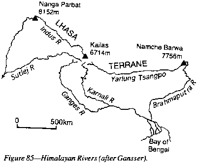 |
Neogene granitic diapirs, likened by Le Fort to a "string of pearls" were the axis of the diapiric zone, which extends for 1300 km parallel to and some 100 km south of the Indus-Tsangpo line (Figure 26). The is two-mica adamellite, with a dense stockwork of aplitic and pegmatitic dikes and sills between neighboring domes. Yamdrock Tso (7,200 m) is south of Lhasa, then Kingmar, Lhagoi Kangri (6,500 m) and finally the 7,700 m Gurla Mandhata, which seems to be still rising. The recognition that Gurla Manhata and Rupshu belong to this belt could prolong it to Zanskar and Ladakh.
The great uplift of Tibet followed. The main igneous axis was in the Kun Lun terrane (Figure 41). Such a mass must spread laterally. The uplifted bulk spread more to the south from this zone than to the north, presumably because the deep mantle below the earlier diapirs was still much hotter than the mantle to the north of the Kun Lun.
The Tibetan region above 5 km altitude is a broad lens 1,200 km wide and 2,400 km long, framed on the south by the Main Boundary Thrust and the arc of the Himalayan nappes, and on the north by the opposing arc of the Kun Lun Shan. The curvature of these arcs is simply due to the bulk spreading of the diapir centered some 400 km north of Lhasa. The very high country is a flat-topped plateau (Fielding et al., 1994), a great lens-shaped isostatically compensated load The northern boundary (the Kun Lun fault) is steep like a normal fault, although it is an upthrust. The southern side reinvigorated the flat-dipping Himalayan nappes which are still moving.
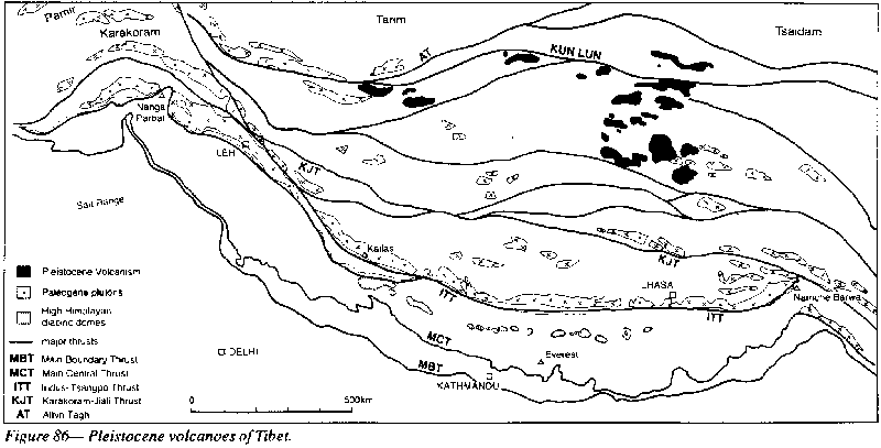
No contemporary volcanoes remain, but in Tibet are Pleistocene potassic-andesite volcanoes with scarcely eroded cones and craters (Deng 1978). The volcanoes (Figure 86) are strung out along the diapir axis for 1000 km between Naichi on the Tibet-China highway and the 6,920 m Chung Muztagh peak in the west on the Tibet border Thermal springs and geysers, which are very numerous throughout the region, seem to be aligned on late north-south tensional fractures.
 |
In 1864 E.R. Wallace wrote:
 |
An arc of Quaternary volcanoes extends from Rabaul for 1000 km along the north coast of New Britain and off the New Guinea coast to beyond Wewak. More than a dozen are currently active, and there have been several Krakatoa-type explosions in the recent past, which have formed the calderas of Long Island, Lolabau, Blanche Bay (Rabaul), Talasea and Lake Dakataua on Willaumez Peninsula.
The arc conforms to the Benioff model in that it parallels the New Britain trench on the concave side, with shallow focus earthquakes on the convex side and intermediate focus earthquakes below the volcanoes.
Although grossly an arc, the volcanoes tend to line up on transverse fractures normal to the arc. Thus on Cape Gloucester are four cones in 15 km between Tangi and Talawe; on Willaumez Peninsula a dozen volcanoes in 35 km lined up normal to the arc; four (possibly more submarine) on a 25 km linear between Mutulus and Kimbe; six in 18 km between Banga and Wulai; and six on the 25 km Ulawan-Lolobau line.
At the southeast end of Papua is another cluster of half a dozen volcanoes, including Lamington, whose explosive eruption killed thousands of people a few years ago. This is on the tensional wedge of the Woodlark sphenochasm.
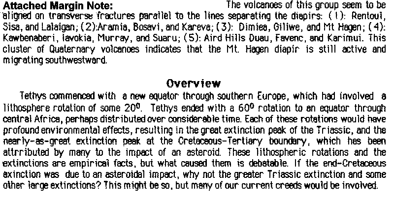
A cluster of
twelve Quaternary volcanic cones occur in an oval area 400 by 200 km, inland
from the Gulf of Papua. They are all tephra-agglomeritic cones rising to
2000 m in a region which had received Neogene marine sediments. They had
short violent contemporaneous lives without lava. All are now extinct or
dormant, except Yelia which still has minor sulfataric activity. They implied
an area of elevated isotherms, probably a tensional rifting region springing
from the edge of the Australian block.
 |