 |
| Home |Introduction | Books & Papers | Animations | Expansion Sites | Science Links | Download |
Earth Expansion
Study of the solar system, and from that to the galaxy, and thence of the cosmos grew for me directly out of the study of Earth, which convinced me that the cause of continental dispersion had been the accelerating expansion of the Earth, which had nearly doubled its diameter since the Permian. If this had occurred at constant mass, the surface gravity would have been four times greater in the Permian, which was patently not true.
Therefore I concluded that, either the expansion was false or the mass of the Earth had also increased greatly. If this were so, the cause was astrophysical and similar behavior should have occurred throughout the solar system, and beyond. Evidence for Earth expansion has been presented in three symposia and my two books of 1976 and 1988.
Sixty years ago, I became convinced that the Wegener hypothesis of continental drift was essentially correct. By 1946, I knew that the ocean floors were spreading at the mid-ocean ridges; as I then assumed axiomatically the standard meme, that the Earth's radius was essentially constant, the added oceanic crust had to be balanced by equivalent removal of an equal area of crust. The only candidate for this function was the trenches.
What I taught my students then was what is now called plate tectonics - slice-by-slice growth of the oceans, balanced by swallowing in the trenches. But my key orocline paper was rejected by the Geological Society of Australia. The Societys' journal would be debased if it published such heresy!
In 1956, I recognized that the continents were rooted to the mantle below them, and realized that my forties model of balancing ocean floor growth by Einschluckung (the then German term, decades later replaced by the American term "subduction") failed crucially when applied to the whole globe. Hence I concluded that the Earth must have expanded from about half its present diameter and be now continuing to expand.
With my colors nailed to the mast, advocating Wegnerian displacement of continents, and, even worse, gross Earth expansion, I was excommunicated from the respectable establishment - "Carey, he's a drifter!" Following my American evangelism of 1959-60 and conversion of my friend, Harry Hess to continental dispersion, the revolution erupted in the late 'sixties under the new name "plate tectonics" (Wegener and continental drift were still dirty words!).
Plate tectonics,
the current dogma, went back to the model I had been teaching during the
'forties. Earth expansion was still taboo, and remains so to this day.
So, a pariah through the past 35 years for advocating continental dispersion,
I have held and still hold that trench subduction is a myth - a false meme
- and that the Earth has been expanding at an increasing rate.
Smirnov (1967a, 1967b), compiling the distribution of heat flux across the surface of the Earth, reported extreme maxima of heat flow over spreading ridges, but equally over young fold belts. All plate-tectonic models assume that cold surface lithosphere is being swallowed in the trenches at rates of up to 20 km3/ year (a conservative estimate, assuming that a 30 km thick plate along a 30,000 length of trenches is consumed at 2 cm/year). Not high heat flux, but several orders lower heat flux should mark the subducting fold belts.
The subduction model cannot be correct. The so called Pacific rim of fire, a global belt of extreme heat flux, cannot be explained as a global belt of subduction. The rim of fire is real. The Pacific rim must be a belt of global diapirism, bringing hot mantle closer to the surface. The plate-tectonic model must be abandoned.
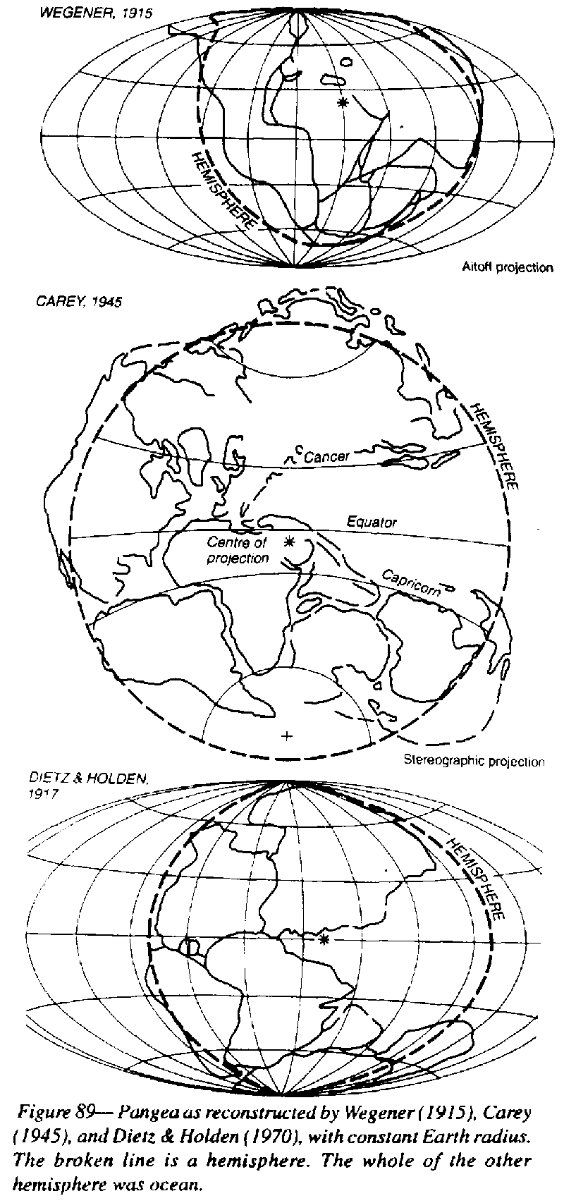
Early in this work, I constructed a semi-spherical table with the same diameter as my 72-inch globe, and spherical molds to mold tracing foil so that I could make accurate comparisons of continental shapes (Figure 89), and so rebutted Jeffreys' repeatedly published claim that there was a 15o misfit between South America and Africa (Carey 1955). This work was followed by Bullard, which resulted in the "Bullard Fit".
The fit is
not perfect. The angle of Brazil has to be pressed hard into the negative
angle of Africa (after removal of the Niger delta), but there is still
a small tapering gap at the bottom of the Atlantic, which I interpreted
as due to my having compared the coasts on an earth of the present radius
instead of on a smaller one (the orange-peel effect of Figure 76). Also
Africa may not be without distortion (as suggested by Internehr and his
co-authors,1988) and perhaps there could be other adjustments.
Reconstructions
of Pangea on my table before the 'fifties, all had a gaping gore between
Australia and South East Asia. Starting from the traditional fit of South
America to Africa, all went well with the South America - Africa - Australia
- Antarctica - India group, and Europe could also be added, but an unwanted
wide gap appeared between Asia and Australia, tapering from zero in the
Mediterranean to 50o between New Guinea and Southeast Asia.
(Figure 89, middle)
|
As new studies continue, additional links keep cropping up: C.R. Johnston had to ferry Timor back and forth to satisfy alternating proximity demands of Asia and Australia; N.W. Archbotd and his colleagues had to do the same to New Guinea to match Permian brachiopods with those of Indonesia.; Clive F. Burrett found that Ordovician cephalopods of the Shan Mountains of Thailand required close proximity with north-western Australia; P'an Kiang found that the Early Silurian fish indicated a similar continuity.
The gape was obviously a false artefact. So I started to reconstruct Pangea with no gap between Australia and Asia, but as I proceeded to assemble the continents a new gape, which was also patently false, appeared between the Americas, widening to 50o. Whatever I tried, I always ended up with a gaping gore from about the middle of the assembly to an unacceptable 50o gape at the periphery.
Finally,
after months of frustration and anguish, I realized that my troubles arose
because I was trying to assemble Pangea on a spherical table the same size
as my globe, whereas I should have been using a smaller table because the
Earth had expanded significantly since the time of Pangea.
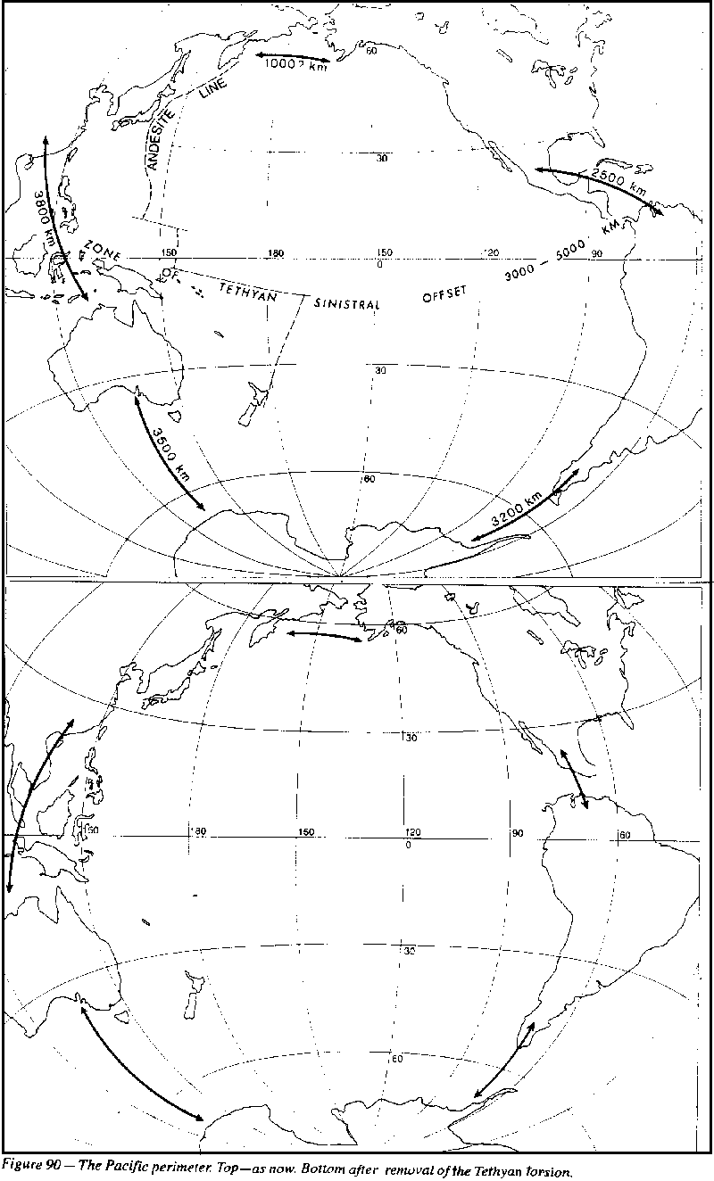
The Pangaea reconstructions by Wegener (1915), Carey (1945), Dietz and Holden (1970), and more recent writers, differ only in detail (Figure 89). All begin by closing the Atlantic, with Pangaea filling a hemisphere and an enlarged Pacific ocean filling the hidden hemisphere.
When examined
from the Pacific (Figure 90, Pangaea reconstructions show Mexico in contact
with Venezuela, implying a subsequent 2500 km extension of the Pacific
perimeter there; Antarctica abutting South Africa, requiring a subsequent
extension of the Pacific perimeter by more than 3000 km across the Scotia
Sea; East Antarctica was nestled into the great Australian Bight - 3500
km extension of the perimeter there; the reconstruction of Australia and
Asia involves 3800 km extension there (Carey, 1970), and the closure of
the North Atlantic implies a subsequent extension across Bering Straits.
 |
Myers (1960) gives a simple model:
 |
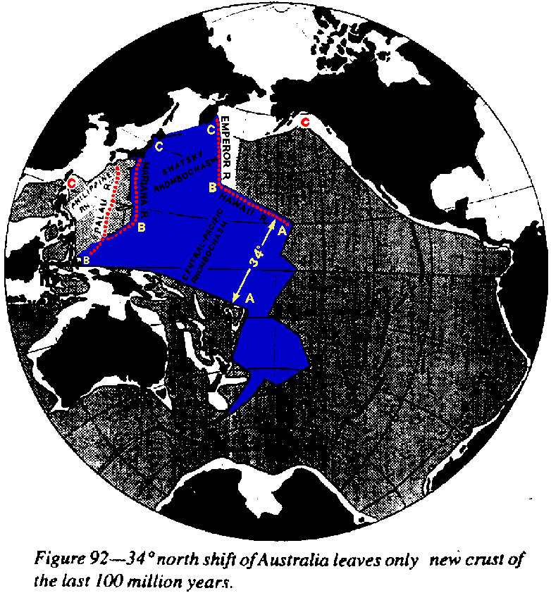
Restoring this
displacement, eliminates the pre- Cretaceous ocean floor, and abuts the
Melanesian Plateau against the Hawaiian Ridge (Figure 92). Elimination
of all the stippled area (ocean floor which has been inserted since mid
Cretaceous) leaves only the new crust of the last 100 million years. Northward
34o shift plus excision of this newly created oceanic crust,
restores Asia and Australia against the Americas. This implies gross expansion
of the Earth since the Jurassic.
 |
 |
 |
The early Pacific
polygon, centered on what is now the "magnetically quiet zone", which had
been growing slowly through the Paleozoic, started in the Cretaceous to
become disproportionately large, so two new spreading zones developed,
one in the west forming the Tasman Sea and the chain of small seas of east
Asia, and the other in the east forming the southeast Pacific rise.
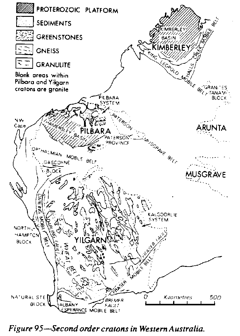 |
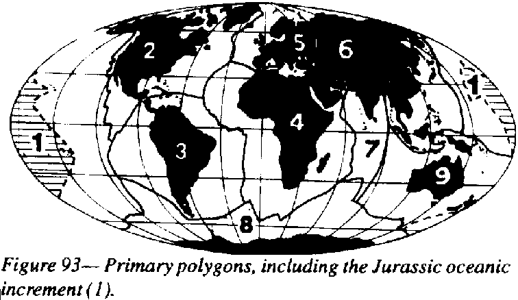
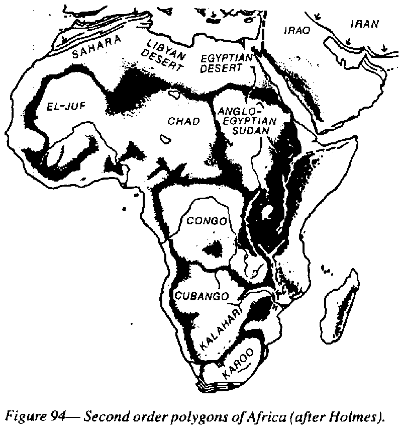
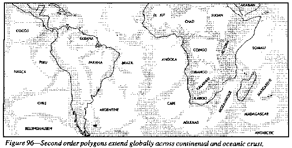
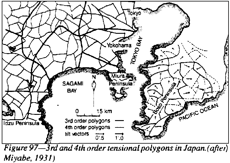
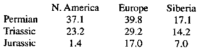
The primary polygons are patterned by second-order polygonal basins and separating swells (Figure 94). A similar pattern of second order cratons is normal, as in Western Australia (Figure 95). A critic once objected that such basins and swells are confined to the continents. Are they? This pattern (Figure 96) extends over continental and oceanic lithosphere throughout the Earth's surface without any significant difference.
Looked at globally,
by far the greatest share of the heat flowing out of the Earth emerges
at the actively spreading ridges between the primary polygons, coming up
all
the way from the core. Away from the spreading ridges the rate of heat
flux diminishes.
 |
 |
Dispersion
of primary polygons
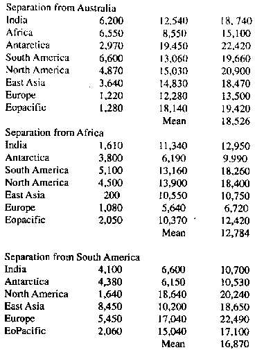 |
The result
in kilometers is set out in Table 3. Each minor arc between every pair
has increased, and each great circle (the sum of increases of major and
minor arcs) has increased by an average of 16,870 km, which is in the middle
of the range Parkinson found (between 12,610 and 22,600) from NASA's
results from the America-Australia arc.
 |
 |
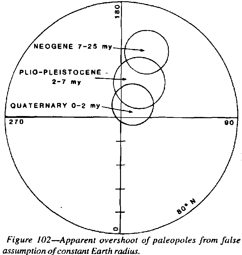
Fossils and
palaeomagnetic data indicate that the Permian equator crossed North America
through Texas and New York. The present equator crosses Brazil 37o
farther south. Hence North America is now 37o nearer the North
Pole than it was in the Permian. Similarly European fossils and palaeomagnetism
indicate the Permian equator about Gibraltar. The present equator is in
central Africa. Hence Europe is now 40o nearer the north pole
than it was in the Permian. Likewise Siberia is 17o nearer the
north pole than it was in the Permian.
 |
 |
The opening of the Arctic basin with Alaskan rotation of nearly 30o counter clockwise with respect to North America since the Cretaceous is clear. So also is the paleomagnetic rotation of Alaska with respect to North America. (Figure 75, p. 89). This combination is quite impossible unless the Earth has expanded grossly since the Cretaceous. The dilemma of the Alaskan Orocline has been presented on pages 88-90.
Briefly, the Arctic sphenochasm has opened by some 30o, and all Alaskan strikes wheel around as expected if they were bent as a complement to this sphenochasm. Hence the framing ranges of the Gulf of Alaska should have closed by this 30o (Figure 75). But paleomagnetic measurements on these ranges reveals definitely that the arms of the Gulf of Alaska have opened by 77o. This situation is impossible. Postulation of subduction does not help. Subduction could leave the arms of the Gulf of Alaska straight, but could not explain their opening in the opposite direction. The impasse is only solved if the surface of the Earth has greatly expanded since the Paleogene (Figure 74).
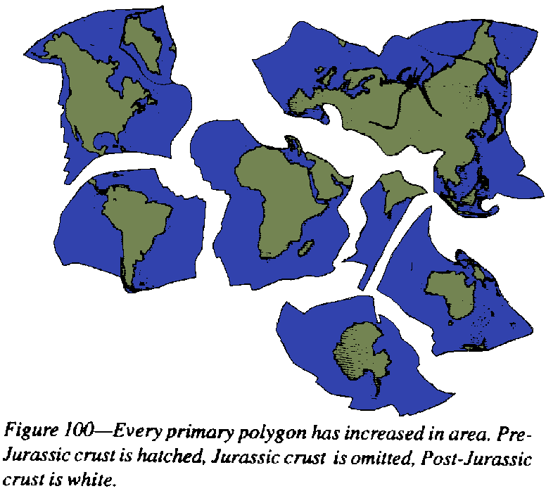
The magnetic
pole orbits the rotation pole in a couple of thousand years (the so-called
westerly drift) but if modern magnetic poles are combined they scatter
closely around the rotation pole. Likewise the palaeomagnetic poles through
the past two million years fall within a small oval around the present
pole (Figure 101).
 |
 |
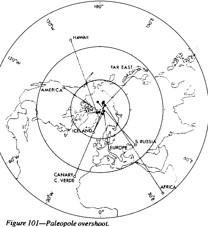
These facts merely bring the Permian-Triassic-Jurassic data up to the present. The indicated overshoot (assuming present Earth-radius) is some 25o for the Permian, 20o for the Triassic, 16o for the Jurassic, 12o for the Cretaceous, 6o for the Miocene 3.5o for the Pliocene, and 1.5o for the Pleistocene. Earth expansion has been progressive.
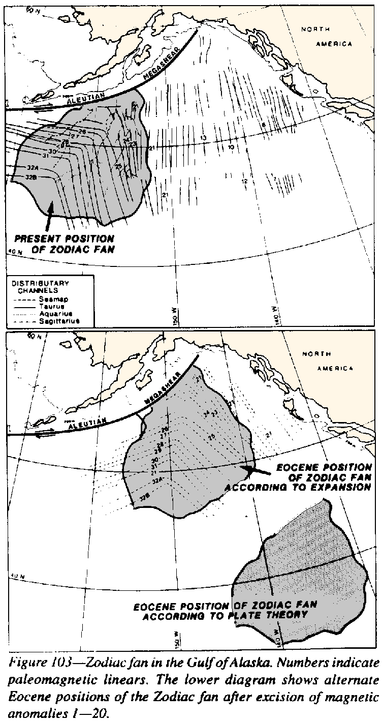 |
In more detail, the Zodiac fan is a composite of four successive fans. The Sagittarius fan, the oldest, is only in the western part (west of the angle of the magnetic anomalies), so when it was deposited, the fan' was a further 700 km northwest, so that the Sagittarius fan lay against the Canadian coast, all the northwest-trending anomalies having grown since. The Taurus fan, the youngest, lies along the eastern side of the fan, still along the Canadian coast. So the Zodiac fan records the progressive opening of the Gulf of Alaska during the Palaeogene, and warrants more detailed study.
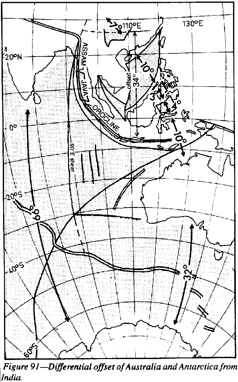
The meridional extension between India and Antarctica is now 66o, but the extension between Antarctica and Australia is about 32o (Figure 91 , p. 117). The 34o difference is taken up by the southward displacement of the Sinian Torsion, which resulted in the chain of East Asian tensional basins, some empty and some already filled with Cretaceous and younger sediments, which add up to an extension of 34o. The Tethyan front is also offset south by 34o by the orocline couple, from east west in Assam, meridional through Burma to Sumatra, returning to its east-west trend in Java. So Australia has been displaced 34o south with respect to Asia (Figure 92, p.117). This is the result of the Sinian Torsion, which separates Australia and Asia
Restoring this displacement, eliminates the pre-Cretaceous ocean floor, and abuts the Melanesian Plateau against the Hawiian Ridge (Figure 92). Elimination of all the stippled area (ocean floor which has been inserted since mid Cretaceous) leaves only the new crust of the last 100 million years. Northward 34o shift plus excision of this newly created oceanic crust, restores Asia and Australia against the Americas.
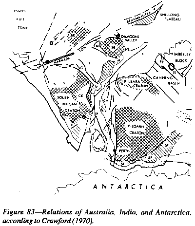
Reversal of the sinistral displacement of the Tethyan Torsion together with this 34o dextral displacement of the Sinian Torsion takes northwest Australia back to its' Madras fit against India (Figures 83 and 84, p. 94).
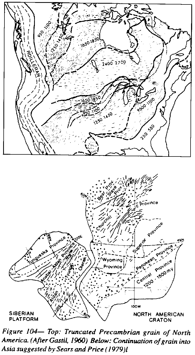 |
The missing continuation of the Proterozoic of North America, which is truncated by the Cordilleran (Figure 104), is to be sought in Asia. Figure 103 is greatly simplified by the addition of the Rocky Mountain Trench-Montana-Florida shear of Figure 69 (p. 84).
The Torlesse facies of New Zealand and New Caledonia require an eastern continental source, which Avias called Archaeofijia, where only deep ocean exists today. Colorado was that source.
A Pacific source is needed for a million cubic kilometers of Devonian micaceous sand in Bolivia, Peru, and northern Argentina, from where only deep ocean exists today. This source was the Australia-Antarctica craton with its Lord Howe and New Zealand borderlands, which during the Devonian abutted South America.
Drilling on the Exmouth Shelf off north-western Australia intersected 619 m of Rhaeto-Norian sandstone and siltstone which came from the north where only deep ocean now exists, and where conventional reconstructions of the Permian would have 5000 km of Tethyan Ocean (Davidson, 1981).
Current creed pairs spreading ridges with trenches. New crust added at the mid-ocean ridges is balanced by old crust swallowed at the trenches. So spreading ridges and trenches should be paired. As mid-ocean ridges grow symmetrically a trench should develop at each margin. But the Mid-Atlantic ridge has no trenches either along the Atlantic coasts of America nor of Europe or Africa. The American side is patched by transferring the trench duty across the continent to the Pacific side. There is nothing on the European side unless it is transferred right across Asia to the Pacific coast, where we find dilational small seas!
Africa is worse, surrounded by its mid-Atlantic mid-Indian Ocean and Mediterranean rift zones, shaped like an inflated caricature of Africa (including its separating pieces of Madagascar and Arabia. On all sides there is new crust, youngest at the active rift and ageing through Tertiary and Cretaceous toward the African coast. Somewhere within Africa the creed demands a subduction sink which has swallowed an area of crust greater than the whole of Africa. No sink is there - only extensional rift valleys! Again the creed is patched up. Africa, alone among all continents, did not move. Africa's subduction problem is transferred across the Atlantic and South America to the Pacific, and across the wide Indian Ocean, across and beyond Australia and the extensional Tasman Sea, to the Kermadec trench. Africa still has a problem to the south - Antarctica.
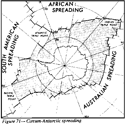
Antarctica (Figure 71) is surrounded on all sides by its encompassing spreading ridge, enclosing an area twice the area of Antarctica, ageing from Quaternary at the rift, giving place to successive epochs of the Tertiary, with still some dating from the Mesozoic. Somewhere within Antarctica the creed demands a central subduction sink, to swallow not only Antarctica's new growth, but also Africa's, because Africa had been pinned. Antarctica has no possible escape, except via Earth expansion.
As Africa has no surrounding trenches, the plate tectonics model claims that 7,000 km of lithosphere has been subducted down the trenches of the southeast Pacific since the Cretaceous (100 km of Africa's Atlantic spreading, plus 1,400 km of South America's Atlantic spreading, plus 3,700 km of Pacific spreading from the mid Pacific rise).
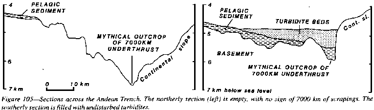 |
The Kermadec Trench is even worse-if that is possible! This trench is required to swallow 13,000 km of lithosphere (one-third of the circumference of the Earth!) during the past 150 million years. Some of the trench bottom is bare rock. Where are the 13,000 km of pelagic scrapings? Where are the great andesitic volcanoes from the processing of so much subducted lithosphere?
The plate-tectonics model assumes Africa not to have moved (or only northward to crush the Alps), and, as pointed out above, requires South America to accept Africa's growth down its Andean trenches. Africa's south-eastward growth then has to be accepted by Antarctica along with her own 1500 km of growth along the line between them. So Antarctica has to swallow 2,000 km of crust, plus as much again of its own within Antarctica, or down a trench on its other side. But no subduction zone exists within Antarctica and no trench occurs on the other side, because Antarctica is surrounded by spreading (Figure 71).
No metamorphic rocks occur in trenches, but glaucophane schists found in orogenic cores are interpreted as former deeply subducted trench sediment, since regurgitated.
All trenches investigated show horst and graben tension structures, not just locally, but for hundreds of kilometers. As Menard, an oceanographer, said (1964):
 |
This field
is replete with solecisms. Only fifty years ago the American creed scoffed
at continental dispersion. Even a biologist as eminent as George Gaylord
Simpson dismissed the evidence of faunal ties between Africa and South
America, granting the Triassic reptiles of Africa and South America only
a degree of kinship consistent with their present separation across a wide
ocean. He compared the percentage of recent Ohio mammals which also occur
500 miles away in Nebraska (column A), the percentage of recent French
mammals which also occur 5000 miles away in northern China (column B);
and the percentage of known South American Triassic reptiles which are
also found in South Africa, now 4,750 miles apart
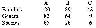 |
Apart from Ager's concern about the distribution of brachiopods, which he believed implied Earth Expansion, many other fossil distribution disjuncts during the Mesozoic are anomalous, such as:
(1) the close relations of Permian corals and fusulinids across the Pacific between North America and East Asia;
(2) the occurrence of Cathaysian cycads of apparent North American origin in Mongolia and Japan, barred from a Bering landbridge by the Arcto-Mesozoic Phoenicopsis flora;
(3) similarly the horned dinosaurs;'
(4) the hungaid calymenid trilobites in Southeast Asia, Australia, and nowhere else;
(5) some 70 graptolite species, common in the Ordovician of eastern Australia and western North America, have higher similarity indices than other regional comparisons;
(6) the Pacific province of Devonian conodonts link east Australia and North America;
(7) Avias (1977) has pointed out that the sedimentary and biotic similarities are very close between Chile-Peru and New Zealand-New Caledonia from the Permian to the Early Jurassic. The New Caledonia flora is highly endemic as befits its Tertiary history, but there are strong surviving links with Australia and New Guinea;
(8) tropical butterfly species with Mesozoic ancestry are widespread in New Guinea and Central America;
(9) Shields (1973) suggests that Australian marsupials entered both Australia and South America via central America before the opening of the Pacific, and that comparative morphology and serology indicate subsequent independent evolution.
(10) Shields (1993) cites several genera which require latitudinal trans-Pacific migration during the Upper Triassic (Carnian), including Lyssoxylon, in Arizona and New Mexico and central Vietnam; Sagenopteris of Honduras and Mexico compared with Yunnan, Szochuan, and Vietnam; Rheticopsis of Arizona with Yunnan and Szechwan; Williamsonia of Utah and North Carolina with Southeast Queensland; Equisetosporites of Yirginia. Arizona, Utah, and New Mexico with the Esk trough and Bowen Basin of Queensland; Cornetipollis pollen from Virginia, Arizona, and New Mexico with Australia's northwest shelf.
(11) The extinct giant horned land tortoises (Meiotaniidae) are known only from Patagonia, Queensland, Lord Howe Island, and Walpole Island.
(12) The mole genus Urotrichus is confined to Japan and California,
(13) The colubrine snake sub-families Xeno-derminae and Pareinae are confined to East Asia and tropical America. The distribution of crayfishes also suggests a similar connection and also links them both with Australia and Madagascar.
(14) The Pterygophorinae sawflies and the scorpion family Bothiuridae are confined to Australia and South America.
(15) In earthworms, Microscolex and Rhododrilus of New Zealand are closely allied to Microscolex and Yagansia of Chile and a Notiodrilus from the Auckland Islands is close to a Patagonian species.
(16) Most of the primitive Lepidopteran families (Micropterigidae, Hepialidae, Neopseusidae, Casrninidae, Megathymidae, Brassolidae) are greatest developed or restricted to the two sides of the Pacific (Shields 1976).
(17) The Cathaysian flora (dominated by Gigantopteris, Pecopteris, and Taeniopteris characteristic of East Asia (China, Thailand, Malaysia and Sumatra) also occurs across the Pacific in South-western North America. Being a tropical flora, it could not have migrated via Siberia and Alaska, nor is it found there. These Gondwana genera seem to have been restricted during the Permocarboniferous glaciation, but evolved and migrated during the equable climates of the Triassic. They could not have survived polar cold, and darkness of a northern route. Mixtures of Gondwana and Cathaysian flora occur at several places along the southern side of the Tethys, for example in the Snow Mountains of West New Guinea. It seems that Cathaysian plants could migrate farther south than Gondwana plants could migrate north. Haug (1956, fig. 96) shows Mexico as the dispersal source for the Indoceras durangense ammonites to Japati, West Australia, New Zealand, and the Alps, and Southeast Asia as the dispersal source for the Middile Bajocian Pseudotoites ammonites to Alaska and Chile.
A vast Pacific continent (!) is inferred by Haug (1960), Kober ( 1928) and others, which should imply that the faunas should show a complete lack of cross-correlation, which they do not (Arkell). To account for the connections between the Lias of Japan and Western North America, and between the Tithonian of New Guinea and Chile, Gregory postulated two separate long, narrow east-west seas dividing the alleged Pacific continent into three parts.
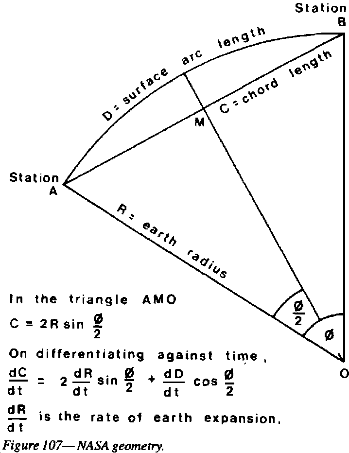 |
The satellite
range is measured by the elapsed time between the emission of a pulse and
its return multiplied by the speed of light. A marginal increase in the
radius of the Earth would reduce this distance, and the chord distance
between stations, and hence reduce the increased distance between successive
measurements of the distances between the stations.Hence
the NASA estimates must be re-examined while allowing for the possibility
of radius change (Figure 107).
 |
This result is pure geometry, quite independent of the presence or absence of any spreading ridges or subduction zones, or any hypothesis. For constant Earth radius dR/dt should have come out at zero. This expansion rate agrees well with the change in the length of a degree implied by the paleopole overshoot during the past 25 million years, and the rate of migration of the Permian equator.
This expansion rate is the same as that found by Jan Kosiar (1991) from a variety of methods, and also nicely accounts for all new ocean floor since the mid Cretaceous. The rate, 2.08 ± 0.8 cm per year, implies that the equator has increased between 12,600 and 22,600 km since the mid Cretaceous; for comparison, the new ocean floor around the equator adds up to 18,300 km, in the middle of the probability range.
Australia through Antarctica occupies one-sixth of a great circle, which on the NASA rate would have expanded by 2,300-3,800 km since the Cretaceous; that, actual opening of the Southern Ocean between Australia and Antarctica is 3,300 km, in the middle of the probability range. Likewise, India-Antarctica now occupies four-tenths of a great circle, so 5,000 - 9,000 km extension is predicted; the actual new crust is a little more than 7,000 km, again in the middle of the range.
lt is significant that the annual expansion rate determined only over a couple of years should fit so well the dispersion of continents throughout the Mesozoic and Tertiary, implying that Earth expansion is not spasmodic but a truly secular phenomenon.
All plate-tectonic reconstructions, commence by closing the Atlantic. If instead of closing the Atlantic we begin by closing the Pacific on a globe of the present radius, the reconstructed Pangaea again fills a hemisphere, but an expanded Atlantic now occupies the hidden hemisphere, an absurdity which is only removed by Earth expansion.
The surface distance between the poles on this assembly is nearly 12,000 km. The present distance between the poles is 20,000 km, that is a 40% expansion since the mid Mesozoic, which is about what the Earth expansion model predicts.
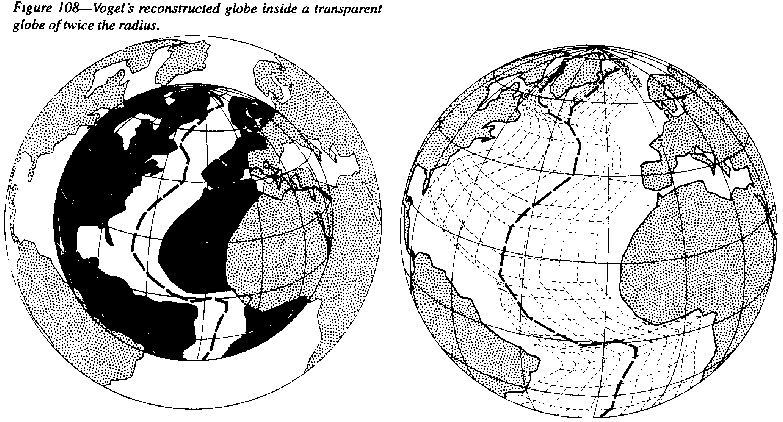
Several workers (Hilgenberg, Kirillov, Brosske, Barnett, Neimann, Creer, Shields, Groves, Vogel, Maxlow, and several others) had shown that all the continental crust could be fitted together neatly on a half size globe without any oceans. But Vogel put his reduced globe inside a transparent modern globe, and this showed that the continents had not slid horizontally thousands of kilometers but had moved out radially (Figure 108).
Dr Ken Perry
(Figure 109) devised a computer program to regress the continents radially
inward, which reversed the growth of the Atlantic slice by slice to complete
closure on a small Earth, incidentally reproducing the magnetic slice pattern
of the ocean floor.
 |
Embleton and Schmidt (1979) juggled paleomagnetic polar wander paths of individual continents seeking a fit to establish early configurations, but found to their astonishment (they had accepted the plate-tectonics meme) that the ancient pole paths of North America, Greenland, Africa, and Australia coincided when these continents remained in their present widely separated positions, indicating that their angular positions with respect to the Earth center now was about the same as they were in the late Proterozoic, implying that the continents had not separated laterally, but had moved out radially, as Vogel and Perry had independently found.
Ager ( 1975), reviewing his 35 years of study of Mesozoic brachiopods, wrote:
 |
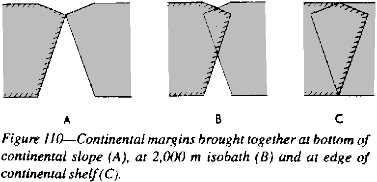
Which isobath
should be used in comparing separated coasts! All would reject the 100-meter
line, the present edge of the continental shelf (A in Figure 110) because
faulting during the breakup would have spread each block. The 2000 m line
(B in Figure 110) is most logical, because the amount of overlap balances
the amount of shortfall. Model C, at the bottom of the continental slope,
is too close and implies a high mountain ridge there before the breakup.
Of course, adjustment must be made for any significant sedimentation since
the separation.
 |
Egyed (1956) observed that continents show progressively less marine transgression through geological time. An Earth with continental crust over the whole surface would be entirely covered by some 2 km of water except where high mountains protruded (which is not true because there were large areas undergoing surface erosion in the earliest geological record). An oceanic area holds more than twice the water volume as an equal area of continent. The implication is that the Earth's surface has increased with time by progressive increase in the area of ocean basins relative to the constant area of continent. Egyed assumed that a constant volume of water, whereas water volume has continually increased through volcanic emission, which makes the argument stronger. The area of ocean and the volume of water have both grossly increased compared with the area of continent, which implies an expanding Earth, irrespective of any alleged subduction.
The end of the Cretaceous saw a global fall of sea-level by some 600 m. On a constant-Radius Earth, where did the lost of 650 million cubic kilometres of water go? Not on to the land because it was not a time of glaciation. Not into continental seas, being a time of general regression. Earth expansion widened the new Mid-Oceanic Rift system thus increasing oceanic capacity. Fluctuating sea levels have recorded the balance between ocean floor spreading and addition of cognate juvenile water.
I have already indicated, that if the Earth had formerly half its radius, mass must also have been much less, for otherwise the gravity acceleration at the surface would be four times its present value, which would certainly have been apparent from several phenomena.
Nernst (1920), followed by Hilgenberg (1933) and Egyed (1956), believed that the aether was a pool of energy which supplied the needed mass. Halm (1935) thought that Earth expansion related to the Hubble expansion of the Universe and that the radius of the hydrogen atom increased. Dirac (1937) studied large dimensionless cosmological numbers and argued that the gravitational constant has changed with time. He was later followed by Jordan (1952). Keindl ( 1940) and others have postulated an early metastable superdense Earth's core that expanded to present density.
For my part, I point out that no "free lunch" is involved because mass and energy are opposites (see Chapter 3), that E=mc2, and that mass and potential energy appear from nothing like Siamese twins, or like a bank loan and its complementary debt, that one cannot exist without the other, that they appear together from nothing and may vanish together to nothing, which could happen anywhere. The problem is, what triggers the process. As a geologist, I insist that the Earth has expanded, and leave it as a cosmological problem of the whole universe.
Hence I do not see it as a problem specifically for the Earth, or for the solar system, but for the Universe and Cosmos. Nevertheless it is useful to examine the relationship of Earth to its fellow travellers in the Solar system: There we find a complete series of sizes, from irregular rocks to massive planets. Could this sequence recapitulate the evolution of the Earth, improbable as it seems, as a fertilized ovum recapitulates the evolution of the human race?
Let us now review the status of the Earth against the size spectrum of the other bodies of the solar system, assuming that it grew only by logarithmic mass growth. At 100 km radius, such a proto-Earth would have been still an irregular rock with insufficient gravitation to command a spherical shape. Compare such a proto-Earth then with Hektor (73x150 km radius), Hestia (67), Himalia (85), Epimethus (70x40x50), and Puck (85). None are spherical, and all show impact craters, some large like the 50 km Bogle Crater on Puek.
By 200 km radius, proto-Earth would have been beginning to show some concern about her figure. Compare her with Phoebe (110 km radius), Juno (144x115), Amalthea (75x82x135), Europa (146), Neteid (300), Proteus (208), and Hyperion (205x30). None of these are yet spherical, but they are starting to show a tendency that way, and all have impact craters.
A radius more than 200 km, and mass 1019 kg would have been a critical transition for a proto-Earth. It would have become nearly spherical, and from this time show surface expansion cracks, and the first signs of volcanism, and hence a molten interior. Compare Mimas (197 km radius), now spherical; Miranda (242), spherical with an intense global extension system, and Enceladus (251), spherical with global tensional fractures and volcanic resurfacing.
Above 500 km radius, and mass 1020 kg, all bodies have spherical shape, pan-global extension fractures, repeated volcanic resurfacing, and the beginnings of a tenuous atmosphere from current out-gassing. Compare Tethys (530 km radius), Dione (560), Ariel (560), Umbriel (596), Iapetus (730), Rhea (765), Oberon (773), Europa (781), and Titania (805).
From the above comparison with much smaller bodies, the Earth should certainly then show volcanic activity. Surface gravity would be about the same as now, and a substantial atmosphere would be retained. According to Chin and Stothers (1975) climatic conditions and glaciation would not be improbable, even if the Sun and Earth were much smaller then.
Above 1000 km radius, and 1022 kg mass, all bodies are spherical, have extensive volcanism (some currently active) and resurfacing, a thin atmosphere, and the beginnings of a magnetic field. Compare Pluto (1150km radius), Moon (1738), Triton (1750), and Io (1816). But in this size range, some are currently active, and the still smaller ones show volcanism and resurfacing. But all should have frozen solid long ago. So whence the heat?
Stanton Pease actually predicted, a few days before Voyager I reached Jupiter, that Io's interior must be very hot or even molten because of tidal heating. A single satellite would quickly settle down in equilibrium resonance with its primary, which would end tidal heating. But Jupiter has three other, large satellites, Europa, Ganymede, and Callisto, which are in resonance with each other and with Jupiter, so that none of them quite settle down, and their Jupiter tidal bulges drag back and forth according to the periods of their conjunctions. Except near conjunctions, the tidal friction would be negligible.
Thus Europa is in resonance with Jupiter but completes two orbits to every one of Ganymede, and Io, also in synchronous resonance with Jupiter, completes two orbits for every one of Europa, hence an oscillating tidal bulge.
Marcialis and Greenburg have suggested similar heat sources for small satellites in chaotic rotation, with large inclinations. I doubt the validity of these proposals, because the energy expended each heating cycle alters orbits and periods, and there has been ample time for equilibrium adjustments to have been reached, just as Moon points her bulge permanently towards Earth (so there is no tidal heating on Moon), and Deimos and Phobos both point their tidal bulges permanently toward Mars. All bodies in these size ranges exhibit or have exhibited strong volcanism, not just the few locked into tidal friction.
Above 2,000 km radius, and mass 1023 kg, there is usually a substantial atmosphere, and a magnetosphere may appear for the first time, suggesting global differentiation with a convecting fluid zone. Compare Callisto (2,410 km radius), Mercury (2,433), Titan (2,575), Ganymede (2,631), Mars (3,380).
Prom this analysis,
it is clear that it is possible to point to a continuous suite of models
to match a waxing Earth at every stage from an irregular rock right through
to the present mature globe. But at the end of the Archean (half her present
age), Earth had half her present radius (say 3000 km). Even the preceeding
2,000 million years is insufficient time [for Earth to grow to it's present
size], because growth during the flat part of the logarithmic curve growth
would be much too slow (Figure 112). Accretion during the initial stage
must have given Earth a substantial start.
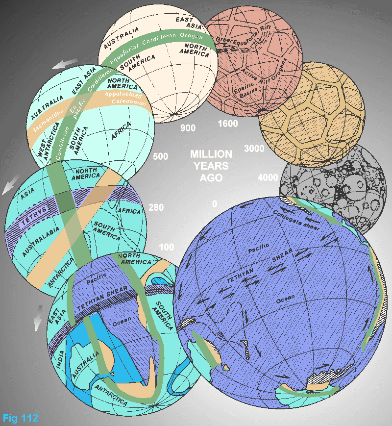 |
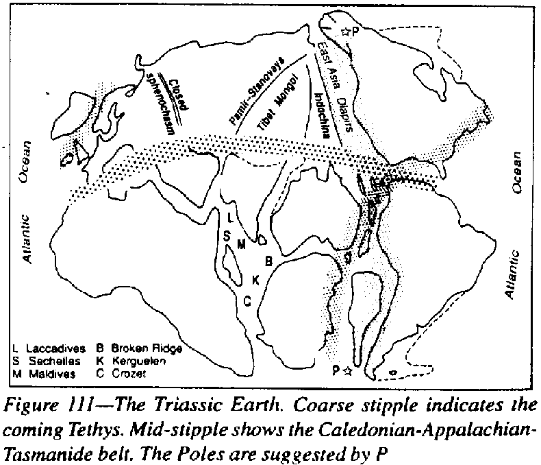
Expansion of the Earth has been most rapid during the last twentieth of geologic time! Certainly diapiric orogenesis is apparent in the oldest rocks we can study. Quite small bodies of the solar system show tensional fracture patterns. But the rate of expansion has accelerated. Figure 111 is a sketch of the whole Earth at the end of the Paleozoic. It wraps around so that the Americas adjoin Africa and Greenland. Neither the Pacific nor Atlantic Oceans existed at this time. All ocean floor that ever was, still is!
At the root of reluctance of geologists to embrace Earth expansion is the fundamental creed that folding, nappes, and orogenesis are compressional, which indicates regional contraction of the lithosphere. I have demonstrated in Chapter 2 that the visible contraction is secondary to primary diapirism. It is a matter of chance that the compressional concept was born in Britain while the diapiric model surfaced in Italy. Many Italian, German, and Russian geologists through the centuries have demonstrated theoretically and with dimensionally valid modelling that primary diapirism produces all the structural phenomena observed in the field - particularly La Paz in Italy, Reyer in Germany, Beloussov in Russia, Van Bemmelen in the Netherlands, and Ramberg in Sweden. None questioned the creed of constant Earth radius to realize that Earth expansion was implied. Beloussov recognized wider implications and introduced the oceanization concept which transformed anomalous sialic crust into sima. Americans revived the old German Einschluckung model, renaming it subduction. The numerical and financial might and arrogance of the English-speaking establishment has overwhelmed and dominated the Europeans.
A second reason for [geologists] doubt is the cause. It is absurd to deny tangible data because we do not yet know why things are so. Was Earth's density much greater in the past? I see no evidence of that, but I do find a consistent pattern throughout the solar system, and there is Hubble's clear evidence that the whole Universe is expanding, notwithstanding Newton's Law to the contrary. So the problem is cosmological - still a realm of wide speculation.
A third barrier is the increasing compartmentalism of science during the past century. Thousands of scientists work assiduously at the minutiae of their own discipline and switch off when a problem extends into the domain of others. Their own problem is swept under the mat. Let the tailor stick to his needle! No boundaries divide science. The compartments are human fictions. The generalists of yesteryear are no more. Darwin was trained inter alia as a physician; his letters to Lyell indicate that geology became his prime interest; his fame rests on his biology and theology.