Christianity to Ireland the pagan inhabitants of this place gathered to celebrate their religious festivals Teamhar (Taur) Luachra, known now as Taur Hill.
The myths and legends of this area included stories of Fionn and the Fianna, bands of legendary heroes and god-like men who hunted the stag and the fawn in the wooded slopes and glens. In later times this area formed part of the barony of Duhallow and these same woods and hills provided refuge for people hunted by invading English forces, for this was Clanawley, the land of the MacAuliffes, known also as 'MacAuliffe's dark mountains.'
The words of the verse above were written by the Irish poet O'Heeran in about 1400 A.D. In older times that part of the Blackwater between the Allow River and the town of Mallow was also known as the Eala or Allow; the surrounding country, roughly corresponding with the present barony of Duhallow, was called Eala. Glen Celsian is thought to have been the glen of the Dalua, where the MacAuliffes had a castle. The chieftain of the clan bore the title MacAmhlaoibh Eala or MacAuliffe of Duhallow.
The lands occupied by the MacAuliffes were known as Clanawley (in old references the name MacAuliffe is variously spelt, sometimes appearing as Awliff, Awly or Awley, with or without the 'Mac"). Literally, Clanawley means the tribe (clan) of Auliffe (Awley). More rarely, it was also known as Clanauliffe. In Clanawley still linger many of the old customs and traditions and until relatively recent times there could still be found here people from an older generation who could speak the Irish language. Here the people remained unaffected by foreign influences for longer than in most other parts of Ireland. In Clanawley the MacAuliffe chieftains ruled as princes until finally submerged by the English tide about the time of the battle of Kinsale.

Click image to read the ancient McAuliffe clan legends, in story, and in the verses by Edward Walsh, the Poet of Duhallow

Links to Irish history and culture, genealogy, Irish interest sites
Leave a message or read messages from others seeking clan information, searching for relatives, etc.

The webmaster would appreciate being advised of any broken links you find while viewing any of these pages
Hit counter restarted 10 June 2006
If you haven't already done so, please take a moment or two to sign the Guestbook?


Won't you please take a moment or two to sign the Guestbook?
on the McAuliffe Discussion Forum
Where the webmaster offers opinions on matters affecting the clan

Don't like the music? Turn
it off here or play it again
The openiing tune is 'Carrigfergus'
This and most other midi tunes
on this site were sequenced by Barry Taylor


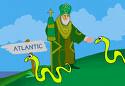
While Saint Patrick is credited with driving the snakes out of Ireland, the fact is that there were none there to drive out., at least not in the last 1.8 million years. Some sources beleve the story may have been a symbolic reference to pagans, who had a serpent as their emblem.
Check this fun card!

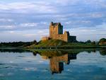
Irish castles worth visiting. Click image to see list


Site designed and maintained by Bob McAuliffe, Greymouth, New Zealand. This page last updated 30 January 2008
An Irish Quote
"The contest on our side is not one of rivalry or vengeance, but of endurance. It is not those who can inflict the most, but those who can suffer the most who will conquer".
Inaugural speech of Cork Mayor Terence MacSwiney who died on hunger strike, October 25, 1920.


So I don't have any yet, but when I do I'll have somewhere to put them.


"Far beyond the bountiful Allo,
and westward of Glen Celsian
of the stately trees,
in a fair land of great prosperity,
it is the Domain of the
noble Macauliffe"

n the north-west corner of County Cork lies a vast area of land, mostly hill-country, which stretches from the plain of the Blackwater River into the summits of the Mullaghareirk Mountains. This land was part of the famed Slieve Luachra of Ireland' mystical past. Long before Saint Patrick brought

Map of Munster province showing counties.
The arrow points to Clanawley.
BOUNDARIES OF CLANAWLEY
Clanawley extended roughly from the Allow River in the east to the Kerry border in the west and from the Limerick border to the Brogeen River in the south. While determining the actual boundaries is not easy, the Downe Survey, carried out about three hundred years ago, and the maps which accompany it, provide some guidance. Reference can also be made to another document - an official inquiry into the lands of the MacAuliffes, dated 25th January, 1615. Using the information provided in these documents, D.H Allen described what is probably a fairly accurate outline of the MacAuliffe territory.
'Beginning at Guiney's Bridge, the boundary of Clanawley followed the Cork - Limerick border to the River Allow, along which it travelled to a point about a mile east of Ballinaguillia Bridge. From there it turned south toward Knockawillin, taking in Knockskehy and Toorard on the way. There it linked up with the Coolageela glasha, continuing southwards by the creamery at Grillough, to the west of Bawnmore. Before reaching Coolageela the boundary turned west and crossed the ridge above Kilcorcoran graveyard to take in the townlands of Lisheeenowen and Gardeen. Underneath Rosline it joined the Owenarra River with which it ran to Ballydrohane where it turned, with the River Dalua, towards Kanturk. Within sight of the town it turned southwards, taking in Greenfield and Lismeelcunnin, to join the Brogeen River a mile and a half above the Old Court.
From there the boundary went west against the Brogeen, leaving it for a short distance to curve round the townland of Clongeel, which then belonged to MacDonagh MacCarthys of Kanturk. From the source it fell to the Araglin River in the neighbourhood of Dromskarragh. From this point, according to the inquiry document, the boundary continued toward the west to the Blackwater, which it reached just south of Ballydesmond. Then it proceeded along the present Cork - Kerry border to the Braonagh River, along which it ran to join the Feale, and so returned to Guiney's Bridge.
On the other hand, the Downe Survey map shows that the boundary went north from Dromskarragh along the Araglin River towards Glountanefinnane, and thence to the Blackwater to the north of Ballydesmond. This would mean a difference of several thousand acres from that claimed by the MacAuliffes in 1615, and also shows that this was an area of rival claims between the MacAuliffes and their neighbours to the west - the O'Keeffes.
One can realise the great stretch of country ruled by the MacAuliffes, over 80,000 acres; mixed land, no doubt, but still a land worth fighting for. Today, within its limits are such places as the town of Newmarket, Meelin, Rockchapel, Kiskeam, Lismire, and possibly Ballydesmond.'
DIVISIONS OF CLANAWLEY
Allen records that the Inquiry document of 1615 shows that Clanawley was divided into six parts - Drominarrigle, Castlemacauliffe, Aghatrasney, Carrigcashel, and two smaller parts, Coolavota in the east, and Lismeelcunnin between the Dalua and the Brogeen.
Irish clans were divided into smaller sections called septs, each of which had a part of the clan lands for its use. The precise description of these six divisions in the Inquiry document might suggest that the there were six MacAuliffes septs but no other evidence for that has been found. It is known, however, that there were at least two; one based at Castlemacauliffe and the other at Carrigcashel. The Castlemacauliffe sept was the leading one, from which the chieftain was usually chosen. The Carrigcashel sept became more prominent after the Battle of Kinsale and provided at least two chieftains for the clan.

Map: Divisions of Clanawley. Adapted from D.H Allen, 'The McAuliffes of Clanawley'. Areas in green were controlled by the Castlemacauliffe sept, the rest by another sept based at the castle of Carrigcashel. Clonfert, shown on the map, consisted of a village, church and cemetery and was the traditional burial-place of the McAuliffes. There was a church and village associated with the castle at Carrigcashel, and also at Anacrohane (modern-day Newmarket).


Much of the material fort this page has come from D.H Allen, 'The McAuliffes of Clanawley", 1991.
Map shows boundaries ofancient Clanawley with some present-day towns marked in.

