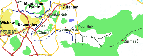
Location of Bonkle
Origins and the Name Bonkle

Auchter House (1886).
This sits at the junction of the Calder and Auchter rivers with steep
banks giving it a defensive position. It is built on the earlier
settlements of Dunaninbher (the height, or fort, above the meeting of the
waters) and Auchter Bridgend.
Bonkle (often pronounced bUnkle after an earlier spelling) derives its
name from a Norman knight who built Buncle Castle, near Duns,
Berwickshire. His decendant, Margaret, married John Steuart of Daldowie
and Allanton in 1288. They built their house near Bonkle and Margaret's
name was retained in the village name. The suggested derivations of the
name are -
Bon Cella - excellent site for granary.
Bonchoille or Bon Coile - (the hollow at) the foot of the wood.
Bon Cill - Chapel at the foot of the ridge.
Many of the names in the area derive from a skirmish involving Allan
Steuart
Cathkers - The field east of the battle.
Alcath . - The field of Allan's battle.
Cath Burn- The battle burn
Auchter Water The river of Allan's battle.
Mornside The place to the morning side (east) of the battle
(actually the battle was to the west).
Return to Contents
Growth of Bonkle Village

The village was originally built on grounds of Allanton house, but the estate was split up and sold in 1932 and the house later demolished. The other large estate of murdostoun has also been split up and sold but Murdostoun Castle still remains as a nursing home.
Bonkle Smiddy
 The horse was used for transport as well as working the land so a
blacksmith's shop was essential in the area. Even when tractors became
available the smith remained as a repair and welding shop to maintain the
farm machinery.
The horse was used for transport as well as working the land so a
blacksmith's shop was essential in the area. Even when tractors became
available the smith remained as a repair and welding shop to maintain the
farm machinery.
 The "Main Street" - Church Road, Bonkle.
The existing houses just visible on the right were built around 1785 and
the layout, including the trees, has remained almost unaltered.

ThePillars
The ground on which Bonkle stands, including Allanton Road, belonged to the Steuarts' of Allanton.
No 1 Church Road, built in 1811, was originally the toll house for
traffic passing through Allanton Estate.
On the left, No. 3 Allanton Road (+ 5 and 7) were built in 1817, about the time of the battle of Waterloo, and became known as the "Waterloo Cottages". They were built by the Brownlee family. Two of the Brownlee brothers later walked from Bonkle to Greenock and boarded ship for New York where they are reputed to have built the first skyscraper. They then continued to Arkansas where they built the Municipal Buildings.
No. 9 Allanton Road - "Whitebanks" - was built arround 1850 to look like a cottage but is more the size of a small castle. A coach house and stables were added at a later date. The name possbily was given because of the wild garlic growing on the banks of the River Calder which runs just behind the house.
These buildings, plus 2 Allanton Road and 2 and 4 Church road are listed buildings.
Bonkle, 1998

In the 1920s the council housing of Meadowfield Place (front, left) was built. The private housing schemes of Brownhill View (centre) was added in 1966 and and Cairney Place (right, top) in the 1980s. The older houses are hidden behind the trees in front of the church.
Growth of the Church
Covenanters
 In 1638 and 1641 the National Covenant and Solemn League was designed to
protect the civil and religeous liberties of Scotland and England. This
did not find favour with Stuart kings and Charles II imposed the episcopal
form of worship. The persecution that followed forced covenanters to
worship at open air Conventicles, such as Darmead Linn. (The memorial
shown was built in 1836) The memorials of Starryshaws and The Peden Stane
(both between Shotts and Harthill) are also nearby.
In 1638 and 1641 the National Covenant and Solemn League was designed to
protect the civil and religeous liberties of Scotland and England. This
did not find favour with Stuart kings and Charles II imposed the episcopal
form of worship. The persecution that followed forced covenanters to
worship at open air Conventicles, such as Darmead Linn. (The memorial
shown was built in 1836) The memorials of Starryshaws and The Peden Stane
(both between Shotts and Harthill) are also nearby.
James Renwick was hung in 1689 for such activities.
In 1688 the revolution overthrew the last of the Stewart kings, James II.
Under William and Mary Presbyterianism was restored in Scotland and the
Revolution Settlement followed in 1690. This did not bring complete peace
as the free choice of minister by the congregation was not adhered to.
This, and differences in doctrine, led to the Secession church forming
under Ebinezer Erskine.

Ruins of the Moor Kirk
Daviesdykes, near Allanton, sometimes referred to as "Durie (Dura)
Kirk". This was the second building on this site. The original had a
turf roof giving it the nickname of "The Heather Kirk"
Mr Lockhart of Cambusnethan Manor presented Mr Craig as minister of Cambusnethan Church. A large number of the congregation objected to this and, after a long running dispute, formed a prayer group. They then applied to the infant Secession Church for sermon, the congregation being officially recognised in 1737. The church was opened in 1740 and rebuilt in 1780 with a slate roof.
On to Bonkle
 The congregation moved to Bonkle in 1818, a severe barn-like church being
built to seat 560 people. In 1872 the West wall had to be supported by
wooden stays so rebuilding was required. In 1878 the kirk was closed,
demolished and rebuilt
The congregation moved to Bonkle in 1818, a severe barn-like church being
built to seat 560 people. In 1872 the West wall had to be supported by
wooden stays so rebuilding was required. In 1878 the kirk was closed,
demolished and rebuilt
The hall was added in 1880.

The present church was built in 1878 to a simple Gothic style using honey coloured sandstone.

The interior of the church contains a raised pulpit on the south wall with a balcony on the remaining three walls. A visiting preacher said "you feel as if, from the pulpit, you could reach out and touch everyone in the congregation", so compact is the layout. Above the pulpit are three large stain-glass windows with another two commemorative windows on the west wall.
Allanton Church was transferred to the charge of Calderhead Church in 1964
When Rev. G. McMillan retired in 1970 the Presbytery placed a restriction on the call to a new minister who must be aged 55 or over. Rev. R. Campbell was appointed.
In December 1973 a severe spell of cold weather caused failure of the heating and destroyed the entire system, which had to be replaced.
 When Rev. Campbell retired in 1978 due to ill health, Bonkle was not
allowed to call a minister. After lengthy discussions with Allanton,
Morningside and Coltness Churches it was decided to link Bonkle to
Coltness, which had also become vacant. In 1980 the churches called Rev.
Wm Frame to the linked charge.
When Rev. Campbell retired in 1978 due to ill health, Bonkle was not
allowed to call a minister. After lengthy discussions with Allanton,
Morningside and Coltness Churches it was decided to link Bonkle to
Coltness, which had also become vacant. In 1980 the churches called Rev.
Wm Frame to the linked charge.
A new additional hall was built in 1991.
Farming
 Higher Daviesdykes farmhouse)
The land in the area is fairly high - 500 to 1050 ft - and mainly heavy
clay soil. The upper land is mainly heather covered (now Kingshill
forest). The main estate owners were the Steuarts of Allanton who used
this as a "Grouse Moor".
A nick-name for the Moor Kirk was The Kirk of the Buchts due to
the large number of sheepfolds in the area.
The lower land is likely to have been cultivated for many centuries.
The area was much more heavily populated than it is today, small groups
of houses being scattered throughout the area. In 1890, 950 people lived
on Auchterhead Muir.
Rural trades - carpentry, weaving, milling (at Allanton one mill
remains), and blacksmiths (at Bonkle and Allanton, now houses.)
 In 1932 Allanton Estate was split up and sold, part of the land being
bought by the Department of Agriculture who divided Sharnotshields and
Cathburn farms into "Small Holdings" of about 10 acres each.
Some crops were grown, mainly potatoes and oats, and a few had some cows
or goats. The small acreage forced more intensive farming such as pigs,
poultry and egg production. Many smallholders had another occupation. The
war and mechanisation forced the recombination of the land into more
economic units. Dairy and beef cattle, sheep, and the associated
production of silage and barley are now the main farm produce.
In 1932 Allanton Estate was split up and sold, part of the land being
bought by the Department of Agriculture who divided Sharnotshields and
Cathburn farms into "Small Holdings" of about 10 acres each.
Some crops were grown, mainly potatoes and oats, and a few had some cows
or goats. The small acreage forced more intensive farming such as pigs,
poultry and egg production. Many smallholders had another occupation. The
war and mechanisation forced the recombination of the land into more
economic units. Dairy and beef cattle, sheep, and the associated
production of silage and barley are now the main farm produce.
More farms are now being bought up for afforestation and open cast coal
mining.
Industry
The statistical survey of 1793 found large quantities of coal and
blackband ironstone in the area. This led to the rapid growth of mining
and the creation of blast furnaces at Shotts in 1802 followed by furnaces
- 9 in total - at Newmains in 1839. Squares of houses were built for the
workers - now largely gone. Shotts had a population of 18,000
Brickworks, tile works and a cement work were also constructed in the
area (all now closed).
In the middle of the 20th centuary the iron and steel industry tended to
concentrate in the Motherwell area culminating in 1957 with the
construction of the large integrated steelplant of Ravenscraig.
The coal industry was nationalised in 1945 and the last blast furnace in
Newmains closed in 1927 and Shotts in 1947. The last coal pit - Calderhead
Training Centre - closed in 1984. Ravenscraig closed in 1992, ending the
dominance of heavy industry in the area.
Some open cast mining still takes place.
References
1) "The first 250 years of Bonkle Congregation" - Booklet by
Miss Jessie G. Brown, Elder.
2) Wishaw Press, Sept - Oct 1937 Sermons by Rev. Winchester to
commemorate 200th anniversary
3) Notes left by Sandy McIntyre, a copy of which is held in Motherwell
Heritage Centre.
4) Shotts Heritage Centre, Shotts library Motherwell Heritage Centre,
history section.
5) The Scottish Covenanters - James Barr, B.D.- John Smith and Sons, 1946
- L/274.
6) History of Shotts - Crossart - Aird and Coghill - 1880 7) Historical
Sketches of the Parish of Cambusnethan - Rev. Peter Brown - David Johnston
1859 - L9411/43(cam)
Some of the quoted material can be found in the website of
www.bonkle.org.uk which also
contains contacts and links for Bonkle Church and Local Organisations.