CHAPTER 7: SETTLEMENT, ARTIFACTS AND THE
TRANSITION TO ANGLO-SAXON ENGLAND
INTRODUCTION
The preceding chapters, in their different ways, have presented us with details of cemeteries, artifacts and place-names in the region. The Gazetteers and Catalogues in Volume 2 present the data from public and accessible private sources. What I am attempting to achieve in this final chapter is a synthesis of these data. In the discussion which follows several assumptions are made. One is due to the disparity of the evidence from Roman and from Anglo-Saxon material. When one speaks of a Roman occupation site, its location is, on the whole, known. With few exceptions, however, the Anglo-Saxon settlements are known solely from their cemeteries and it has to be assumed that where there are cemeteries, the settlements are situated not far away (compare Davies and Vierck, 1974, 259-271). It seems most plausible that the cemeteries were within 2-5 miles at most from the settlements not least for convenience in carrying the corpse; in addition, the comparatively small size of the majority of burial places suggests a reasonably small catchment area and so proximity to the dwellings. It has also been assumed that where there is a Romano-British site nearby, this was the earlier settlement and that the Anglo-Saxons arrived at a later date: however, in view of the continued uncertainty in the dating of the earliest Anglo-Saxon pottery, and the possibility that some of the plainer Roman material (Signal Station ware or Derby Dalesware Types) continued into the fifth century, it is by no means certain that this was always the case. Some sites may not have been occupied continuously but where the Romano-British and Anglo-Saxon finds are associated, the site was probably favourable to both groups. It is interesting to note when examining the maps how close is the proximity of Anglo-Saxon settlements and Romano-British sites. It is also interesting to note whether these settlements shared a common burial site, a common place-name form or an early recorded name.
SETTLEMENT PATTERNS
The great majority of pagan sites are located in the neighbourhood of Roman settlements, but some of them were apparently abandoned many decades before the arrival of the Anglo-Saxons. The abandonment of the sites may be an illusion. The Romano-British settlements were probably shifting from location to location as were some of the Anglo-Saxon ones. It appears increasingly likely, as the distribution patterns of the two peoples become better known, that the immigrants seldom settled in a wilderness of regenerated woodland. Some movement of the Romano-British population in this region (as implied by Gildas) is possible. If so, it is likely that it was the land-owning class that was principally represented. The flight of the whole population, once so firmly believed in, seems most improbable. In consequence, the coloni and bondsmen are likely to have remained behind. Untrained to bear arms, these peasants would have accepted the immigrants as their new masters, who would take over the land that had not ceased to be ploughed. They probably also took over the seed-corn, the bread-corn, the implements and farm-beasts at the same time.
SETTLEMENTS AND BURIALS
This suggests that the burial sites are the earliest settlement pattern of the Anglo-Saxons in England. In particular, the burial sites are found more frequently in conjunction or association with the Romano-British sites, much more so than any other evidenced Anglo-Saxon settlements. This conjunction argues that the cemeteries are of an early date.
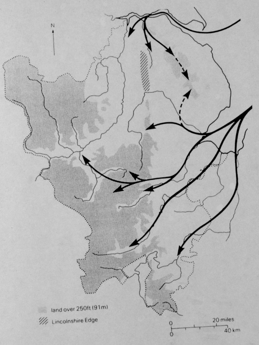
Figure 16 Routes of Immigration from P. Stafford, 1985.
A factor which emerges is that while the known Anglo-Saxon settlements themselves were rarely on the Roman roads, many of the cemetery and burial sites were located on or near the roads. This re-emphasises their association with the Romano-British and also that the place-names may reflect not the first settlement phase but later colonisation. Immigrants landing in Lincolnshire around in the area of Skegness might have come across the Roman road running westwards to Lincoln but some of them did not proceed far along it as the burials at Burgh-le-Marsh, Partney and Candlesby show. Further inland along the same road, only two sites are known to indicate settlement that might be related to the road. The settlements lie away from the main roads, perhaps because it was safer to live off the main roads, out of the way of bandits. But note that in this region the roads were mainly on the high ground and not in the lowland where the land was good for farming. Late occupation within towns is likely. From soil above the late layers at Ancaster and Margidunum, pottery of coarse grey-brown fabric now in Nottingham University Museum suggests continued settlement here into the fifth century and beyond. But this evidence is rare and the lack of archaeological material seems to be against the idea of large-scale continuity in the settlements. The excavated villa sites of eastern England provide very little evidence for continuity of settlement (Todd, 1991, 136). At Southwell, Nottinghamshire, the Anglo-Saxons moved in after the Romano-British had abandoned the site and at Denton, Lincolnshire, the villa was used for Anglo-Saxon burials, one of the graves cut into the centre of a late Roman mosaic (Stafford, 1985, 90). The archaeological record however is not very complete so no firm conclusions can be made. Also, both the Romano-British and the Anglo-Saxons may have moved away from villa sites. Settlement sites and patterns, as opposed to villa occupation, show no clear break during the fifth and sixth centuries. The great disparity in the number of known settlement sites compared with burial sites is largely due to the much slighter traces of domestic occupation. Burials when disturbed are usually obvious. They were first found in very large numbers before settlements were first recognized in the 1920s. Since then it is likely that occupation sites were disturbed but not recognized for what they were.
The evidence from both burials and settlements suggests that the majority of them had a small population. Even large cemeteries that continued in use for 200 years would have served a modest population. The larger settlements usually include much rebuilding where it is possible to determine how many buildings were in use at the same time, the "large" settlement proves to have been not much more than a few farms grouped together: compare, for example the phases (4 or 5) at Catholme (G. Kinsley, pers. comm.), where over 70 structures represent no more than a dozen buildings of all types-houses, byres and stores-in use at any one time. Small settlements had neither the manpower or the need to cultivated large areas. A few acres of good land in an area of moderate fertility would have been enough and it could well be that the fields were left to fallow for several years and tillage moved around.
SETTLEMENT AND HOUSES
Not many villages and peasant dwellings have been excavated in this region. The Continental villages of the migration period contained large three-aisled halls or longhouses with ancillary buildings. Few of these have been found in the early English settlements and it has even been suggested that the plan of the typical Anglo-Saxon houses belong to a Romano-British rather than Germanic tradition (Dixon, 1982, 278; Millet, 1984, 205-206). In our region only Catholme, a cluster of farm houses ranging from the fifth/sixth centuries to the ninth century, can be seen as a large excavated hamlet. Elsewhere no more than sunken-floored huts, like those at Salmonby, Lincolnshire, are found with their floors often covered in accumulated rubbish (Everson, 1973, 61-69). These squalid structures give the impression that the early Anglo-Saxon settlers were poor squatters. But many sunken-floored pits were later used as rubbish pits and their accumulations of rubbish may not indicate squalid habits of their former owners but rather the infill after the site was abandoned.
Knowledge of town dwellings is growing rapidly with the careful excavation of sites such as Flaxengate in Lincoln (Perring, 1981), or, outside the region, York (Coppergate) and Dublin. Construction techniques here were similar to those in rural areas. Overlapping or abutting horizontal boards or planks were attached to posts set directly into the ground. The houses were of a single story with a centrally placed hearth, though there is some evidence for internal partitioning and a cross passage joining opposite doors. The floors were of beaten earth, clay or grassy material such as straw or brushwood, though the disappearance of planked floors over the centuries may give too simple a picture. The life expectancy of these buildings, subject especially to the rotting of posts and fire, was very low; in some cases as little as five years, with most probably unstable within 15 to 20 years. Fire was a common hazard. Almost all the building constructed on the Flaxengate site before around 1040 showed signs of fire destruction, in some cases possibly even a deliberate prelude to rebuilding.
MOVEMENTS
What may have started as a controlled movement of mercenaries employed by the Romano-British had apparently passed out of their hands by the late fifth century. The very earliest Anglo-Saxon cemeteries in this area show a slightly later start than claimed by Myres for the East Anglian sites at Caistor and Markshall (Myres, 1973, 46). Apart from a handful of material from Hibaldstow, Kirmington and Elsham, all in Lincolnshire, little or nothing need be much earlier than the middle of the fifth century, with developed Aberg Group I cruciforms as the clearest sign of date. From this period onwards there are clear signs of continuity. Several, such as Kirton-in-Lindsey, Lincolnshire, show an increase in size in the later fifth and the early sixth centuries. The rapid expansion of the Anglo-Saxons can be seen by the cemeteries like those at South Elkington, Fonaby near Caistor, and Hall Hill, West Keal, Lincolnshire (Eagles, 1980, 285-287) in which sixth century material is plentiful. During this period new cemeteries are to be found along the North Sea routes and the river valleys. The picture of a major shift of settlement in the late fifth century and sixth century parallels the expansion of the Rhenish tribes westwards from c.480.
Gildas's story suggests that it was the larger groups of the Germanic mercenaries who settled in eastern England and whose rebellion and reinforcement led to the eventual Anglo-Saxon take-over. This may well have occurred in the middle of the century. The actual settlement of England, however, was later. This large-scale migration seems to belong to the late fifth or early sixth centuries. From the first half of the fifth century there is some evidence that Germanic groups were defending important communication routes such as the River Humber and the Ancaster Gap and they are also associated with important Romano-British sites. At Great Casterton, Leicestershire, a group of pagan burials have been found in the bank of the Roman town. At Ancaster, Lincolnshire, a pagan cremation cemetery lies just outside the south face of the Roman defense (Hawkes, 1946a, 89-90). And in north Lincolnshire, the cemetery of Kirton-in-Lindsey may date to before 450 (Eagles, 1980, 285-287). The siting of these burials may suggest a deliberate employment by the Romano-British but there is some doubt to this. Even the close association of Anglo-Saxon and Romano-British occupation does not prove coexistence or deliberate employment. At Vernemetum, early Anglo-Saxon burials overlie Roman buildings (Whitwell, 1982, 158). This argues that there was a possible time-lag between the two periods at this site.
The "Angles" and "Saxons" who arrived in the East Midlands in the fifth and sixth centuries probably came from north Germany and Frisia. On the Continent, "Angles" and "Saxons" may have been distinct groups and were recognizable by their material culture. The Angles preferred bow or cruciform brooches and sets of miniature objects, the Saxons preferred round brooches and narrow-necked decorated pots. But these distinctions, which were cultural rather than ethnic, had disappeared by the time of the Frisian Continental cemeteries like Issendorf, which were contemporary with the English settlements. The cemeteries of eastern England show this mixture of styles in pottery and other artifacts. It is clear that the settlers had combined culturally in Frisia before their arrival and that they do not fall into clear groups of Angles or Saxons when they arrived.
It is through their cemeteries that these settlers can be studied. Over 1000 cemeteries have been recorded in England and a majority of them are in the east. There are concentrations of Anglo-Saxon cemeteries in Lincolnshire and Leicestershire. The first impression we get is that of a large scale population movement into eastern England. This impression fits the geography of the region and the evidence of Gildas and Henry of Huntingdon. These cemeteries are evidence of Anglo-Saxon communities in the area and it is possible that they contained a large number of Britons because all ethnic differences may well have been put aside at death (Arnold, 1984, 129). Cemeteries like Thurmaston, Leicestershire, Elsham, Loveden Hill, Sleaford, and South Elkington, Lincolnshire and Newark, Nottinghamshire were cremation cemeteries in the sixth century and possibly earlier. There is little evidence for the survival of British or Christian burial rites at these cemeteries, as is found in the early Anglo-Saxon cemeteries of Yorkshire (Faull, 1977, 5-7). In life and in death the inhabitants of these cemeteries were non-Christians which was a new religious group in England. The British population survived here and were probably buried in separate cemeteries or were so completely dominated by the new Anglo-Saxon culture that they changed their religious and social habits to fit in. The Anglo-Saxon communities kept their own pagan culture long after their first arrival in the area.
The Anglo-Saxons were probably not searching for virgin land for settlement. In the valleys of the Welland and the Nene, the Anglo-Saxons were moving into areas that were already settled. The gravel terraces of these river valleys had supported a high population since the prehistoric period. There is not much evidence for significant change in the settlement pattern of this area. If anything, the pattern which the Romans followed reasserted itself. A line of early village names in Lincolnshire does not seem to be associated with the artificial line of the Roman road from Lincoln, the Ermine Street, but may be associated with the prehistoric track and the spring-line sites which were favoured by earlier settlers. Continuity of sites rather than new settlement and reorganization seems to have been the norm.
A similar pattern emerges in the Trent valley, where the Anglo-Saxon arrival was late. The settlement of this area belongs to the sixth century rather than the earliest stages of settlement in the late fifth century. Movement into the Trent valley and its major tributaries was in two directions; some penetration may have been from the north down the Trent itself, so that Newark would have been an outpost of this movement but most of the movement probably came from the east through the Wash rivers like the River Welland into Rutland and east Leicestershire and the River Soar, especially around the plateau around Tilton, Lincolnshire, and then into the middle Trent valley (Fowler, 1954, 134-138; Meaney, 1964, 14; Clough, Dornier, Rutland, 1975, 12-13; Myres, 1986, 76-77). The Middle Trent valley is an area with numerous pagan Anglo-Saxon cemeteries, not only cremation cemeteries but also several of mixed cemeteries and a number of inhumation cemeteries as well. They stretch from Newark, Holme Pierrepoint and Cotgrave, Nottinghamshire in the east to Kingston-upon-Soar, Nottinghamshire and Melbourne and Hilton, Derbyshire in the centre and then to Caves Inn, Leicestershire. Early place-names like Empingham, Collingham, and Nottingham have a similar pattern. These are areas of existing settlement: the plateau around Tilton, for example, was a nucleus of pre-Roman settlement. The picture of Anglo-Saxons, rowing up the rivers to find desirable virgin land turns into one of settlers drawn to existing areas of settlement which were already established on the most fertile soil. Unfortunately, the River Trent cuts through the modern and medieval administrative boundaries-of counties and municipalities-which determined the establishment of museums and archaeological societies in Victorian times and more recently of archaeological units. As a result, the Trent valley cemeteries have never been studied as a group. The work that has been done suggests that these proto-Mercian settlements were relatively small, relatively late (beginning in the sixth century rather than the fifth) and relatively poor.
BURIALS
This does not mean that there were a large number of settlers. Settlements of foederati such as around Lincoln may have retained their culture as a distinguishing characteristic and may have achieved a greater coherence in relation to surrounding communities. Evidence of this is found in the artifacts that have been found in Lincoln namely the wide-mouthed urn found in 1887 that is similar to ones found in Borgstedt and Beetgum, Holland and the coin of Arcadius and buckle of Germanic origin found at the Roman gateway. But the Anglo-Saxon settlers cannot be seen as just a new and small aristocratic group. There are not the cemeteries in the East Midlands to match the size of the "migration period" cemeteries across the North Sea. Some of the cemeteries, like Westerwanna, have over 4000 burials. An estimate of the total size of Loveden Hill, Lincolnshire has placed it at about 2000 burials. This is well short of the Continental cemeteries but it does to show that it was not a small group of aristocratic overlords settling in Britain. Incomplete excavations make it very difficult to know the real size of other cemeteries like Elsham with around 600 urns or Newark with around 200 urns. A cemetery like Loveden Hill was in continual use for over 200 years and may have served several communities or may have been a cemetery for one very important community presumably on or near the site of medieval Sleaford below the cemetery; we can not be sure because of the lack of information on the site. The area displays its early importance by the presence of the late Iron Age and Romano-British Oppidum of Old Sleaford, a major tribal centre of the Corieltauvi (S. Elsdon, pers. inf.). The small cremation cemetery of Old Sleaford may have been in use at the same time as Loveden Hill. It seems to have been placed away from settlements, on high land overlooking the Witham valley between Grantham and Newark. Estimates of its size come from the early cremation section and it is the nature of the finds of such cemeteries which argue against a simple aristocratic settlement of the East Midlands. The earliest cremation cemeteries suggest that there was a contrast between a handful of wealthy individuals and a poorer majority. The lack of grave goods may mean many things apart from material poverty in life but it is difficult to see the bodies buried at Loveden Hill as those of an aristocratic group with their bones bearing signs of heavy labour and premature ageing (Wilkinson, 1980, 221-231). The communal nature of some cemeteries and their use over a long period means that they cannot be used to argue the size of the local Anglo-Saxon population. Also, they cannot tell us about the Britons, who may or may not have been buried in them. But they do tell us that the Anglo-Saxon settlement of the East Midlands consisted of both aristocrats and peasant farmers.
ARTIFACTS
Where grave goods are found, their distribution between sexes and ages is significant in a society where the possession of certain objects mark status, rank and participation in social life (Pader, 1980, 155-156). In the sixth and seventh century cemeteries, military equipment such as shields, spears, helmets and swords, mark out adult male graves. At Bowers Low, Derbyshire a rich male grave of the seventh century was equipped with shield, iron spear and a 34 inch sword with an ornamental sheath (See Gazetteer, 3). The spear was standard equipment of the adult male of these early centuries (Hills, 1979, 321). The culture was primarily militaristic, as the poetry and annals show, but the widespread possession of weapons, especially in the early centuries, does not suggest a violent society but one in which military objects were used as indicators of status in life. Possession of a spear and a shield showed that a man was an adult capable of taking part in social life, a part which might include war. As late as the tenth century the possession of weapons was the mark and proof of freedom, of the right to take part in the local courts (Brooks, 1978, 82-83). Such symbols were formally handed over at the age of maturity. Possession of them presumably marks the sixth and seventh century men buried in the Anglo-Saxon cemeteries as free, and adult. Compare this possession of weapons in the sixth and seventh century with the taking of weapons from King Conchubor by Chu Chulainn in the Tain Bo' Cuihgne (O'Rahilly, 1967, lines 940 and following)
There is no object or objects regularly associated with adult women which could have held any similar significance. There was apparently no comparable female transition to a full role in the community. The graves of women and children often show similarities in grave goods (Pader, 1980, 155-156). In terms of the community and the formal part they could play in it, women and children were probably considered minors and were under the control of the men in the community. Instead, women's grave goods vary enormously, often being the richest in the early cemeteries (Arnold, 1980, 120). From the fifth to the seventh centuries women were buried with an assortment of knives, beads, brooches, rings, spoons, crystal balls and so on. At Cow Low, Derbyshire a female body was buried with gold pins set with garnets, a wooden box, green glass vessel, ivory comb, needles, iron instruments and necklace. At least until the seventh century, when rich male burials become more important, it is in female graves that the most ostentatious wealth is found. Not all women's graves are rich however. The families of early Anglo-Saxon England indicated their wealth and status most openly on their womenfolk by decking them out in death.
The earliest cemeteries of the fifth and sixth centuries suggest a general level of relative poverty contrasted with a few wealthy groups. This is based on the poverty of grave goods which is the norm at places like South Elkington. At this site, many bodies were buried with few grave goods or with only a handful of beads and only one grave showed pretensions, surrounded by a ditch and containing a spearhead, knife, ironwork and pottery (See Gazetteer, 108-109). There are problems in interpreting these cemeteries since the absence of grave goods may indicate varied beliefs, elaborate pre-burial rituals and graves with few goods are difficult to date. But the contrasts stand out between the majority, buried with knives, beads, perhaps a spearhead, and a wealthy minority. At Loveden Hill, one cremation urn had been enclosed in a cist with two combs, a sword and a drinking horn and another was accompanied by two metal vessels, a cloth covered urn, a bucket, a drinking glass and a sword (Rahtz, Dickinson and Watts, 1980, 338). They are typical of rich sixth century male graves in which status is indicated not by a quantity of objects but by a small number of status symbols, especially military equipment like the sword, whose meaning was fully understood by contemporaries (Arnold, 1980, 132-134). The contrast with early women's graves, rich in quantity and quality of goods, has already been drawn.
The dress of the early inhabitants of the East Midlands can be reconstructed only tentatively and mainly from cemeteries. The dead were buried clothed and it is especially from the graves of the wealthy that some idea of clothing and adornments is gained. Garment fastenings, such as those manufactured in Lincoln at Flaxengate in the tenth century, seem unknown before the Viking arrival. Before this, garments were secured by a variety of pins, brooches and ribbons for both sexes. The jewellery found in so many early graves is an elaboration of basic, utilitarian necessities. Single brooches fastened cloaks at the shoulder, whilst pairs of brooches, with beads slung between them, could secure a cloak across the breast. Clasps of brooches gathered the sleeve at the wrist. Wealthy women of the pagan period were often buried with the chatelaine which hung from their girdles, including tweezers and cosmetic brushes, and with the bone combs with which they dressed their hair (Brown, 1974, 151-154). Wealthy men of the fifth and sixth centuries carried less ornamentation, though those who could afford it were buried with a buckled sword or knife belt hanging from the right shoulder.
It is only occasionally that the graves show a lighter, less utilitarian side of life. One skeleton at Tugby, Leicestershire, had been buried with bone dice and 46 discs, for playing a game similar to draughts and one of the cremations at Cold Eaton, Derbyshire was accompanied by 28 bone playing-pieces (See Gazetteer, 5; Clough, Dornier and Rutland, 1975, 14-15 and 73). They are an indication of some individual's view of the afterlife, if not of this life.
ARTIFACTS FROM THE FIFTH AND SIXTH CENTURIES
The cemeteries of the fifth and sixth centuries thus reveal a community with a comfortable as well as wealthy segment. The richer graves have complete sets of expensive weaponry, which we have come to associate with the nobility but many graves contained metal objects. At Loveden Hill, iron knives, bronze brooches, bronze tweezers and iron shears are relatively common and spears are widespread. Even South Elkington, generally considered a poor cemetery, yielded ironwork as well as beads (Eagles, 1980). Death called for display and more than a tiny minority of these earliest settlers could afford it.
ARTIFACTS FROM THE SEVENTH CENTURY
By the seventh century, social divisions in the grave goods are very evident. Wealthy graves were distinguished by rich furnishings, a number of prestige objects and elaborate barrows or cists constructed around them. Rich female graves are still well equipped but it is now their male counterparts which stand out. At Loveden Hill, the richest graves are usually the latest, one with a hanging bowl, sword and large bronze-bound decorated bucket (Fennell, 1974, 285-286). The seventh century woman buried at White Lowe, Derbyshire, had a gold cross and brooch, silver collar and glass vessels and at Galley Lowe, Derbyshire a woman was buried with a whetstone and 13 gold pendants, 11 set with garnets (See Gazetteer, 15-16). Gold is never again found in the quantity in which it occurs in these seventh century graves and it is tempting to see this burst of display as a pagan response to the then contemporary expansion of Christianity, with its novel introduction of a true after life. Fine swords are buried in increasing quantity at Horncastle and Kirton-in-Lindsey, Lincolnshire, and at Bowers Low, Derbyshire. The Benty Grange warrior burial is one of the most important seventh century finds of the area. Its occupant was buried with a silver ornamented leather cup, two enamelled bronze discs, fine wire and braiding attached to what was once a silk garment, a woollen cloak and a helmet. The iron ribs of that helmet were once covered with horn plates, fastened with silver rivets and mounted on its crown is a boar of bronze and silver gilt with eyes of garnet. On the nasal guard a silver cross indicated his Christian affiliation (See Gazetteer, 2).
ECONOMY
The domestic economy was based on wood and its disappearance in most soil conditions means that the archaeological picture of lifestyle is very incomplete. Cooking pots are the most regular find followed by bowls. The output of the pottery industry of a place like Stamford confirms this; cooking vessels, with and without lids, large bowls and spouted pitchers formed the bulk of production. Tableware was largely wooden with pottery used for cooking. The large cooking pots were designed for slow cooking placed in the ashes to simmer with skillets for higher temperature use (Kilmurry, 1980, 26-27). Plates and other flatware were not produced much and the predominance of bowls in the pottery tableware may indicate that porridge and stews were the predominant cooked diet. Even drinking vessels were mostly wood or leather. The few pottery ones made were often goblet-shaped in imitation of the high value metalware used only by the wealthy. Pottery copies of expensive metal objects occur from a very early period. In the seventh century, a bronze cauldron was buried in a rich grave to the south of Louth at Stenigot and pottery copies of these valuable objects have been found (Thompson, 1956b, 193). Wood was even used for chalices. Archbishop Wulfstan, as always attempting to regulate conduct, tried to outlaw them in his rules for the priests of his province since they posed problems of purification.
Metalwork played a small but important part of lifestyle. Craftsman-produced objects fashioned from it, especially weapons, which were the objects of status and prestige throughout the Anglo-Saxon period. It was sparingly used by the poor. Knives, pins, nails, more rarely weapons, were the only metal objects likely to be found in most households; the importance of the weapons brandished at the wapentake should not be underestimated. Metal was used especially for tools in agriculture or for woodwork, gradually coming into use for the iron plough share or fashioned into axes, adzes, chisels and planes.
The home production of textiles was a regular female task. Loom weights usually of pottery of unbaked clay are a common find since the loom was standard household equipment. It may have been a horizontal or a beam-tensioned loom since either would have involved the weighting of the warp threads in this way. Loom weights become rarer in late Saxon contexts. None were found at Flaxengate although this may merely indicate that spinning not weaving was carried out on the site (Mann, 1982, 43). Their absence may indicate the gradual spread of the two-beam vertical loom or the treadle-operated one, neither of which required the weighting of warp threads. Wool was the most common material, woven in plain weave or twill. Wool-braid was tablet-woven, and a rare example of it was found in the cemetery at Fonaby near Caistor, Lincolnshire (See Gazetteer, 83-84). Linen and silk were known, though imported silk marked out the princely, like the Benty Grange warrior. Linen, although prestigious, was more widely used. The role of even the most prosperous women in the domestic provision for their families was emphasized in death.
SITES IN DERBYSHIRE
Even though Derbyshire was an important area for the Romans, with Buxton as an important settlement, the archaeological evidence for the Anglo-Saxon period seems to be late. There is little or nothing dating before the seventh century barrows of Benty Grange, Borrowash or Cow Low, near Buxton (Ozanne, 1962-3, 32). There is evidence for strong Celtic survival in the Derbyshire Pennines by the survival of eccles place-names and other Celtic names like Mellor, Dinting, Tintwistle, Crich, Chevin and Mam Tor. But the Celtic place-names were not confined to the upland regions and Celtic river names are found throughout the area. It is a fact that the majority of our place-names are English and the few surviving Celtic names may indicate pockets of surviving Britons (Gelling, 1988a, 101). But the problems of assessing place-name changes has been discussed and no easy equation should be made between the disappearance of so many of the British names and the disappearance of the Britons themselves. The pagan cremation cemeteries in Derbyshire are found in the Trent basin at King's Newton and Drakelow. This suggests a later Anglo-Saxon movement into the remote and inhospitable region of the Peak. It has been thought that the late seventh century barrow burials in Derbyshire are the result of a late powerful Anglo-Saxon overlord rather than a migration of people into area but there are many problems with this interpretation. Overlordship of the native population rather than a mass migration may be the general pattern of Anglo-Saxon settlement in Britain, and even where it is a minority overlordship, it is as likely to be early as late in date (Stafford, 1985, 83). An example of this is Bernicia in Northumbria (Faull, 1977, 20). Rich mineral deposits and Roman exploitation of them probably attracted the Anglo-Saxons early and barrows like Benty Grange, Hurdlow or Galley Low are situated very close to the Derby/Buxton Roman road. The wealthy barrow burials of Derbyshire are recorded because of their wealth and the graves of common folk have probably gone unrecorded. Furthermore, almost all of the Derbyshire archaeological record dates from poor nineteenth century excavations. By the late seventh century these rich barrows are found not only in Derbyshire but in other established cemeteries like Loveden Hill in Lincolnshire (Fennell, 1974, 285-286). This shows that there were important social, economic and political changes occurring in this period. Their high profile probably does not indicate that they were the earliest Anglo-Saxon settlement in Derbyshire. In the absence of the large pagan cremation cemeteries (other than King's Newton and Drakelow which are fairly small in comparison) found in the eastern part of the region, it is difficult to prove that Derbyshire was an area of early Anglo-Saxon settlement. There are a few early brooches and early style of pottery at Swarkeston (a brooch dated to around 500 A.D.), at Drakelow (pottery dated to around 500 A.D.) and at King's Newton (pottery dated to around 500-550 A.D.), and C14 dates from Catholme, on the Staffordshire border, would allow a date at the end of the fifth century for the inception of this site, but these are the only sites in Derbyshire that have early remains in them. At the moment, the question of the arrival date of Anglo-Saxons in this area remains uncertain, but need not predate 500.
SITES IN LEICESTERSHIRE
The cemeteries of East Leicestershire and Rutland suggests that they were settling in this area at the beginning of the sixth century (Meaney, 1964, 15). Some of the cemeteries in Leicestershire are located outside Roman towns, for example Thurmaston on the outskirts of Leicester (Myres, 1969, 101).
The social stratification is very clear in burials in Leicestershire with important persons having more grave goods. An example of this is the barrow at Stoke Golding which was probably a burial of some one very important and possibly of a prince. This site consisted of a mound with a hanging bowl and a small flint instrument overlooking Watling Street. The hanging bowl is similar to one found at Asthall, Oxfordshire and has been dated to the seventh century. The quantity of jewellery in female burials is also very clear in burials in Leicestershire. At Empingham II, burial 73 had a gilt-bronze cruciform brooch with applied silver decoration, one large and two small bronze rings, wrist clasps, a pair of swastika brooches, glass and amber beads, an ivory ring, iron keys, an iron knife, a bone weaving stick, a silver disc and other silver and bronze fragments. It is the grave of some one more important than the female burial in no. 64 which only had a bone spindle whorl, a bronze disc and an iron knife (Clough, Dornier and Rutland, 1975, 13)
SITES IN LINCOLNSHIRE
The earliest object of certain Germanic origin to have been found in Lincolnshire is from Kirmington. This is a complete Tutulus brooch, which dates probably to the second half of the fourth century (Everson and Knowles, 1978, 125). This brooch type was worn by women and originates in north Germany in the area between the Elbe and Weser (Bohme, 1974). Its occurrence at this site suggests a Germanic presence in the settlement. The site at Hibaldstow, Lincolnshire has recently produced a supporting-arm brooch (See Gazetteer, 88; cf. Evison 1977 for evidence). It is of Bohme's "Mahndorf" sub-group and is from the Elbe-Weser region. This brooch was part of female dress and dates to around 400 (Leahy, 1984, 26 and 30). There is also a second example of this type of brooch from Lincolnshire. It had been burnt and was recovered as a loose find from the large cremation cemetery at Elsham. The brooch belongs to Bohme's "Perlberg" group and is of similar origin and date to the other one (Leahy, 1984, 23-32).
Therefore at two late Roman sites, Kirmington and Hibaldstow, there is now evidence for the probable presence of women wearing Germanic metalwork in the population around 400. These women would normally be assumed themselves to be German (Hawkes and Dunning, 1961, 10), an assumption with some plausibility, especially in the cases where the metalwork itself is rare (as with the tumulus brooch) and is not part of a common fashion (for example late cruciform brooches): in the latter case, fashion might well dictate the wearing of these brooches by all regardless of their origins; in the former case the women perhaps arrived as the wives of German soldiers who had been recruited from beyond the imperial frontiers (compare Dorchester: Hawkes and Dunning, 1961, 10). The immigrants may have been laeti, who are recorded on the Continent from the later third century (Hawkes and Dunning 1961, 7; Frere, 1978, 252). It is important to note that though such employment is likely enough in Britain during the last years of the Empire, and has frequently been assumed (Hawkes and Dunning 1961, 7-10; Frere, 1978, 387), there is no direct evidence of laeti in Britain, nor of foederati either, unless the Hengest story is taken to be a description of the practice. Laeti were groups of barbarians who were offered settlement on deserted land within the Empire in return for hereditary obligation to military service. At Hibaldstow, Lincolnshire they would have been well placed to protect settlements on the Cliff and at Kirmington, where there had been a Roman fort, Middlegate Lane and the route through Brigg and the Kirmington Gap made a strategic cross-roads (Riley, 1977, 189-192).
The occurrence of the same type of brooch at both Hibaldstow, Lincolnshire and at the cremation cemetery at Elsham, Lincolnshire, which shows no sign of Romano-British influence, indicates the possibility of a chronological continuity between those two sites. If even small numbers of Germans were already established at some Roman settlements by around 400, later immigrants may have been attracted to or even directed to the same locality. It is possible that there were similar connections between Hibaldstow and the cremation cemetery at Cleatham, Lincolnshire in the parish of Manton only 3 kilometres to the south west (earlier finds from this site were recorded from just within the northern limit of Kirton-in-Lindsey, Lincolnshire, the adjacent parish to the south), (Hunter, 1857, 275) and also between Kirmington and the cemetery at Elsham, 5 kilometres to its north west. All of this suggests a concentration of early activity.
At Glentham, Lincolnshire, a fifth century cruciform brooch has been recovered from the area of a Romano-British settlement near the river and there is a seventh century gold pendant from the same site (White, 1982, 143; Hines, 1984).
Two buckles of Type IIIA were found in the area and were probably imported from the Continent. One is from Hibaldstow, Lincolnshire, a site on Ermine Street and probably a posting station. The buckle was recovered during excavations from a layer of rubble overlying a third to fourth century building (Leahy, 1984, 26). The other is from a probable rural settlement of Ingham, Lincolnshire, west of Ermine Street. This site has also produced coins of the House of Valentinian (Leahy, 1984, 26). Insular buckles of Type IIA are known from Dragonby, Lincolnshire, Kirmington, Lincolnshire and Lincoln, Lincolnshire (Leahy, 1984, 24-27). The site of Dragonby on the Liassic escarpment near Scunthorpe was a settlement occupied in the Iron Age and throughout the Roman period (May, 1970, 245). Kirmington was also an extensive settlement since it lies where an ancient route along the Wolds, defined for almost its entire length by parish boundaries and roughly parallel to the present Middlegate Lane, crosses the Kirmington Gap, a natural passage through the Wolds. The piece from Lincoln was found unstratified during excavations in 1968 at the west gate of the lower walled area at The Park. A buckle from Barrow-on-Humber, Lincolnshire is similar to a Type IIC buckle (Atkins, Hatt and Whitwell, 1981). It is a surface find and is from the same field where a crossbow brooch and a pot, which contained a hoard of silver siliquae, were buried around 395.
The belt buckles of Type I are much narrower than those of Types II and III. Some examples have been found in female graves of the Anglo-Saxon period. A Type IA buckle is known from Osgodby, Lincolnshire, a settlement on the road from Fillingham (Leahy, 1984, 27). Two other examples of IA and one of IB are from Kirmington, Lincolnshire (Leahy, 1984, 26).
It is difficult to know how many of these buckles belonged to soldiers (James, 1984, 161-186). Units of the comitatenses, the field army, when in Britain may have been stationed from time to time at Lincoln. Other places such as Hibaldstow, Lincolnshire may have had an official function. However, it is possible that some buckles were worn by civilians, who copied military and civil service fashion (Hills, 1979, 300), and it is likely enough that the female descendants of the original wearers of these buckles should on occasion inherit, and be buried with these belts: see, for example the female buried at Stratford-on-Avon c. 525, with a buckle more than a century old (Hawkes and Dunning, 1961, 49).
Three other well known cemeteries began in the fifth century: Fonaby near Caistor, Lincolnshire, where there are both cremations and inhumations; South Elkington near Louth, Lincolnshire which is a cremation site with some 290 urns recorded (Myres and Webster, 1951c); and Hall Hill, West Keal, Lincolnshire with more than twenty cremation vessels. All three places have produced decorated urns with stehende Bogen, a design which lasted until just after 500 (Eagles, 1980, 285-289). A grave at Welbeck Hill, Irby, Lincolnshire, whose contents included a wrist-clasp of Scandinavian ancestry, may belong to the late fifth century (Hines, 1984). South Elkington and Irby are on the dip slope of the Wolds and the site at Hall Hill, West Keal lies above an escarpment which rises sharply from the Roman shore line. Other fifth century material is the brooch from Glentham, Lincolnshire and another cruciform brooch from Hatton, Lincolnshire in the clay Wolds.
The Anglo-Saxon sites of the sixth and seventh centuries are spread out but it is noticeable that only a few occupy the lowest ground. That is so even in the sea marshes, where an Anglian pot from Cleethorpe was found in Beacon Hill mound (Myres, 1951c, 97) and potsherds at Burgh-le-Marsh, Lincolnshire, where the Roman road from Lincoln, having crossed the River Langworth finally reached a settlement above an inlet of the sea (White, 1977, 71).
It could be the absence of written material which makes the transition from Roman Britain to Anglo-Saxon England in the East Midlands appear so destructive. Some evidence points to prolonged contact and continuity even at the level of political organization. A genealogy of the eighth century King of Lindsey, Aldfrith, includes a British name, Caedbaed, which is an anglicization form of Catuboduos, who would have probably lived in the sixth century. Lists like this are documents which were often tampered with for political reasons but there is little reason for the fabrication of a Celtic ancestor (Dumville, 1977, 90). The name Caedbaed is evidence, at the very least, of contact and even possibly intermarriage between the Britons and the Anglo-Saxons at the highest social levels in the sixth century. At Lincoln, archaeological evidence of the Anglo-Saxons in the pagan period is very slight (Everson, 1977, 81-82). It is limited to a girdle-hanger and wrist-clasp, both probably of the sixth century, and a seventh century spiral-headed pin (Page, 1984, 99). There is no reliable information about a cemetery. Single finds of pots have been made at the site of a Romano-British pottery kiln at Rookery Lane and at the Roman villa at Greetwell. A small-long brooch, likely to be from the sixth century, was found in the Fossdyke at Carholme. Recent interpretation of the church of St. Paul-in-the-Bail, Lincoln, suggests that a Christian, British community still existed there in the fifth and sixth centuries. They buried their dead on the site of the ruined fourth century church. As late as 627, Lincoln was still an important political centre where Paulinus consecrated Honorius as Archbishop of Canterbury and where the provincial ruler of the Northumbrian kings had his home (Giles, H.E. II, 16; Giles, H.E., IV, 7). The cemetery is of a later period and on general grounds it is likely to belong to a time when Roman burial law, which forbade interment within the city, was no longer upheld. The graves themselves are dated by radiocarbon dating of the bones. The earliest date of 370 obtained by this method is from a north-south grave, the only one found with this orientation, which was cut into the soft filling of the foundation trench for the wall or partition which had divided the nave of the church from the apsidal chancel. All the other graves are orientated east-west and their dates range from 450 through every century until the eleventh. All graves were unfurnished and there was no evidence of coffins. One grave was exceptional. The body had been removed from it in antiquity but the grave pit, which was lined with slabs, was found to have been dug larger than was necessary. In the extra filling at the west end had been concealed a seventh century bronze hanging bowl, which was crumpled and probably old at the time of deposition (Gilmour, 1979, 215). It is possible that the grave, which occupied a central position within the area of the east end of the nave of the former church, probably near the altar, lay within a rectangular timber structure, which was superseded by one of masonry.
The discoveries at St. Paul-in-the-Bail suggest that the walled area of Lincoln north of the Witham continued to be occupied after the Roman period. It is likely that the defences of late Roman towns, as also those of the Saxon Shore forts and other places which provided a refuge that was both prestigious and secure, attracted the attention of status-minded Anglo-Saxon kings (Biddle, 1976, 112). Indeed, Dixon has argued that these kings were regarded as the legal heirs of the Emperor and the town council (Dixon, 1992, 152-157, esp. 156). This evidence may argue no more than the passion of seventh century missionaries for things that were Roman. But at Lincoln, the evidence for continuity and for an Anglo-Saxon take over of the existing political organization is strong. Its name is a Romano-British survival and was still recorded in its British form Lindocolina by Bede in the early eighth century (Giles, H.E., IV, 7). Given what we know of the continuity of the older estate patterns in early Anglo-Saxon England, the idea of take over rather than destruction of much of the political and administrative framework of the Britons seems more likely.
SITES IN NOTTINGHAMSHIRE
The initial settlement of Nottinghamshire probably occurred during the late fifth to the early sixth centuries based on the dates from the artifacts found at the sites. There are fifth to sixth century artifacts from South Collingham and Newark. The site at Newark was a large cremation cemetery which contained many urns, bone combs, fused glass, brooches and a gold solidus of the Merovingian king, Clother II. The main bulk of artifacts in this county come from the sixth to seventh centuries. These include a mixed cemetery at Holme Pierrepoint which contained a large square-headed brooch and a trefoil-headed brooch; a cremation cemetery at Kingston-on-Soar and inhumation burials within secondary barrows at Willoughby-on-the-Wolds. Only 32 sites have been identified and reported on in Nottinghamshire. This is only a fraction of the sites found in Leicestershire and Lincolnshire. Clearly something is occurring in this area that needs to be examined in more detail.
PLACE-NAMES
There seems to be a lack of coincidence between the earliest recorded names and later place-names. The earliest recorded names and their relationship to Romano-British sites and burial sites is comparable but they tended to be later and occupied secondary sites. They tend to avoid Roman roads and the main river valleys, and are found instead in the tributary valleys. In cases of continuous habitation, the recorded name sites are the earliest: Lincoln and Leicester are the chief examples in this area. These two types of evidence may be more contemporary than has previously been recognised. All early place-name forms are not yet recognised but if those that have been accepted so far do predate other place-name forms, the period of their usage seems to be very short. Those recognised names which do appear in early contexts, near to Romano-British sites and burial sites, are not necessarily -ingas but include other forms such as the -inga- plural form. It is interesting to note that the association between early recorded names and burial sites is higher than that between place-names and burial sites, especially since the distribution of early recorded names is against this. The forms of the early recorded names require thorough examination by experts
The continuity of political organization may be difficult to prove but contact on a wider basis between the Romano-British and the Anglo-Saxons is clear. The picture of the destruction of the British population by Gildas is not very realistic. Two place-names, eccles and wicham, support this. Eccles was a word borrowed from the British word for church and wicham is an Anglo-Saxon word but was used to describe a surviving Roman vicus or small town (Gelling, 1987, 13). The use of these words by English speakers is evidence of contact with the British population and also of the survival of recognizable British institutions. Another word that was borrowed is ceaster (as in Ancaster, Little Chester and Leicester). It comes from the Latin castra, a fort, used in late Latin by extension to refer to any fortified place, including a town. However, it is important to remember that the word may have passed into early Germanic usage on the Continent well before the Anglo-Saxons arrived in England, since it is one of the several Latin vernacular or slang military expressions which have passed into Welsh and early English (R. Savage, pers. inf. and compare Fell, 1984, 25), and it is not therefore absolute proof of contact between British and English.
Horncastle appears to be a translation of the Roman name Bannovalium, where British banno means "horn or a spur (of land)" (Smith, 1980, 30). The river name Trent was certainly borrowed from the British population and the names Humber, Ancholme and Witham may also have been borrowed (Jackson, 1953, 221 and 510). There are also three Wykeham names in Lincolnshire, which have been shown to be derived from Old English wicham (Gelling, 1967b, 91). One belonged to a lost settlement in Nettleton parish immediately south of Caistor. The others were 0.8 kilometres and 2.5 kilometres south-east of a large Romano-British settlement at Ludford (Gelling, 1967b, 91). The nearer one occurs in the parish of East Wykeham whose bounds suggest that it had once been an integral part of Ludford. The Old English word appears to have had a specific connection with Latin vicus but it has been pointed out that the usage is quite unspecific and suggests a careless attitude on the part of the Germanic settlers to the proper meaning of the term (Smith, 1980, 30). Wicham may also have been used of a district dependent on a vicus (Sawyer, 1978, 159).
THE TRIBAL HIDAGE
The structures of the politics of the region can be glimpsed in a remarkable and tantalizing document, the Tribal Hidage, an eleventh century copy of an earlier manuscript. Early writers-Stenton and Hodgkin- have merely noticed it in passing, perhaps because of its obscurity, and it was not until Davies and Vierck (1974) devoted a massive article (amounting to six pages to each word of the manuscript) that it has been possible sensibly to consider the implications for our region. The document is a list of names, some regional or national and others tribal or kinship-based, each of which is accompanied by an assessment in hides. In the manuscript there are no clear signs of date, but the list begins with First or Original Mercia, and includes all the districts which lay within that kingdom. It was therefore without doubt a Mercian list. Included among the names, however, and appearing quite oddly there, are the names of independent kingdoms: Wessex, Sussex, East Anglia, and so on. Thus it appears almost certain that the original list was compiled at a period when these kingdoms were in some sense tributary to Mercia. Most commentators have immediately ascribed the document to the reign of Offa, and given a date of c.780. As it happens, this puts the Tribal Hidage into a period of increasing bureaucratization of land holding, when all over Carolingian Frankia, surveyors were preparing lists and accounts of royal and monastic land. This, not so far noticed by commentators on the Tribal Hidage, may indeed be additional evidence for a late date for the Tribal Hidage in the later eighth century. This is not the only possibility, however, and Davies and Vierck have argued cogently for a date in the 670s, when for a brief space Mercia dominated the southern kingdoms, and taxed or controlled all the areas in the Tribal Hidage (Davies and Vierck, 1974, 226-230). For our present purposes the date is not material, indeed, the later the date, the more interesting appear the political implications of the document.
Davies and Vierck's approach is archaeological: that is to say, the political geography is based on centres, settlement cells or the like, clustered across the country. Contrast the very different, boundary-oriented approach of Hart (1977), who chooses to ignore Davies and Vierck's work, and who in consequence produces a mosaic of peoples with little rationale, and with no indication for us of the processes of change which have created the pattern in the Tribal Hidage.
I would follow Dixon (1994) in considering that a comparison of the Tribal Hidage and the archaeological material shows that there are four classes of taxable group in the list. The first, and least interesting for our present purposes, is the independent kingdom. We should exclude Wessex, Sussex, East Anglia and the rest from immediate consideration because the Tribal Hidage is looking at them from the outside. For the Mercian administration it was only the total tax yield from these areas that was important, and so the document does not help us to see inside the structure of these kingdoms. The second part is the large block of land which is referred to as "What was first called Mercia". The other names in the list indicate that

Figure 17 A Suggested reconstruction of the Political Geography of the Tribal Hidage from C. Hart, 1977.
this lay in the western side of the area of this thesis, in the region of Tamworth, the Teme Valley, and probably the central Trent. To some extent this area too is opaque to enquiry, since original Mercia in a Mercian list is the area most likely to have achieved a state formation and a centralized bureaucracy. Its subdivisions and fragmented parts are most likely to have become welded together and concealed beneath a single name. We are then left with two separate groups. In the West and the North of Mercia lie what seem to be very large blocks of tax unit, Peak, Elmet, Wrekin-dwellers and Western men. Elmet is, we know, a British successor kingdom (Faull, 1981, 174; C. Taylor, 1988). The Wrekin-dwellers are presumably the occupiers of the territorium of Wroxeter (Carver, 1987, 44), a Roman city still then occupied by British, or only recently abandoned. Peak is quite likely to be still then a district of British dominance (Jones, 1995). Thus these large blocks are most likely to be former British kingdoms absorbed into Mercia in such a fashion as still to be recognized as tax units: that is to say, with their internal bureaucracy intact, annexed rather than conquered and reorganized. This then leaves us with the bulk of the medium and small units, in southern and eastern Mercia. A few may be fragments of earlier kingdoms, such as the Chiltern dwellers, once perhaps a sub-Roman kingdom (Davis, 1982, 111-117). The majority seem to be tribal groups (Faerpingas) or named after a feature (Sword Point, for example). Though there is doubtless much to be discussed in detail, Davies and Vierck's location of the majority of these smaller tax units into the fringes of the Wash seems very sound (and is largely supported by Hart's map).
Now from this, one very striking result emerges. The distribution of pagan English artifacts of all types-for example pottery or metalwork (see figure 18) shows a density which increases around this very area. For a good over view of Myres 1969, remembering always that areas like East Anglia are kingdoms and not part of this discussion. From this comparison it appears that the smaller the units in the Tribal Hidage, the more Germanic artifacts occur, and conversely that the areas in which little or no Anglo-Saxon material has been found are the very places which we have seen are likely to be former Romano-British
kingdoms.
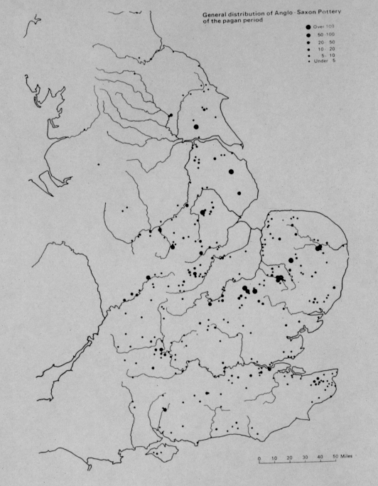
Figure 18 General Distribution of Anglo-Saxon Pottery of the Pagan Period from Myers, 1969.
From this it is clear that the Mercian kingdom of the seventh and eighth centuries is itself an amalgam, and that at the time of the Tribal Hidage, the areas of greatest Anglo-Saxon migration were still so locally disunited that the administrators regarded small tribal units as the best grouping for tax collection. With the possible exception of Original Mercia itself, the larger and more organized zones of the Tribal Hidage were Romano-British. As I have suggested in the discussion both of artifacts and place-names, above, this is a substantial response to the query: How much survives from Romano Britain? Clearly a great deal.
If we now turn to Original Mercia, some interesting conjectures arise. In the first place, how realistic is the common assumption that the marches of the name Mercia are the borders with the Welsh or the Northumbrians (cf Kirby and Hart)? Neither seems likely, in view of the geographical placing of Original Mercia in the central Trent and Teme-unless by "Welsh" one simply means "British" and Trent British at that. In detail there is a most perplexing division in artifacts distribution close to Burton-on-Trent. To the east of this area "Germanic" finds and cremation cemeteries are to be found. To the west is a rapid fall off in finds as far as Catholme and Wychnor cemetery, and beyond this nothing at all. What is perplexing about this north/south divide is that there is nothing geographically or geologically to explain it, since it runs across the flat Trent valley. It is interesting to note several "walh" and one "Bretton" place-names along this line.
The second area which requires some explanation is the left bank of the Trent below Nottingham. Indeed, as map 1 and map 2 in the Gazetteer shows, a large area which includes much of central and north Nottinghamshire is almost entirely free of Anglo-Saxon material of the migration period. This is not for lack of looking, and it is an area in which material of earlier (and later) periods has been found by fieldwork and excavation (info. from D. Garton, Trent and Peak Archaeological Trust). What we seem to be seeing is a "shadow" or "black hole" in the centre and at the northeast edge of Original Mercia. Considering the notorious invisibility of the British even when they are clearly present (eg. West Midlands, Elmet: Faull, 1981, 174), it is tempting to see the pattern of cremation cemeteries and "Germanic" artifacts here being brought up short against a body of British established in central Nottingham and in Staffordshire. So far the evidence concurs; to suggest that this border (in the heartland of what was regarded as Original Mercia) was what gave the kingdom its name must be much more tentative, but it fits well with the patterns shown by the maps.
CONCLUSION
The seventh century was, as we saw earlier in the written sources, the age of the accumulation of and struggle for political power. The written sources described it in terms of the rise of dynasties and the battle for territory and loot. The graves tell of its social ramifications, of the increasing wealth and power of small groups of successful nobles and princes, and of their control over the acquisition and distribution of scarce and valuable objects. The finds in these graves are prestige objects, which marked out their owner's life and were accumulated and redistributed in the halls of kings. The rare, sometimes imported goods and weapons which the nobility sought and kings gave away, were the objects of war and looting. In the cemetery evidence, the social changes which accompanied the kingdom-building and the rise of dynasties can be glimpsed.
To Go Back to Chapter 6 press 
To Continue to Conclusion press 
Copyright 2005 tst4eco.geo@yahoo.com